
Hampden County is a non-governmental county located in the Pioneer Valley of the U.S. state of Massachusetts, in the United States. As of the 2020 census, Hampden County's population was 465,825. Its traditional county seat is Springfield, the Connecticut River Valley's largest city, and economic and cultural capital; with an estimated population of 154,758, approximately one-third of Hampden County residents live in Springfield.

Forest Park in Springfield, Massachusetts, is one of the largest urban, municipal parks in the United States, covering 735 acres (297 ha) of land overlooking the Connecticut River. Forest Park features a zoo, aquatic gardens, and outdoor amphitheater, in addition to design elements like winding wooded trails, and surprising, expansive views. The site of America's first public, municipal swimming pool, currently, during the holiday months Forest Park hosts a popular high-tech lighting display, known as Bright Nights. Contrary to popular belief, the park was not designed by Frederick Law Olmsted, although it was designed by his firm.

The Broad Brook Canal is a water-supply canal feeding the Springfield Reservoir in Ludlow, Massachusetts, a public water supply for the city of Springfield, Massachusetts. Its northern segment is also known as the Jabish Canal.
Little Italy, Connellsville is an area on the west side of Connellsville, in Fayette County, Pennsylvania.
Mulberry Street is a historic street and tourist destination in Springfield, Massachusetts. Made famous by Dr. Seuss' first children's book And to Think That I Saw It on Mulberry Street, the street is less than one mile from Springfield's Metro Center neighborhood, the Springfield Armory, and the Quadrangle. It is also less than one mile southwest of Dr. Seuss' boyhood home on Fairfield Street.

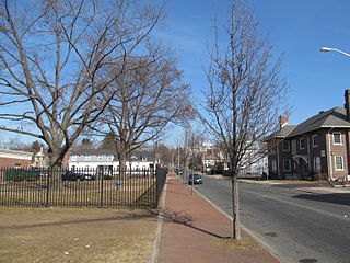
East Forest Park is a neighborhood in the south-central part of Springfield, Massachusetts. The neighborhood borders East Longmeadow, Forest Park, and the Sixteen Acres neighborhood. It is a primarily residential middle-class neighborhood.

Indian Orchard is a village in Springfield, Massachusetts. Located in the northeast corner of Springfield, next to the Chicopee River, Indian Orchard is the city's fifth largest neighborhood.
East Springfield is a neighborhood located in Springfield, Massachusetts.

Liberty Heights is a neighborhood in Springfield, Massachusetts, named for its main thoroughfare of Liberty Street.
The Six Corners and Maple Heights neighborhoods are located in Springfield, Massachusetts. They are often combined for political purposes, although they feature dramatically different political and socioeconomic characteristics.
Boston Road is Springfield, Massachusetts's principal commercial and retail corridor, located on the eastern edge of the city. The Boston Road neighborhood, historically known as Springfield Plain, is named for being a major waypoint on the Boston Post Road system.
The McKnight National Register Historic District is a neighborhood of Springfield, Massachusetts, and was one of the first planned residential neighborhoods in the United States. It is one of the city's smallest neighborhoods, at 306.5 acres.
The North End of Springfield, Massachusetts, is a name that describes three distinct Springfield neighborhoods: Brightwood, Memorial Square, and Liberty Heights. For more than a century, Springfield's North End neighborhood has served as a first home for some of the city's various immigrant communities, from Greeks in Memorial Square to Russians in Liberty Heights. As of 2011, the contemporary Puerto Rican flavor of the North End is evident in numerous banners depicting traditional Carnival masks and the coquí, Puerto Rico's unofficial mascot.

The Brightwood neighborhood of Springfield, Massachusetts, is located in the northwest corner of the city, along the Connecticut River; however, it is separated from the rest of Springfield by the Interstate 91 elevated highway. Many recent academic papers at the University of Massachusetts Amherst' School of Urban Design have focused on the detrimental physical and sociological effects that Interstate 91 has had on the Brightwood neighborhood and on Springfield in general.
Old Hill is one of the seventeen neighborhoods of Springfield, Massachusetts. It is composed, almost entirely, of Victorian buildings overlooking Springfield's Metro Center.
The Entertainment District is located in Springfield, Massachusetts, in the Metro Center district surrounding historic Stearns Square. Stearns Square is bordered by Worthington Street to the north and Bridge Street to the south; however, the Entertainment District extends for several city blocks north, south, east and west of Stearns Square. For over 100 years, this area of Springfield, surrounding Stearns Square and Springfield Union Station have been home to the city's most prominent clubs, restaurants, bars, music venues, movies houses, and coffee houses. Currently, there are over 75 restaurants, nightclubs, and bars in Springfield's Entertainment District, making it the largest entertainment district between New York City and Montreal, Canada. The Entertainment District is a primary reason why Springfield was recently ranked among America's Top Ten Best Cities for Singles by Yahoo and Sperling's Best Places.
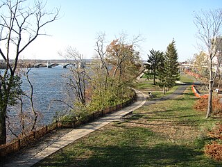
The Connecticut River Walk is partially constructed park and bikeway in Springfield, Massachusetts, United States, along the banks of New England's largest river, the Connecticut River. Currently, Springfield's section of this park is 3.7 miles (6 km) long, running from Chicopee, Massachusetts to the South End Bridge in Springfield, Massachusetts. Unusual features of the trail include its path alongside an active train line, making it a "rail-with-trail," and its passing in very close proximity to the Naismith Memorial Basketball Hall of Fame. The longest river in New England, the Connecticut River is the Knowledge Corridor's most prominent natural asset. For centuries it has been a source of regional identity and pride; however, currently most residents are cut off from it by Interstate 91 - a 1960s-era elevated highway, which has become a major inhibitor to Springfield's economic and recreational riverfront growth, especially in recent years.
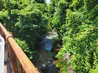
The Mill River is a 1.25-mile-long (2.01 km) tributary of the Connecticut River in Springfield, Massachusetts. It flows from Watershops Pond to its confluence with the Connecticut River. It is referred to as "The Miracle Mile" in a 2009 master's thesis that outlines possibilities for reclaiming the river's mouth as a recreational area. As of 2011, the final 350 feet (110 m) of the river, including its mouth, is confined in a pipe underneath Interstate 91, railroad tracks and a car dealership. Many Springfield residents have bemoaned the loss of the Mill River as a recreational area, and hope to gain greater access to both it and the Connecticut River in upcoming years. As it has for over a century, today the Mill River serves as a barrier between Springfield neighborhoods. Surrounding it are some of the most densely urbanized locations in Springfield.

Stone Dog II is a granite statue of a golden retriever posed standing guard in front of the Zoo at Forest Park in Springfield, Massachusetts. This 2013 statue, crafted by Getty Granite in Connecticut, replaced the original Stone Dog which went missing from the park in 1987, and continues a tradition with roots in the late 19th century. The present statue is almost identical to the original, measuring about 2.5 feet tall, 4 feet long, and 2 feet wide, and weighing approximately 1,000 pounds.

