
OC Transpo, officially the Ottawa-Carleton Regional Transit Commission, is the public transit agency for the city of Ottawa, Ontario, Canada. It operates an integrated hub-and-spoke system including light metro, bus rapid transit, conventional bus routes, and Para Transpo door-to-door accessible bus service. In 2021, the system had a ridership of 44,668,900.
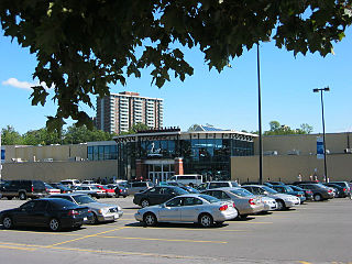
Billings Bridge Shopping Centre is a shopping mall located in the Billings Bridge neighbourhood of Ottawa, Ontario, Canada. It is a medium-sized community mall with 83 stores and services. Roughly 7.5 million people visit the mall every year and sales are about $527/sq foot. When built, it was the first strip mall in Ottawa, although it has since become an enclosed mall. It is located immediately south of the Rideau River on the corner of Bank Street and Riverside Drive. The mall's anchor stores are Walmart and Your Independent Grocer.

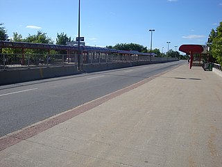
The Transitway is a bus rapid transit (BRT) network operated by OC Transpo in Ottawa, Ontario, Canada. It comprises a series of bus-only roadways and reserved lanes on city streets and highways. The dedicated busways ensure that buses and emergency vehicles on the Transitway rarely intersect directly with the regular traffic, and make it possible for them to continue at full speed even during rush hour. OC Transpo operates a network of rapid routes which use the Transitway to connect communities with the O-Train light rail system. Additional bus routes also use segments of the Transitway.

Barrhaven is a suburb of Ottawa, Ontario, Canada. It is located about 17 km (11 mi) southwest of the city's downtown core. Prior to amalgamation with Ottawa in 2001, Barrhaven was part of the City of Nepean. Its population as of the Canada 2021 Census was 103,234.

Downtown Ottawa is the central area of Ottawa, Ontario, Canada. It is sometimes referred to as the Central Business District and contains Ottawa's financial district. It is bordered by the Ottawa River to the north, the Rideau Canal to the east, Gloucester Street to the south and Bronson Avenue to the west. This area and the residential neighbourhood to the south are also known locally as 'Centretown'. The total population of the area is 4,876.

Billings Bridge is a station on the OC Transpo Transitway, adjacent to the Billings Bridge Plaza, Ottawa, Ontario, Canada. It is named for, not only the plaza, but after Billings Bridge itself which is both a nearby bridge and neighbourhood. The transitway station itself is a major stop on the southern transitway-line due to its location near Bank Street, Ottawa's major north–south road and the mall itself. The station is located just south of the Plaza near the intersection between Bank Street and Riverside Drive.

Greenboro is a transitway stop and future O-Train Trillium Line station in Ottawa, Ontario, Canada. It is located at Bank Street and Johnston Road at the north end of the South Keys shopping complex. The station has a 678-space paid park and ride lot reserved to monthly pass holders. The bus terminus was opened with the southern transitway on September 2, 1995.

The Trillium Line, also called O-Train Line 2, is a diesel light rail transit (DLRT) service in Ottawa, Ontario, Canada, operated by OC Transpo. The line has been closed since May 2020 for service expansion.

The Sir John A. Macdonald Parkway, formerly the Ottawa River Parkway, is a four-lane scenic parkway along the Ottawa River in Ottawa, Ontario, Canada. It runs from Carling Avenue near Connaught Avenue, to Booth Street at the Canadian War Museum and National Holocaust Monument. It is maintained by the National Capital Commission. The speed limit is 60 km/h (37 mph). Bicycles are allowed on the road and on a parallel recreational path along the parkway.
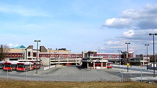
South Keys station is a stop on Ottawa's transitway system. Operated by OC Transpo, it is last station at the southern end of the Transitway, just north of Hunt Club Road. The station is located in the South Keys neighbourhood of Ottawa at the south end of the South Keys Shopping Centre beside the Cineplex Odeon South Keys Cinemas, between Bank Street and the Airport Parkway. The station was opened to traffic with the southern transitway on September 2, 1995.
Bayshore is a station on the transitway in Ottawa, Ontario, served by OC Transpo buses. It is located in the western transitway section at the Bayshore Shopping Centre in the neighbourhood of Bayshore.

Bayshore Shopping Centre is a major shopping mall located in the Nepean district of Ottawa, Ontario, Canada. The mall is one of the busiest in the National Capital Region as it attracts almost 8 million visitors per year from across the city and the surrounding region. It is the second largest shopping mall in the National Capital Region. It is anchored by Hudson's Bay, a combined Winners/HomeSense store and Walmart Supercentre.

Place d'Orléans is a transitway station in the suburb of Orléans in the former city of Gloucester in Ottawa, Ontario, Canada. The station opened in 1994, just off Regional Road 174 and Champlain Street right next to Place d'Orléans Shopping Centre. It is the main transit hub between local routes in Orléans and route 39.

St. Laurent Centre is a shopping mall located in Ottawa, Ontario, Canada. It is owned and operated by Morguard REIT. The shopping mall is located just north of Highway 417 at the corner of St. Laurent Boulevard and Coventry Road.

Marketplace is a Southwest Transitway station in the Barrhaven neighbourhood of Ottawa, Ontario, Canada. The station is located at the Chapman Mills Marketplace shopping centre, an extensive commercial zone which contains big-box stores and department stores.

Fallowfield station or Fallowfield Train Station is an inter-city passenger railway station and bus rapid transit station located at 3347 Fallowfield Road in the suburban neighbourhood of Barrhaven in Ottawa, Ontario, Canada.

South Keys is a neighbourhood in Gloucester-Southgate Ward in the south end of Ottawa, Ontario, Canada. It is bounded by Johnston Road to the north, Albion Road to the east, the Airport Parkway to the west, and Hunt Club Road to the south. According to the Canada 2011 Census, the neighbourhood has a population of 2,849. The neighbourhood is part of the South Keys Greenboro Community Association.

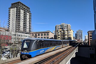
The O-Train is a light metro transit system in Ottawa, Ontario, Canada, operated by OC Transpo. The O-Train system has two lines, the electrically-operated Confederation Line and the diesel-operated Trillium Line. Since May 2020, Stage 2 construction has temporarily shut down Line 2, with replacement bus service being offered at all stations. When Line 2 reopens in mid-2023, it will extend southward to Limebank station and incorporate five newly constructed stations, as well as an additional line linking Line 2 to Ottawa International Airport which will replace the current bus service from route 97. By 2026, expansions along Line 1 and the construction of Line 3 stations in the west end are expected to be complete, bringing the system's length to 64.5 km (40.1 mi), four lines and 41 stations. The O-Train network is fully grade separated and does not have any level crossings with roads.
Urban rail transit in Canada encompasses a broad range of rail mass transit systems, including commuter rail, rapid transit, light rail, and streetcar systems.

