Sulawesi, also known as Celebes, is one of the four Greater Sunda Islands. It is governed by Indonesia. The world's eleventh-largest island, it is situated east of Borneo, west of the Maluku Islands, and south of Mindanao and the Sulu Archipelago. Within Indonesia, only Sumatra, Borneo and Papua are larger in territory, and only Java and Sumatra have larger populations.
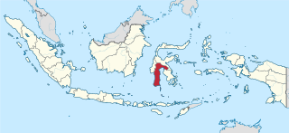
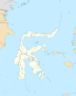
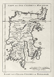
South Sulawesi is a province in the southern peninsula of Sulawesi. The Selayar Islands archipelago to the south of Sulawesi is also part of the province. The capital is Makassar. The province is bordered by Central Sulawesi and West Sulawesi to the north, the Gulf of Bone and Southeast Sulawesi to the east, Makassar Strait to the west, and Flores Sea to the south.

North Sulawesi is a province of Indonesia. It is located on the Minahasa Peninsula of Sulawesi, south of the Philippines and southeast of Sabah, Malaysia. It borders Davao and Soccsksargen regions of the Philippines to the north, the Maluku Sea to the east, Gorontalo and Celebes Sea to the west and the Gulf of Tomini to the southwest. With Miangas, it is the northernmost province of Indonesia. The province's area is 13,892.47 square kilometres (5,363.91 sq mi), and its population was 2,270,596 according to the 2010 census; this rose to 2,621,923 at the 2020 Census.

Southeast Sulawesi is a province on the island of Sulawesi, forming the southeastern peninsula of that island, together with a number of substantial offshore islands such as Buton, Muna, Kabaena and Wawonii, together with many smaller islands. The capital is the city of Kendari, on the east coast of the peninsula.

The Celebes Sea of the western Pacific Ocean is bordered on the north by the Sulu Archipelago and Sulu Sea and Mindanao Island of the Philippines, on the east by the Sangihe Islands chain, on the south by Sulawesi's Minahasa Peninsula, and on the west by northern Kalimantan in Indonesia. It extends 420 miles (675 km) north-south by 520 mi (840 km) east-west and has a total surface area of 110,000 square miles (280,000 km2), to a maximum depth of 20,300 feet (6,200 m). South of the Cape Mangkalihat, the sea opens southwest through the Makassar Strait into the Java Sea.
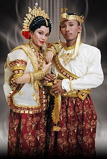
The Buginese or Bugis people are an ethnic group—the most numerous of the three major linguistic and ethnic groups of South Sulawesi, in the southwestern province of Sulawesi, third largest island of Indonesia. The Bugis in 1605 converted to Islam from Animism. The main religion embraced by the Bugis is Islam, with a minority adhering to Christianity or a pre-Islamic indigenous belief called Tolotang.

Buton, is an island in Indonesia located off the southeast peninsula of Sulawesi. It covers roughly 4,408 square kilometers in area, or about the size of Madura; it is the 129th largest island in the world and Indonesia's 19th largest in area.

Geologically, the Sunda Shelf is a southeast extension of the continental shelf of Southeast Asia. Major landmasses on the shelf include the Malay Peninsula, Sumatra, Borneo, Java, Madura, Bali and their surrounding smaller islands. It covers an area of approximately 1.85 million km2. Sea depths over the shelf rarely exceed 50 metres and extensive areas are less than 20 metres resulting in strong bottom friction and strong tidal friction. Steep undersea gradients separate the Sunda Shelf from the Philippines, Sulawesi, and the Lesser Sunda Islands.
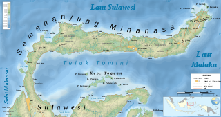
The Minahasa Peninsula, also spelled Minahassa, is one of the four principal peninsulas on the Indonesian island of Sulawesi. It stretches north from the central part of the island, before turning to the east and forming the northern boundary of the Gulf of Tomini and the southern boundary of the Celebes Sea.
The Kingdom of Luwu is generally thought to be the oldest kingdom in South Sulawesi. In 1889, the Dutch Governor of Makassar placed Luwu's heyday between the 10th and 14th centuries, but offered no evidence. The La Galigo, an epic poem composed in a literary form of the Bugis language, is the likely inspiration of Braam Morris’ dating. The La Galigo depicts a vaguely defined world of coastal and riverine kingdoms whose economies are based on trade. Two early centres of this world are Luwu and the kingdom of Cina in what is now Wajo. The incompatibility of the La Galigo's trade-based political economy with the agricultural economies of other South Sulawesi kingdoms has led scholars to posit an intervening period of chaos to separate the two societies chronologically.
The Wotu–Wolio languages are a group of closely related languages spoken in Sulawesi that belong to the Celebic subgroup of the Austronesian family.

The Gulf of Boni, also known as the Gulf of Bone, Bay of Boni, and Bone Bay, is the gulf which divides the South and Southeast Peninsulas of the island of Sulawesi (Celebes) in Indonesia. It opens on the south into the Banda Sea.

Sinjai Regency is a regency of South Sulawesi Province of Indonesia. The regency is separated from the Bone Regency to its north by the River Tangka. The regency covers an area of 819.96 km2 and had a population of 228,936 at the 2010 Census and 259,478 at the 2020 Census. It includes the Nine Islands in the Gulf of Bone off the east coast of the southern peninsula of Sulawesi, a group which forms a district within the regency. The regency's principal town lies at Sinjai, a port situated on the east coast of that peninsula.
Bajaw is the language of the Bajaw, widely known as the 'sea gypsies' of Maritime Southeast Asia. Differences exist between the language's varieties in western Sabah, Mapun in southern Philippines, eastern Sabah, and across Sulawesi to Maluku. However, it is not clear how many languag
The Gulf of Tolo, also known as the Bay of Tolo, is the body of water lying between the eastern and south-eastern peninsulas of the island of Sulawesi (Celebes) in Indonesia.

Gorontalo is a province of Indonesia on the island of Sulawesi. Located on the Minahasa Peninsula, Gorontalo was formerly part of the province of North Sulawesi until its inauguration as a separate province on 5 December 2000. In Indonesian history, the only Indonesian President from the Gorontaloan people is the third President of the Republic of Indonesia, Prof. DR. Ing. Bacharuddin Jusuf Habibie. His father, Alwi Abdul Jalil Habibie, comes from the "Habibie" clan.
The Northern South Sulawesi languages are a subgroup of the South Sulawesi languages in the Austronesian language family. They are spoken in an area that stretches from the western peninsula of Sulawesi to the Gulf of Bone. Its most prominent members are Mandar and Toraja.

The Sulawesi lowland rain forests is a tropical moist forest ecoregion in Indonesia. The ecoregion includes the lowlands of Sulawesi and neighboring islands.