Assab or Aseb is a port city in the Southern Red Sea Region of Eritrea. It is situated on the west coast of the Red Sea. Languages spoken in Assab are predominately Afar, Tigrinya, and Arabic.

The Buri Peninsula extends from central Eritrea north into the Red Sea.

Elabered Subregion is a subregion in the northwestern Anseba region of Eritrea. Its capital lies at Elabered.
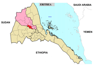
Hagaz Subregion is a subregion in the northwestern Anseba region of Eritrea. Its capital lies at Hagaz (Hagat).

Halhal Subregion is a subregion in the northwestern Anseba region of Eritrea. Situated 12 km north of Keren (Cheren), its capital lies at Halhal.

Keren Subregion is a subregion in the northwestern Anseba region of Eritrea. Its capital lies at Keren (Cheren).

Kerkebet Subregion is a subregion in the northwestern Anseba region of Eritrea. Its capital lies at Kerkebet (Carcabat).
Haykota Subregion is a subregion in the western Gash-Barka region of Eritrea. Its capital lies at Haykota.
Logo Anseba Subregion is a subregion in the western Gash-Barka Region of Eritrea. Its capital lies at Logo Anseba.
Ghela'elo Subregion is a subregion in the Northern Red Sea region of Eritrea. Its capital lies at Ghela'elo (Ghelalo).
Adi Keyh Subregion is a subregion in the Debub (Southern) region of Eritrea. Its capital lies at Adi Keyh.
Adi Quala Subregion is a subregion in the southern Debub region of Eritrea. Its capital lies at Adi Quala.
Areza Subregion is a subregion in the Debub (Southern) region of Eritrea. Its capital lies at Areza.
Debarwa Subregion is a subregion in the southern Debub region of Eritrea. Its capital lies at Debarwa.
Dekemhare Subregion is a subregion in the southern Debub region of Eritrea. Its capital lies at Dekemhare.
Kudo Be'ur Subregion is a subregion in the Debub (Southern) region of Eritrea. Its capital lies at Kudo Be'ur.
Mendefera Subregion is a subregion in the Debub (Southern) region of Eritrea. Its capital lies at Mendefera.
Senafe Subregion is a subregion in the Debub (Southern) region of Eritrea. Its capital is Senafe, and high points include Emba Soira.
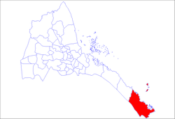
Central Denkalya Subregion is a subregion in the Southern Red Sea region of Eritrea. It is bordered to the northwest by the Are'eta Subregion, to the southeast by the Southern Denkalya Subregion, to the north by the Red Sea, and to the south by Ethiopia.
Assab Subregion is a district in the Southern Red Sea region of Eritrea.