Soviet infrastructure in Central Asia

Last updated

Much of the influence of the Soviet Union can be seen in the infrastructure of Central Asia. Central Asia is a nexus of said infrastructure for transportation, goods delivery and energy distribution. Much of the industrial infrastructure had greatly declined in the 1990s, after the fall of the Soviet Union, especially in Kyrgyzstan and Tajikistan. The roads, railroads and energy lines are thus oriented towards the Russian Federation and away from other regional neighbors, such as China, Afghanistan or Iran.

Contents

Soviet steam locomotive Tashkent Soviet-steam-locomotive-te-5200-ex-german-52-tashkent.jpg
Soviet steam locomotive Tashkent

Railroad Transportation

The Central Asian railroad network was designed primarily with the needs of former Soviet Union planners in mind. The entire Soviet railways system was built with Moscow at its core. Consequently, Central Asian railroads are mainly oriented north-south and (now-existing) borders were disregarded in planning. As a result, virtually all freight cargo from Central Asia to Russia crosses Kazakhstan, including trade with Europe. Uzbekistan also has significant transit traffic. [1]

Major Soviet Railroads, 1986 Major Soviet Railroads, 1986.png
Major Soviet Railroads, 1986

The total length of the rail network in the four CARs is about 19,600 kilometers (km) but size varies by country.

Soviet Rail Management

During the Soviet era, railways of the Central Asian countries were under the auspices of the Ministry of Railways, separated regionally into:

Diesel-locomotive shunter TEM-7 1982. TEM 7.jpg
Diesel-locomotive shunter TEM-7
  1. Alma-Ata Railway Bureau (southern Kazakhstan and northern Kyrgyzstan)
  2. Tselinnaya Railway Bureau (northern Kazakhstan)
  3. West-Kazakhstan Railway Bureau
  4. Central Asian Railway Bureau (entire Central Asian region excluding Kazakhstan and northern Kyrgyzstan)

The Kazakh Railroad is one of the 7 divisions of the Southern Urals Railroad. It was formed in 1958 out of the Turkestan-Siberian and Karaganda railroads and sections of the former Tashkent, Orenburg, and Southern Urals railroads. [2] The principal trunk line connected Kazakhstan to the Urals and the Volga region. The Kinel'-Orenburg-Iletsk trunk line connected the European regions of the USSR with Kazakhstan and the rest of Central Asia. The principal commodities transported were coal (22%), ferrous metals (12%), oil (10%), and building materials (9%). The Southern Urals Railroad was awarded the Order of the October Revolution in 1971. [3] In 1971, this railroad had 13,250 km of track, representing 9% of the total rail network of the USSR. [2] While some of the lines were built in 1915-17, 80% of the lines were built in the Soviet period. In 1971, the Kazakh Railroad was awarded the Order of Lenin.

After independence, each country nationalized and progressively took control of their own railways. Kazakhstan's three companies were merged into a single one in 1997. [4]

Due to the specialization in the railway manufacturing sector under the COMECON regime (Council for Mutual Economic Assistance – the Soviet international assistance framework), most passenger cars were made in East Germany, locomotives were made in Russia and Czechoslovakia. As there are no railroad locomotive or car manufacturers in Central Asia, there is a constant shortage of spare parts and an inability to properly maintain railroad vehicles. [5]

In the USSR, the power supply system of an electric railroad is closely tied to the overall power system. Electricity arrives from substations in high-voltage power transmission lines, is converted, and then transmitted over feed and negative booster lines to the contact system and then to the rolling stock. Depending on the equipment in the rolling stock, the power may be supplied over DC systems using single-phase systems at the commercial frequency (50 hertz) or lower (16 2/3 or 25 Hz). The DC systems in the USSR had a nominal voltage of 3 kilovolts. [6] In 1956, the Central Committee of the Soviet Union adopted the General Plan for the Electrification of Railroads - after which major rail routes were upgraded.

Rail gauge

Bishkek rail overpass E7939-Bishkek-rail-overpass.jpg
Bishkek rail overpass

Rail gauge in former Soviet territory differs from the gauge in the rest of the world. Rail tracks in the former Soviet territories are on a broad-gauge track of 1,524 millimeters (60 inches) versus the global standard gauge of 1,435 millimeters used in China, most of Europe, North America, most of Australia, Iran and Turkey. The Russian Empire and the Soviet Union intentionally used a different gauge (ostensibly to block invaders from entering Russia by rail)[ citation needed ]. Consequently, trains on the current rail line from China to Kazakhstan must stop at the border, where cargo is unloaded and then reloaded onto trains on the broad-gauge rail line in Kazakhstan for transit through Central Asia. [7]

During Soviet times, locomotives and wagons were regularly supplied on the basis of estimated needs. When the Soviet Union broke up, shares of the Soviet wagon fleet were allocated to the various republics; the smaller ones did not get the better deals. As a feature of the Soviet system, state-owned rail companies provide provided social welfare services such as free education and housing to their workers. After independence, each country had to figure out how to address these obligations (without Soviet funding). In Soviet times, marketing was not a concern for railways since their clients were for the most part assigned to them by a central planning agency. To increase revenues after the dissolution of the Union, railways had either to find more clients or to increase tariffs.

Rail prominence and decline

The new railways faced difficulties adopting monolithic organizations with large social welfare burdens and aging equipment.

  1. The Kyrgyz Republic and Tajikistan started national railways from scratch as they were left with only branches of Soviet companies.
  2. The railways changed from a command economy in which the only client was the state to a market economy with many clients, each with its own requirements and free to choose another, more suitable transport mode.
  3. Networks were not designed with a national economy in mind and were poorly connected often necessitating crossing borders to travel between regions of a country.
  4. There was a sharp fall in traffic volume, which has started picking up since 1999.

In the CIS, an inter-governmental agreement was signed as early as 14 February 1992. This organization coordinates the operations and development of the railways and has facilitated several important agreements on tariffs. [8]

Regional traffic in Central Asia is overwhelmingly carried by rail, estimated at 90%. [9] For trade within Central Asia, roadways carry only 22% of all goods. [10] The Kazak railway, via Kzyl-Orda and Aralsk, has traditionally provided the main connection between Uzbekistan and the Kyrgyz Republic and between European Russia and Northern Europe and now provides a route to the Caspian Sea port of Aktau. The railway in Uzbekistan via Navoi and Nukus and then through Makat in Kazakhstan provides a link between southern Uzbekistan, Turkmenistan, and Tajikistan to western Siberia. It also provides an alternative east-west link to the Kzyl-Orda-Aralsk route via Aktau. [11]

In the 1990s a sharp decrease in traffic led to a period of large surpluses when only the best wagons were used. Many of the worst were either scrapped or cannibalized to maintain the others. At the time of independence, the number of freight wagons in Kazakhstan was estimated to be 128,000. In 2001, the number was down to 78,000. Of those, at least 30% and probably more were out of service. About 43% of the remaining wagons were over 20 years old. [12]

Rail Border Concerns

The Soviet Union built rail lines that stop at the former Soviet boundary. Thus, out of five Central Asian countries, only Kazakhstan (with China at Dostyk/Druzhba-Alashankou) and Turkmenistan (with Iran at Serakhs) have rail connections beyond the CIS. The railways connect northern Kazakhstan with Russia along the northern Trans-Asian Railway (TAR). Initially planned in 1954, construction began in the 1950s but was not completed until 1990. Freight trains began running in July 1991, followed by passenger trains linking Almaty and Ürümqi (in Xinjiang) in June 1992. [13]

The Serakhs station that links the Russian gauge Turkmen network to the standard gauge Iranian network opened in 1996 for transit - to Iran and Turkey. [14] This line connects to the Iranian railway system but it does not carry freight to the Persian Gulf, thus preventing a direct link between Central Asia and seafaring routes. [15]

Thus, numerous underlying cross-border problems are at the root of the difficulties of regional rail transport. A lack of track-sharing agreements means that a single operator moving goods through two or more countries is not feasible. This causes time-consuming and costly border operations - trains have to change locomotives and crews at each border crossing. There is no system of sealing wagons (like under the TIR Convention) to avoid the need for customs inspections at borders or within transit countries. [16]

There is also a lack of regional uniform customs and other border controls that comply with international best practices, which makes documentation delays much more likely. Cargo documentation is often complicated with separate weigh bills for each country traversed; any documentation problem can result in the wagon being detained for several days. [16]

"The aging of the locomotive fleet does not imply a shortage in the short-term; the problem is rather obsolescence." [12]

Road Transportation

Taldyk pass (3600 m) Taldyk pass (3600 m).jpg
Taldyk pass (3600 m)

The relatively small populations, large land areas (particularly in Kazakhstan, Turkmenistan and Uzbekistan) and difficult mountainous terrain (especially in the Kyrgyz Republic and Tajikistan) increase infrastructure costs and pose challenges to maintenance of road infrastructure in Central Asia. The total road length under central government management (roads considered national highway) in Central Asia is 59,430 km, almost all of which is paved. [17] There are significant seasonal variations in road use due to the transportation of fresh agricultural products. Almost all food products are carried by road transport from south to north, particularly during the warmer months.

Soviet Road Building

see also Transport in the Soviet Union

In the USSR, five technical categories of highways existed, depending on the relation of the highway to the country's total transportation system and on the estimated traffic. The higher the estimated traffic, the higher the category of road (150 km/h for Category 1 down to 60 km/h for Category 5). [18]

The Soviet highways were differentiated into:

In Central Asia, the major highways which were built include:

On this highway, the largest highway tunnel in the USSR was built at an altitude of 3,200 meters stretching 2.5 km long.

Soviet road publications

Automotive Roads (Avtomobil'nye Dorogi) was a monthly industrial and technical magazine published by the Ministry of Transport Construction. It was published in Moscow beginning in 1954, dealing with questions of planning, building, repairing and maintaining highways. [21]

Automotive Transport (Avotmobil'nyi Transport) was a monthly manufacturing and technical publication published by the Ministry of Motor Vehicle Transportation and Highways and the Central Committee of the Trade Union of Employees of Motor Vehicle Transportation and Highways. Published in Moscow starting in 1923, it highlighted problems in organization shipments and vehicular transportation, design and repair of vehicles, training of employees and traffic safety, along with transportation abroad. [21]

Modern Road Infrastructure

In particular, Kyrgyzstan and Tajikistan are landlocked and heavily dependent on roads for trade and commerce. Their mountainous terrain makes transportation challenging and expensive."When it comes to the main road corridors, both governments plan to continue relying on big international and bilateral partners for aid in transportation construction. In Kyrgyzstan international organisations have invested over $400 million to rehabilitate 1,600km of roads between 1995 and 2008. China's Export Import Bank is the largest investor in the transportation infrastructure of Tajikistan…" [22] In Tajikistan, Japan's development agency is building a road south from the capital. [23] Typically, these investments are scattershot and targeted towards road infrastructure that can potentially carry international cargo. Following the Soviet legacy, they are also typically oriented along the north-south axis. The north-south road through eastern Kazakhstan (via Almaty and Aktogay) provides an important link between the Kyrgyz Republic (and Uzbekistan to a lesser extent) and eastern Siberia. The north-south road through Kyrgyz Republic and Tajikistan, links Kazakhstan and Xinjiang to Afghanistan and ports in Iran and Pakistan.

Pamir highway near Karakul Pamir highway near karakul.JPG
Pamir highway near Karakul

In Turkmenistan, which does not receive as much foreign aid but has substantial natural gas reserves, the Soviet system of management has largely remained in place. Five separate ministries are in charge of specific segments of the transportation sector. The government has not developed any master plan on road improvements, so upgrades do not take into account traffic volume, future building or maintenance costs. [24]

Poor road conditions are caused by overloading vehicles and a lack of preventive maintenance, due to funding constraints. [25] Much maintenance and repair is dependent on bilateral aid or is done piecemeal.

International Road Linkages

All Central Asian Republics are members of the International Road Union, which assists with implementation of international road transport agreements. In general, China does not participate in these broad multilateral agreements; however, it has made smaller-scale agreements. Most notable among those are the Transit Transport Agreement (PRC, Kazakhstan, Kyrgyz Republic, and Pakistan on March 9, 1995) and the Agreement on International Road Transport (PRC, Kyrgyz Republic, and Uzbekistan on 19 February 1998). [8]

Energy Infrastructure

Kurpsai Hydroelectric Station, Kyrgyzstan Kurpsai Hydroelectric Station.jpg
Kurpsai Hydroelectric Station, Kyrgyzstan

In the Soviet era, the United Energy System of Central Asia (UESCA) provided for the exchange of water and energy between the five Central Asian states. When the Soviet Union collapsed, these countries quickly discovered that their new, disconnected grids had significant gaps. [26] Under the arrangement prevalent during the Soviet Union, Kyrgyzstan and Tajikistan would supply water for irrigation purposes to Uzbekistan, Kazakhstan and Turkmenistan in summer. In winter Turkmenistan, Kazakhstan and Uzbekistan would supply gas to Tajikistan and Kyrgyzstan to cover their heating needs. UESCA began falling apart in 2003 when Turkmenistan declared its exit from the system. With the disintegration of Soviet-era sharing agreements, Tajikistan and Kyrgyzstan are facing drastic shortages in power supply. The winter shortage in Tajikistan is 500 MW. [27]

Hydroelectric Power

Until the 1950s, the USSR focused its hydroelectric construction in the European part of the Union, which was responsible for 65% of the hydroelectrical output of the USSR. [28] In subsequent decades, significant construction was taken up in the Volga, Far East and Central Asian rivers.

The Toktogul Hydroelectric Power Plant is located on the Naryn River in Osh oblast. The plant began operating in 1975 with 1,200 Megawatts capacity. It has a dam that is 215 meters high. The dam forms the Toktogul Reservoir which began filling in 1974. The reservoir covers 284 square km. The reservoir regulates the flow of the Naryn River, allowing for the irrigation of 0.5 million hectares of land. [29]

Construction of the Nurek Hydroelectric Power Plant began on the Vahsh River near Nurek, Tadzhik SSR in 1961. The dam is 300m high, with a volume of 56 million cubic meters. Electric power from the dam supplied the unified power grid of Central Asia through transmission lines operating at 500 and 220 kilovolts. The planned capacity was 2,700 Megawatts. The reservoir formed by the dam began filling in 1972, with an area of 98 square kilometers. It provided seasonal regulation of water flow and made possible the irrigation of 1 million hectares of land in the Karshi and Kzyl-Kum steppes and the Dangara Plateau. [30]

The Bukhtarma Hydroelectric Power Plant is located on the Irtysh River in Kazakhstan. It had an established capacity of 675 megawatts, with construction beginning in 1953, operating at full capacity in 1966. The dam height is 80 meters, forming the Bukhtarma Reservoir and providing electricity to east Kazakhstan. The reservoir began filling in 1960 with an area of 5,500 square km. It allows for irrigation of hundreds of thousands of acres of floodplains in several oblasts. [31]

The USSR built some of the highest dams in the world, with Nurek as the highest. Hydroelectric projects were also carried out in highly seismic regions (of which the Toktogul dam is a "9-point region"). [32]

Modern Strains on Soviet Energy Infrastructure

Uzbekistan and Turkmenistan have been living off the energy generating capacity built in the 1960s and 1970s, but this infrastructure is reaching its limits. [33] Although there is no shortage of power in Kyrgyzstan yet, demand is growing. The government allowed two thermal plants in Osh and Bishkek to deteriorate to the extent that now produces power shortages in winter. [34]

In Tajikistan the energy sector is used to support two key export industries – cotton and aluminium production. The ministry of water and irrigation is one of the largest debtors to Barki Tajik, the national electricity company. The Tajik Aluminium Company consumes between 40 and 50 per cent of all electricity and pays the lowest tariff in the country. The government argues that both sectors are crucial sources of revenue. After gaining independence in 1991 Kazakhstan moved to address strategic vulnerabilities of the energy system. At the time the northern part of the country was linked with the Russian grid, while southern regions draw their supply from the unified regional system. By building two north-south transmission lines (one in 1997 and the other in 2009) the country connected its southern territories to major sources of energy in the north and decreased dependence on its neighbours. [35]

In the Kyrgyz Republic, the gate price of heating oil is $50 per ton at the refinery in the south of the country. Bringing it to the north by rail, however, may cost as much as $27–30 because it must pass through Uzbekistan, Tajikistan, and Kazakhstan. That means oil will sell for about $90 in the north. For coal, the share of transport costs in the final price is even higher. [36]

Related Research Articles

<span class="mw-page-title-main">Transport in Kyrgyzstan</span> Overview of the transport in Kyrgyzstan

Transport in Kyrgyzstan is severely constrained by the country's alpine topography. Roads have to snake up steep valleys, cross passes of 3,000 m (9,843 ft) altitude and more, and are subject to frequent mud slides and snow avalanches. Winter travel is close to impossible in many of the more remote and high-altitude regions. Additional problems are because many roads and railway lines built during the Soviet period are today intersected by international boundaries, requiring time-consuming border formalities to cross where they are not completely closed. The horse is still a much used transport option, especially in rural and inaccessible areas, as it does not depend on imported fuel.

Transport in Turkmenistan includes roadways, railways, airways, seaways, and waterways, as well as oil-, gas-, and water pipelines. Road-, rail-, and waterway transport fall under the jurisdiction of the Ministry of Industry and Communications.

As of 2007, Uzbekistan's overland transportation infrastructure declined significantly in the post-Soviet era due to low investment and poor maintenance. Air transport was the only branch that received substantial government investment in the early 2000s, as airport modernization projects were undertaken. In the following years, improvements have been made to the surface transport network including the construction of the Tashkent–Samarkand high-speed rail line.

<span class="mw-page-title-main">Kyrgyzstan</span> Country in Central Asia

Kyrgyzstan, officially the Kyrgyz Republic, is a landlocked country in Central Asia, lying in the Tian Shan and Pamir mountain ranges. Bishkek is the capital and largest city of the country. Kyrgyzstan is bordered by Kazakhstan to the north, Uzbekistan to the west, Tajikistan to the south, and China to the east and southeast. Ethnic Kyrgyz make up the majority of the country's seven million people, followed by significant minorities of Uzbeks and Russians.

<span class="mw-page-title-main">Islamic Republic of Iran Railways</span> State-owned rail company

The Islamic Republic of Iran Railways is the national state-owned railway system of Iran. The Raja Passenger Train Company is an associate of the IR, and manages its passenger trains. The Railway Transportation Company is an associate of the IR, which manages its freight transport. The Ministry of Roads & Urban Development is the state agency that oversees the IRIR. Some 33 million tonnes of goods and 29 million passengers are transported annually by the rail transportation network, accounting for 9 percent and 11 percent of all transportation in Iran, respectively (2011).

<span class="mw-page-title-main">Soviet Central Asia</span> Section of Central Asia formerly controlled by the Soviet Union

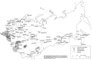
Soviet Central Asia was the part of Central Asia administered by the Soviet Union between 1918 and 1991, when the Central Asian republics declared independence. It is nearly synonymous with Russian Turkestan in the Russian Empire. Soviet Central Asia went through many territorial divisions before the current borders were created in the 1920s and 1930s.

Kazakhstan Temir Joly, also National Company Kazakhstan Temir Joly, is the national railway company of Kazakhstan.

<span class="mw-page-title-main">Rail transport in Afghanistan</span> Afghan railway system

Afghanistan has three railway lines in the north of the country. The first is between Mazar-i-Sharif and the border town of Hairatan in Balkh province, which then connects with Uzbek Railways of Uzbekistan. The second links Torghundi in Herat province with Turkmen Railways of Turkmenistan. The third is between Turkmenistan and Aqina in Faryab province of Afghanistan, which extends south to the city of Andkhoy. The country currently lacks a passenger rail service, but a new rail link from Herat to Khaf in Iran for both cargo and passengers was recently completed. Passenger service is also proposed in Hairatan – Mazar-i-Sharif section and Mazar-i-Sharif – Aqina section.

<span class="mw-page-title-main">SA3 coupler</span> Automatic coupler for railway use

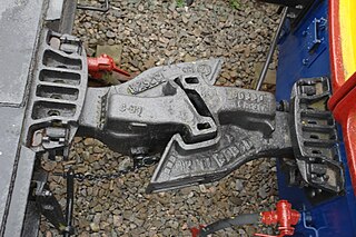
SA3 couplers or Willison coupler and Russian coupler are railway couplings used primarily in Russia and states influenced by the former Soviet Union, such as Finland, Poland, and Mongolia.

<span class="mw-page-title-main">Organization for Cooperation of Railways</span> Group of Members of the UIC

The Organization for Cooperation of Railways, was established as the equivalent of the International Union of Railways (UIC) to create and improve the coordination of international rail transport. Concerning especially the transports between Europe and Asia, it has helped develop cooperation between railway companies and with other international organisations. The members of this organisation created an international transport law.

<span class="mw-page-title-main">Kyrgyz Railways</span>

The Kyrgyz Railway (KTJ) is the national railway developer of Kyrgyzstan.

<span class="mw-page-title-main">Railways Agency of Turkmenistan</span> Turkmen government agency

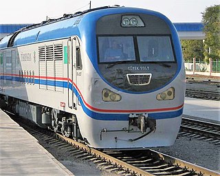
The Railways Agency of Turkmenistan (Turkmen: "Türkmendemirýollary" agentligi, previously the Ministry of Railways, is a government agency in Turkmenistan responsible for oversight of the state rail corporation "Demirýollary" AGPJ.

The history of the Jews in Central Asia dates back centuries, where Jews have lived in countries which include Kyrgyzstan, Kazakhstan, Tajikistan, Turkmenistan, and Uzbekistan.

<span class="mw-page-title-main">Kazakhstan–Turkmenistan border</span> International border

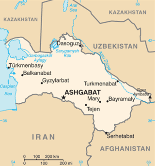
The Kazakhstan–Turkmenistan border is 413 kilometres (257 mi) in length and runs from the Caspian Sea to the tripoint with Uzbekistan. It is the shortest international boundary of both states.

<span class="mw-page-title-main">Turkmenistan–Uzbekistan border</span> International border

The Turkmenistan–Uzbekistan border is the border between the countries of the Republic of Turkmenistan and the Republic of Uzbekistan. At 1,793 km, it is Turkmenistan's longest border and Uzbekistan's second longest. The border runs from the tripoint with Kazakhstan to the tripoint with Afghanistan.

<span class="mw-page-title-main">Kazakhstan–Uzbekistan border</span> International border

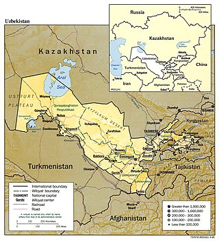
The Kazakhstan–Uzbekistan border is 2,330 km (1,450 mi) long and runs from the tripoint with Turkmenistan to the tripoint with Kyrgyzstan. It is Uzbekistan's longest external boundary. The Uzbek capital Tashkent is situated just 13 km (8.1 mi) from this border.

<span class="mw-page-title-main">Kazakhstan–Kyrgyzstan border</span> International border

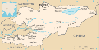
The Kazakhstan–Kyrgyzstan border is 1,212 kilometres (753 mi) and runs from the tripoint with Uzbekistan to the tripoint with China. Bishkek, the Kyrgyz capital, is situated just 16 km (10m) to the south of this boundary, and Almaty is situated just 29 kilometres (18 mi) to the north of it.

<span class="mw-page-title-main">Tajikistan–Uzbekistan border</span> International border

The Tajikistan–Uzbekistan border is an international border between Tajikistan and Uzbekistan. It is 1,312 kilometres (815 mi) in length and runs from the tripoint with Kyrgyzstan to the tripoint with Afghanistan.

<span class="mw-page-title-main">Kyrgyzstan–Uzbekistan border</span> International border

The Kyrgyzstan–Uzbekistan border is 1,314 kilometres (816 mi) in length and runs from the tripoint with Kazakhstan to the tripoint with Tajikistan. It is Kyrgyzstan's longest external boundary.

<span class="mw-page-title-main">Kyrgyzstan–Tajikistan border</span> International border

The border between Kyrgyzstan and Tajikistan is 984 kilometres (611 mi) long and runs from the tripoint with Uzbekistan to the tripoint with China.

References

  1. 1 2 Central Asia: Decay and Decline. p. 34
  2. 1 2 Prohorov (1976). 11: 501
  3. Prokhorov (1978). 30: 658
  4. Prakash. p. 21
  5. RIDA. p. 113
  6. Prohorov (1978). 30: 613
  7. "Wild Cats and Black Sheep".
  8. 1 2 Prakash. p. 18
  9. Otsuka. p. 48
  10. Prakash. p. 8
  11. Prakash. p. 10
  12. 1 2 Prakash. p. 24
  13. Otsuka. p. 43
  14. RIDA. p. 12
  15. Otsuka. p. 49
  16. 1 2 Prakash. p. 23
  17. Prakash. p. 12
  18. Prokhorov (1973). 1: 623
  19. Prokhorov (1973). 1: 625
  20. Prokhorov (1973). 1: 626
  21. 1 2 Prokhorov (1973). 1: 535
  22. Central Asia: Decay and Decline. p. 17
  23. "Japanese finance Tajik road construction" . Retrieved 1 May 2013.
  24. Central Asia: Decay and Decline. p. 27
  25. Prakash. p. 13
  26. Central Asia: Decay and Decline. p. 10
  27. "Proposed Grant Republic of Tajikistan: Regional Power Transmission Project" (PDF). Asian Development Bank. June 2010. Retrieved 1 May 2013.
  28. Prokhorov (1975). 6: 663
  29. Prokhorov (1977). 26: 204
  30. Prokhorov (1974). 18: 337
  31. Prokhorov (1970). 4: 167
  32. Prokhorov (1975). 6: 646
  33. RIDA. p. 25
  34. Central Asia: Decay and Decline. p. 12
  35. Central Asia: Decay and Decline. p. 33
  36. Prakash. p. 11

Sources

Central Asia: Decay and Decline. International Crisis Group (3 February 2011). Retrieved 17 April 2013.
Otsuka, Shigeru (2001). "Central Asian Railways and Europe-Asia Land Bridge". Japan Railway and Transport Review. Volume 28
Prakash, Manohan. "Connecting Central Asia A Road Map for Regional Cooperation". Asian Development Bank. Retrieved 17 April 2013.
Prokhorov, A.M. (ed.) (1970) Great Soviet Encyclopedia (English translation) (3rd ed.) New York: Macmillan Inc.
Prokhorov, A.M. (ed.) (1973) Great Soviet Encyclopedia (English translation) (3rd ed.) New York: Macmillan Inc.
Prokhorov, A.M. (ed.) (1974) Great Soviet Encyclopedia (English translation) (3rd ed.) New York: Macmillan Inc.
Prokhorov, A.M. (ed.) (1975) Great Soviet Encyclopedia (English translation) (3rd ed.) New York: Macmillan Inc.
Prokhorov, A.M. (ed.) (1976) Great Soviet Encyclopedia (English translation) (3rd ed.) New York: Macmillan Inc.
Prokhorov, A.M. (ed.) (1977) Great Soviet Encyclopedia (English translation) (3rd ed.) New York: Macmillan Inc.
Prokhorov, A.M. (ed.) (1978) Great Soviet Encyclopedia (English translation) (3rd ed.) New York: Macmillan Inc.
RIDA (Research Institute Of Development Assistance) (1998): Regional cooperation in Central Asia : focusing on infrastructure development. OECF