
Naples Airport, formerly known as Naples Municipal Airport, is a public use airport located two nautical miles (4 km) northeast of the central business district of Naples, the most populous city and county seat of Collier County, Florida. It is owned by the Naples Airport Authority. The airport is home to flight schools, air charter operators, car rental agencies, and corporate aviation and non-aviation businesses. The airport is also a central location for public services, including fire/rescue services, mosquito control, the Collier County Sheriff's Aviation Unit and other community services.
Miami Executive Airport, formerly known until 2014 as Kendall-Tamiami Executive Airport, is a public airport in unincorporated Miami-Dade County, Florida, 13 miles (21 km) southwest of Downtown Miami. It is operated by the Miami-Dade Aviation Department.

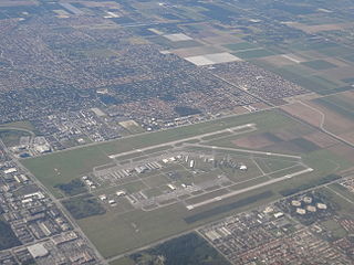
Central Wisconsin Airport, referred to as "C-Way", is a public airport located 3 nautical miles southeast of the central business district of Mosinee, in Marathon County, Wisconsin, United States. It is owned by Marathon County and Portage County. It is included in the Federal Aviation Administration (FAA) National Plan of Integrated Airport Systems for 2023–2027, in which it is categorized as a non-hub primary commercial service facility. It is the fifth busiest of eight commercial airports in Wisconsin in terms of passengers served.

Shelby County Airport is a public use airport located four nautical miles (7 km) southeast of the central business district of Alabaster, a city in Shelby County, Alabama, United States. It is owned by the Shelby County Commission. The airport is situated in the city of Calera.

Merrill Field is a public-use general aviation airport located one mile (1.6 km) east of downtown Anchorage in the U.S. state of Alaska. The airport is owned by Municipality of Anchorage. It opened in 1930 as Anchorage Aviation Field and was renamed in honor of Alaska aviation pioneer Russel Merrill.

Jacqueline Cochran Regional Airport is a county-owned, public-use airport in Riverside County, California, United States. It is located in the southeastern Coachella Valley, 20 nautical miles southeast of the central business district of Palm Springs, in Thermal, California. This airport is included in the National Plan of Integrated Airport Systems for 2011–2015, which categorized it as a general aviation facility.

Chino Airport is a county-owned airport about three miles southeast of Chino, in San Bernardino County, California, United States. The Federal Aviation Administration's National Plan of Integrated Airport Systems for 2007–2011 classified it as a reliever airport, due to its proximity to the Ontario International Airport and the John Wayne Airport.
Abrams Municipal Airport is a city-owned, public-use airport located two nautical miles (3.7 km) north of the central business district of Grand Ledge, a city in Eaton County, Michigan, United States. It is included in the Federal Aviation Administration (FAA) National Plan of Integrated Airport Systems for 2017–2021, in which it is categorized as a local general aviation facility.

Grayling Army Airfield is a public/military use airport located one nautical mile (1.85 km) northwest of the central business district of Grayling, in Crawford County, Michigan, United States. It is owned by United States Army. The airfield is located 7 miles (11 km) northeast of the main cantonment area of Camp Grayling. It is included in the Federal Aviation Administration (FAA) National Plan of Integrated Airport Systems for 2017–2021, in which it is categorized as a general aviation facility.

Treasure Coast International Airport is a public airport located three miles (5 km) northwest of the central business district of Fort Pierce, a city in St. Lucie County, Florida, United States. It is owned by the St. Lucie Board of County Commissioners.
Ridge Soaring Gliderport was a public-use glider airport located two nautical miles (4 km) southwest of the central business district of Unionville, in Centre County, Pennsylvania, United States. It was privately owned by Knauff & Grove, Inc.

Lake County Airport, also known as Leadville Airport, is a county-owned public-use airport located two nautical miles (3.7 km) southwest of the central business district of Leadville, a city in Lake County, Colorado, United States.

Perry–Houston County Airport is a public airport located four miles (6 km) northwest of the central business district of Perry, a city in Houston County, Georgia, United States and 10 miles (16 km) south of Warner Robins, Georgia. It is owned by the Perry–Houston County Airport Authority. It is used for general aviation, mainly flight training.

Dalhart Municipal Airport is in unincorporated Hartley County, Texas, three miles (5 km) southwest of Dalhart, Texas, a city straddling the border of Dallam and Hartley counties in the northwest corner of the Texas Panhandle.

DeLand Municipal Airport, also known as Sidney H. Taylor Field, is a city-owned public-use airport located three nautical miles (5 km) northeast of the central business district of DeLand, a city in Volusia County, Florida, United States.

Kissimmee Gateway Airport, formerly known as Kissimmee Municipal Airport, is a public airport in Kissimmee, a city in Osceola County, Florida, United States. The airport is located 16 nautical miles (30 km) southwest of the central business district of Orlando. It is owned and operated by the City of Kissimmee.
Flagler Executive Airport (ICAO: KFIN, FAA LID: FIN) is a county-owned public-use airport located three miles (5 km) east of the central business district of Bunnell, a city in Flagler County, Florida, United States. The airport's former FAA location identifiers were X47 and XFL. The airfield was originally constructed by the United States Navy during World War II as Naval Outlying Field Bunnell (NOLF Bunnell), an auxiliary airfield for flight training operations originating from nearby Naval Air Station Jacksonville, NAS Daytona Beach and NAS DeLand. Following the end of the war, the airfield was transferred from the Navy to Flagler County for use as a general aviation airport.

Conroe-North Houston Regional Airport is a public-use airport in Conroe, Texas, United States, 37 miles (60 km) north of the central business district of Houston. It is publicly owned by Montgomery County.

La Junta Municipal Airport is three miles north of La Junta, in Otero County, Colorado, United States. The National Plan of Integrated Airport Systems for 2011–2015 categorized it as a general aviation facility.
Colorado Springs East Airport is a private airport located 25 miles (40 km) east of the central business district of the city of Colorado Springs, and 3 miles (4.8 km) northwest of the central business district of the city of Ellicott in El Paso County, Colorado, United States. The airport is privately owned by Springs East Airport, Inc. The airport is 2 miles (3.2 km) north of Highway 94 via a gravel road, and taxiways and vehicle roadways are gravel/grass/dirt.
