Dover is a city in Strafford County, New Hampshire, United States. The population was 32,741 at the 2020 census, making it the most populous city in the New Hampshire Seacoast region and the fifth most populous city in New Hampshire.

Yarmouth is a town in Cumberland County, Maine, United States, twelve miles north of the state's largest city, Portland. When originally settled in 1636, as North Yarmouth, it was part of the Massachusetts Bay Colony, and remained part of its subsequent incarnations for 213 years. In 1849, twenty-nine years after Maine's admittance to the Union as the twenty-third state, it was incorporated as the Town of Yarmouth.
The historical buildings and structures of Yarmouth, Maine, represent a variety of building styles and usages, largely based on its past as home to almost sixty mills over a period of roughly 250 years. These mills include that of grain, lumber, pulp and cotton. Additionally, almost three hundred vessels were launched by Yarmouth's shipyards in the century between 1790 and 1890, and the homes of master shipwrights and ship captains can still be found throughout the town.

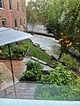
Royal River Park is an urban park in Yarmouth, Maine, United States. It is located to the northwest of the town center, between East Elm Street to the west and Bridge Street to the east. U.S. Route 1 runs through the park via an overpass.

Christian Hayes is a chef and restaurateur from Portland, Maine, United States. Between 2019 and 2024, he was the owner and executive chef at The Garrison, a restaurant in Yarmouth, Maine. He was the winner of Food Network's Chopped episode "Pork on the Brain" in March 2018.
George Warren Hammond was an American businessman. Camp Hammond, in Yarmouth, Maine, is named for him. He was also one of its architects. Built in 1889, it was placed on the National Register of Historic Places in 1979.
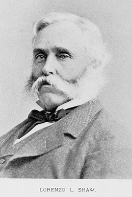
Lorenzo L. Shaw, commonly known as L. L. Shaw, was an American businessman who was active in coastal North Yarmouth, Massachusetts, in the 19th century. He was the co-founder of Freeman, Shaw & Co., a cotton mill, and of Pumgustuk Water Company.

Forest Paper Company was a pulp and paper mill on the Royal River in Yarmouth, Maine, United States, which was in business between 1874 and 1923. It was the first of its kind in New England. In 1909, it was the largest such mill in the world, employing 275 people. It produced 80 tons of poplar pulp each day.
Eleazer Burbank was a 19th-century American physician and legislator in the State of Maine.
H. J. Libby & Company was a textile firm based in Portland, Maine, and New York City, United States. In 1854, it was listed as a selling agent for dress goods. It became one of the oldest woolen commission businesses in the United States.
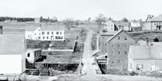
Bridge Street is a historic street in Yarmouth, Maine, United States. It runs for about 0.36 miles (0.58 km) from Willow Street in the north to the town's Main Street, State Route 115, in the south. The street's elevation is around 75 feet (23 m) at each end, while its middle section, at its crossing of the Royal River, is around 13 feet (4.0 m), a drop of around 62 feet (19 m).
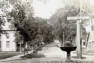
Elm Street is a prominent street in Yarmouth, Maine, United States. It runs for about 2.7 miles (4.3 km) from North Road in the north to Portland Street in the south. The street's addresses are split between "West Elm Street" and "East Elm Street", the transition occurring at Main Street in the Upper Village. Several of its buildings are homes dating to the late 18th and early 19th centuries.

The First Falls are the first of four waterfalls in Yarmouth, Maine, United States. They are located on the Royal River, approximately a mile from its mouth with inner Casco Bay at Yarmouth Harbor and around 0.35 miles (0.56 km) downstream of the Second Falls. The river appealed to settlers because its 45-foot rise in close proximity to navigable water each provided potential waterpower sites. As such, each of the four falls was used to power 57 mills between 1674 and the mid-20th century.

The Second Falls are the second of four waterfalls in Yarmouth, Maine, United States. They are located on the Royal River, approximately 1.35 miles (2.17 km) from its mouth with inner Casco Bay at Yarmouth Harbor, and approximately 0.35 miles (0.56 km) upstream of the First Falls. The river appealed to settlers because its 45-foot rise in close proximity to navigable water each provided potential waterpower sites. As such, each of the four falls was used to power 57 mills between 1674 and the mid-20th century.

The Third Falls are the third of four waterfalls in Yarmouth, Maine, United States. They are located on the Royal River, approximately 2.8 miles (4.5 km) from its mouth with inner Casco Bay at Yarmouth Harbor, and approximately 0.4 miles (0.64 km) upstream of the Second Falls. The river appealed to settlers because its 45-foot rise in close proximity to navigable water each provided potential waterpower sites. As such, each of the four falls was used to power 57 mills between 1674 and the mid-20th century.

The Fourth Falls, also known as Upper Falls or Gooch's Falls, are the fourth of four waterfalls in Yarmouth, Maine, United States. They are located on the Royal River, approximately 0.4 miles (0.64 km) upstream of the Third Falls. The river appealed to settlers because its 45-foot rise in close proximity to navigable water each provided potential waterpower sites. As such, the four falls were used to power 57 mills between 1674 and the mid-20th century.

Fort Andross, also known as Fort George and Cabot Mill, was initially established as a trading post and later converted into a historic garrison by the colonial British Empire as a defensive measure against the Wabanaki Native Americans who were allied with France during King William's War (1688–1697). It was situated next to Brunswick Falls, on the Androscoggin River in Brunswick, Maine. During the war, the fortification was destroyed, rebuilt, and renamed Fort George in 1715. Once the Native American wars came to an end, the fort was abandoned.

Portland and Yarmouth Electric Railway was an electric trolleycar service that ran along the coast between Portland and Yarmouth, Maine, from 1898 and 1933. Described in 1901 as the "new electric road", Yarmouth was "now a closer neighbor [to Portland] than ever before" because of the railway's advent.

Lower Falls is the colloquial name for the eastern end of Main Street, and part of East Main Street, in Yarmouth, Maine, centered around Main Street's intersection with Portland Street. It is also known as Falls Village or The Falls.

Yarmouth Water District (YWD) is a water company which serves Yarmouth, Maine, United States. It was established in 1887 as Pumgustuk Water Company. Its founders were Lorenzo L. Shaw, Charles H. Weston, John H. Humphrey, Joseph Y. Hodsdon, E. Dudley Freeman and George W. Hammond. Weston owned a machine shop and foundry at the Fourth Falls in Yarmouth, near where the water company was based. The company sourced its water supply from Hammond Spring on the property of Forest Paper Company. Hammond Spring was named for George W. Hammond, founder of Forest Paper Company and early president of Yarmouth Water Committee, the successor to Pumgustuk Water Company. Hammond built Camp Hammond in Yarmouth in 1889. It was added to the National Register of Historic Places in 1979.