
St. Jacobs is an unincorporated suburban community in the township of Woolwich in Waterloo Regional Municipality, Ontario, Canada. It is located north of the city of Waterloo. It is a popular location for tourism, due to its quaint appearance, retail focus, and Mennonite heritage. Waterloo Region is still home to the largest population of Old Order Mennonites in Canada, particularly in the areas around St Jacobs and Elmira. They are often seen on the local roads using their traditional horse and buggy transportation; many also use horses to pull the implements in their farm fields.

Flamborough is a district and former municipality in the city of Hamilton, Ontario, Canada. For most of its existence before amalgamation with Hamilton in 2001, Flamborough comprised the former townships of East Flamborough, West Flamborough, and Beverly, as well as the village of Waterdown. The largest suburban community is the former village of Waterdown containing perhaps one third of its thirty thousand or so inhabitants. Other Flamborough communities include Carlisle, Christie's Corners, Clappison's Corners, Copetown, Freelton, Greensville, Lynden, Kirkwall, Millgrove, Mountsberg, Orkney, Peters Corners, Rockton, Troy, Sheffield, Valens, Strabane and Westover.

New Fort York, later the Stanley Barracks, is a former British and Canadian military base in Toronto, Ontario, Canada, located on the Lake Ontario shoreline. It was built in 1840–1841 to replace Toronto's original Fort York at the mouth of Garrison Creek as the primary military base for the settlement. Unlike the older fort, many of the new fort buildings were made with limestone instead of wood. A protective wall was planned for the new fort but was never built. The fort was used by the British army until 1870, and the Canadian military subsequently used the fort to train troops for the Second Boer War, World War I and World War II. It also trained one of the first regiments of the North-West Mounted Police. The Canadian military stopped using it after World War II and the fort was demolished in the 1950s. Only the Officers' Quarters building remains on the site.
The Walkerton E. coli outbreak was the result of a contamination of the drinking water supply of Walkerton, Ontario, Canada, with E. coli and Campylobacter jejuni bacteria. The water supply was contaminated as a result of improper water treatment following heavy rainfall in late April and early May 2000, that had drawn bacteria from the manure of nearby cattle used to fertilize crops into the shallow aquifer of a nearby well. The first reported case was on May 17. The contamination caused gastroenteritis and sickened more than 2,000 people and resulted in seven deaths.
Highbury Avenue is an arterial road located in the Canadian province of Ontario. In addition to serving as a primary north–south thoroughfare in eastern London – through which part of it is a limited-access freeway – the road also provides access to Highway 401 and continues south to St. Thomas. The southern terminus of Highbury Avenue is an intersection with South Edgeware Road, just north of Highway 3 and the eastern end of the St. Thomas Expressway. From there, it travels 45.6 kilometres (28.3 mi) north to Highway 7, east of Elginfield. Outside of London and St. Thomas, the road also passes through the communities of Ballymote and Bryanston. It is designated as Elgin County Road 30 within Central Elgin, and as Middlesex County Road 23 within Middlesex Centre, the two rural municipalities through which the route passes.
King's Highway 5, commonly referred to as Highway 5 and historically as the Dundas Highway and Governor's Road, is a provincially maintained highway in the Canadian province of Ontario. The east–west highway travels a distance of 12.7 km (7.9 mi) between Highway 8 at Peters Corners, north of Hamilton, and Highway 6 at Clappison's Corners. Prior to several sections being downloaded to the municipalities in which they were located, Highway 5 served as bypass to Highway 2, connecting with it in both Paris and Toronto, a distance of 114.3 km (71.0 mi).

Ōwairaka is a suburb of New Zealand's largest city, Auckland. It is under the local governance of the Auckland Council. The area was primarily rural until the 1930s, when the area experienced suburban growth. Ōwairaka is known for the Owairaka Athletic Club, a club that came to prominence in the 1960s, due to the success of coach Arthur Lydiard and athletes Murray Halberg and Peter Snell.

Kelso Conservation Area is located near Milton, Ontario on the Niagara Escarpment and is owned and operated by Conservation Halton. This park has an area of 3.97 square kilometres and contains Lake Kelso which was built for flood control of Sixteen Mile Creek and has a sandy beach for swimmers in the summer with a food concession and board walk along the lake to the Boat Rental shop which offers the rentals of canoes, kayaks, paddle boards, paddle boats and is also open to any non-motorized watercraft. The Park also offers 20 campsites, 18 reserve-able picnic sites, and two camping/picnic mixed sites. Glen Eden Ski & Snowboard Centre is located in the park and offers downhill skiing, snowboarding and tubing during the winter months. In addition, the Halton Region Museum is also located on the Kelso grounds. The park also features marked mountain biking and hiking trails.
The Hamilton Conservation Authority maintains the greenspace, trails, parks and some attractions in Hamilton, Ontario, Canada.
Cootes Drive, formerly known as the Dundas Diversion, is a city street in Hamilton, Ontario. The route connects York Road and King Street in Dundas with Main Street to the southeast, and is considered one of the first divided highways in Canada. Originally constructed as the Dundas Diversion, the route served to bypass several sharp turns along the nearby Highway 8, as well as to demonstrate the new dual highway concept that would soon thereafter evolve into the 400-series highway network. Construction began in 1936, and the route opened on the weekend of September 11, 1937.
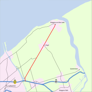
King's Highway 55, commonly referred to as Highway 55 and historically as the Niagara Stone Road and Black Swamp Road, was a provincially maintained highway in the Canadian province of Ontario, which connected the Queen Elizabeth Way (QEW) with Niagara-on-the-Lake, following Niagara Stone Road. The route divided a swath of wineries at the foot of the Niagara Escarpment, passing at an oblique angle to the concession road grid.

Spencer Gorge/Webster's Falls Conservation Area is located on the Niagara Escarpment in Dundas, Ontario, a constituent community of Hamilton, Ontario, and is owned and operated by the Hamilton Conservation Authority. It has views over Hamilton and a two major waterfalls that are accessible via a system of trails. The natural features found in the area are considered to be provincially significant. A shuttle service runs from Christie Lake Conservation Area to Spencer Gorge/Webster Falls Conservation Area, for visitors to access this conservation area on weekends and holidays.

Tourism in Belize has grown considerably recently, and it is now the second largest industry in the nation. Belizean Prime Minister Dean Barrow has stated his intention to use tourism to combat poverty throughout the country. The growth in tourism has positively affected the agricultural, commercial, and finance industries, as well as the construction industry. The results for Belize's tourism-driven economy have been significant, with the nation welcoming almost one million tourists in a calendar year for the first time in its history in 2012.
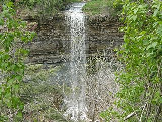
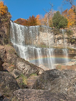
Borer's Falls is a 15-metre-high (49 ft) ribbon-style waterfall found in the Borer's Falls Conservation Area in Dundas, Hamilton, Ontario, Canada. Its source is Borer's Creek. A very picturesque waterfall featured on many Hamilton waterfall postcards over the years. Named after the Borer family who ran a sawmill for over a century. This mill was the lifeblood of the village of Rock Chapel. Also known as Rock Chapel Falls. The area is a hiker's haven and also an ice-climbing destination in the winter when the weather is cold enough to freeze the Falls.

Darnley Cascade is a 4-metre-high (13 ft) cascade waterfall located at Crooks Hollow Conservation Area in Greensville, Hamilton, Ontario, Canada. Nearby attractions include Bruce Trail, Dundas Valley Conservation Area, Spencer Gorge/Webster's Falls Conservation Area, Hermitage ruins, Royal Botanical Gardens, Dundurn Castle, Christie Lake Conservation Area, Dundas Historical Society Museum and Carnegie Gallery.

Nako is a village in the Himalayas of northern India, located near the Indo-China border in the Trans-Himalayan region of Kinnaur district in Himachal Pradesh. Nako Lake is a prominent feature here where it borders the village. Nako Monastery, dated to 1025, is located in the village as well as several other Buddhist chortens.
The history of the San Fernando Valley from its exploration by the 1769 Portola expedition to the annexation of much of it by the City of Los Angeles in 1915 is a story of booms and busts, as cattle ranching, sheep ranching, large-scale wheat farming, and fruit orchards flourished and faded. Throughout its history, settlement in the San Fernando Valley was shaped by availability of reliable water supplies and by proximity to the major transportation routes through the surrounding mountains.
Valens is a community in Ontario in the city of Hamilton. It is the location of the Valens Conservation Area, which is built around the Valens Reservoir.

Sheila Varian was an American breeder of Arabian horses who lived and worked at the Varian Arabians Ranch near Arroyo Grande, California. She grew up with a strong interest in horses, and was mentored in horsemanship by Mary "Sid" Spencer, a local rancher and Morgan horse breeder who also introduced Varian to the vaquero or "Californio" tradition of western riding. She started her horse ranch, Varian Arabians, in 1954 with the assistance of her parents. Raising and training horses was her full-time occupation beginning in 1963. She used vaquero-influenced methods of training horses, although she adapted her technique over the years to fit the character of the Arabian horse, which she viewed as a horse breed requiring a smart yet gentle approach.

Vientiane Prefecture is a prefecture of Laos, in the northwest Laos. The national capital, Vientiane, is in the prefecture. The prefecture was created in 1989, when it was split off from Vientiane province.

