Spook (crater)

Last updated
Spook
Flag crater Spook crater AS16-P-4618 ASU.jpg
Apollo 16 image, with Flag left of center and Spook right of center. Buster is the small crater north of Spook.
Coordinates 8°59′S15°29′E / 8.98°S 15.48°E / -8.98; 15.48
Diameter 340 m [1]
Eponym Astronaut-named feature

Spook crater is a small crater in the Descartes Highlands of the Moon visited by the astronauts of Apollo 16. The name of the crater was formally adopted by the IAU in 1973. [1] Geology Station 2 is adjacent to Spook, between it and the smaller, younger crater called Buster to the north of it.

Contents

On April 21, 1972, the Apollo 16 Lunar Module Orion landed about 500 m east of Spook, which is between the prominent North Ray and South Ray craters. The astronauts John Young and Charles Duke explored the area over the course of three EVAs using a Lunar Roving Vehicle, or rover. They stopped at Spook during EVA 1, on the way back to the LM from Flag crater.

Spook crater is approximately 340 m in diameter and over 20 m deep. [2] Spook is about 550 m west of the landing site itself. The small, fresh crater called Buster is north of Spook. Many samples were collected at the south rim of Buster.

The Lunar Portable Magnetometer (LPM) was used to obtain a reading of approximately 180 γ (gamma) at Spook. [3] This was one of five locations at the landing site where the LPM was used.

Spook cuts into the Cayley Formation of Imbrian age. [4]

Samples

Planimetric map of Station 2 from the Apollo 16 Preliminary Science Report. X indicates sample locations, 5-digit numbers are LRL sample numbers, rectangle is the Lunar Roving Vehicle (dot indicates TV camera), black spots are large rocks, dashed lines are crater rims or other topographic features, and triangles are panorama stations. LPM is the location of the Lunar Portable Magnetometer reading. Apollo 16 PSR Figure 6-29 Planimetric map of Station 2.jpg
Planimetric map of Station 2 from the Apollo 16 Preliminary Science Report. X indicates sample locations, 5-digit numbers are LRL sample numbers, rectangle is the Lunar Roving Vehicle (dot indicates TV camera), black spots are large rocks, dashed lines are crater rims or other topographic features, and triangles are panorama stations. LPM is the location of the Lunar Portable Magnetometer reading.
TV camera still of Charlie Duke's "juggling act" trying to catch sample 62275 at the rim of Buster crater. The sample is to the right of his helmet and above his outstretched hands. Charlie Duke Buster crater juggling.jpg
TV camera still of Charlie Duke's "juggling act" trying to catch sample 62275 at the rim of Buster crater. The sample is to the right of his helmet and above his outstretched hands.

The following samples were collected from the vicinity of Buster crater (Station 2), as listed in Table 6-II of the Apollo 16 Preliminary Science Report, [3] which does not include samples smaller than 25 g weight (of which there were many). Sample type, lithology, and descriptions are from the Lunar Sample Atlas of the Lunar and Planetary Institute. [5]

SampleSample TypeLithologyIn-situ PhotoPhotoDescription
62235rake breccia AS16-109-17837 (21657749386).jpg Lunar sample 62235 S72-38384.jpg apparently homogeneous, coherent, hollocrystaline impact melt rock with classic poikilitic texture highly enriched in trace elements and siderophile elements and has been dated at 3.88 b.y., with an exposure history of 153 m.y.
62236rakerock AS16-109-17837 (21657749386).jpg Lunar sample 62236 S72-38954.jpg found to be a slowly-cooled plutonic rock (Takeda et al. 1979) with an age of ~4.3 b.y. (Borg et al. 1999).
62237rock anorthite AS16-109-17837 (21657749386).jpg Lunar sample 62237 S72-38960.jpg chalky white rock
62255rockbreccia AS16-109-17843 (21672394862).jpg Lunar sample 62255 S72-38309.jpg has been crushed and granulated by shock and is penetrated with patches and veins of mafic melt
62275rockanorthite AS16-109-17845 (21061135134).jpg Lunar sample 62275 S72-38389.jpg very friable, chalky white rock that broke up into powder during handling in curatorial labs and has not been adequately studied.
62295rakeimpact melt breccia AS16-109-17847 (21683812955).jpg Lunar sample 62295 S72-38395.jpg blocky coherent impact melt rock with numerous micrometeorite pits on one side and none on the other

Related Research Articles

<span class="mw-page-title-main">Apollo 16</span> Fifth crewed Moon landing

Apollo 16 was the tenth crewed mission in the United States Apollo space program, administered by NASA, and the fifth and penultimate to land on the Moon. It was the second of Apollo's "J missions", with an extended stay on the lunar surface, a focus on science, and the use of the Lunar Roving Vehicle (LRV). The landing and exploration were in the Descartes Highlands, a site chosen because some scientists expected it to be an area formed by volcanic action, though this proved not to be the case.

<span class="mw-page-title-main">Descartes Highlands</span> Highlands on Earths Moon

The Descartes Highlands is an area of lunar highlands located on the near side that served as the landing site of the American Apollo 16 mission in early 1972. The Descartes Highlands is located in the area surrounding Descartes crater, after which the feature received its name.

<span class="mw-page-title-main">North Ray (crater)</span> Crater on the Moon

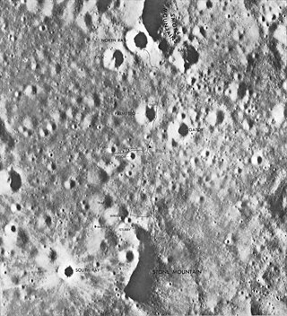
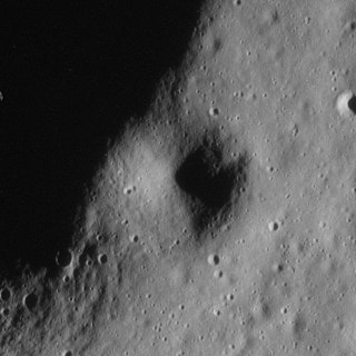
North Ray crater is a small crater in the Descartes Highlands of the Moon visited by the astronauts of Apollo 16. The name of the crater was formally adopted by the IAU in 1973. It is the largest crater sampled by astronauts during the Apollo program.

<span class="mw-page-title-main">South Ray (crater)</span> Crater on the Moon

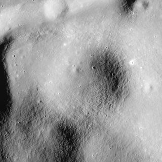
South Ray crater is a small crater in the Descartes Highlands of the Moon photographed from the lunar surface by the astronauts of Apollo 16. The name of the crater was formally adopted by the IAU in 1973.

<span class="mw-page-title-main">Palmetto (crater)</span> Crater on the Moon

Palmetto crater is a small crater in the Descartes Highlands of the Moon visited by the astronauts of Apollo 16. The name of the crater was formally adopted by the IAU in 1973.

<span class="mw-page-title-main">Camelot (crater)</span> Lunar impact crater

Camelot is a feature on Earth's Moon, a crater in Taurus-Littrow valley. Astronauts Eugene Cernan and Harrison Schmitt visited it in 1972, on the Apollo 17 mission, during EVA 2. Geology Station 5 was along the south rim of Camelot.

<span class="mw-page-title-main">Victory (crater)</span> Crater on the Moon

Victory is a feature on Earth's Moon, a crater in Taurus–Littrow valley. Astronauts Eugene Cernan and Harrison Schmitt visited it in 1972, on the Apollo 17 mission, during EVA 2. The astronauts stopped at the south rim of Victory on their way back to the Lunar Module from Shorty crater.

<span class="mw-page-title-main">Van Serg (crater)</span> Crater on the Moon

Van Serg is a feature on Earth's Moon, a crater in Taurus–Littrow valley. Astronauts Eugene Cernan and Harrison Schmitt visited it in 1972, on the Apollo 17 mission, during EVA 3. Van Serg was designated Geology Station 9.

<span class="mw-page-title-main">Lara (lunar crater)</span> Crater on the Moon

Lara is a feature on Earth's Moon, a crater in Taurus-Littrow valley. Astronauts Eugene Cernan and Harrison Schmitt visited it in 1972, on the Apollo 17 mission, during EVA 2. Geology Station 3 of the mission is located on the northeast rim of Lara.

<span class="mw-page-title-main">Cochise (crater)</span> Lunar impact crater in the Taurus–Littrow valley

Cochise is a feature on Earth's Moon, a crater in Taurus-Littrow valley. Astronauts Eugene Cernan and Harrison Schmitt landed southwest of it in 1972, on the Apollo 17 mission. They drove along its rim in the rover during EVA 3, but did not stop.

<span class="mw-page-title-main">Trident (crater)</span> Crater on the Moon

Trident is a feature on Earth's Moon, a crater in Taurus-Littrow valley. Astronauts Eugene Cernan and Harrison Schmitt landed about 300 m north of its rim in 1972, on the Apollo 17 mission. They drove along the east rim of Trident during EVA 1 of the mission, in their rover.

<span class="mw-page-title-main">Spur (lunar crater)</span> Surface depression on the Moon

Spur is a feature on Earth's Moon, a crater in the Hadley–Apennine region. Astronauts David Scott and James Irwin visited it in 1971, on the Apollo 15 mission, during EVA 2. Spur was designated Geology Station 7.

<span class="mw-page-title-main">Dune (crater)</span> Crater on the Moon

Dune is a feature on Earth's Moon, a crater in the Hadley–Apennine region. Astronauts David Scott and James Irwin visited the south rim of it in 1971, on the Apollo 15 mission, during EVA 2. The south rim of Dune was designated Geology Station 4 of the mission.

<span class="mw-page-title-main">Flag (crater)</span> Lunar crater explored on Apollo 16

Flag crater is a small crater in the Descartes Highlands of the Moon visited by the astronauts of Apollo 16. The name of the crater was formally adopted by the IAU in 1973. Geology Station 1 is adjacent to Flag, at the much smaller Plum crater.

<span class="mw-page-title-main">Elbow (lunar crater)</span> Crater on the Moon

Elbow is a feature on Earth's Moon, a crater in the Hadley–Apennine region. Astronauts David Scott and James Irwin visited the east rim of it in 1971, on the Apollo 15 mission, during EVA 1. The east rim of Elbow was designated Geology Station 1 of the mission. Geology Station 2 was to the southwest of the crater, up the slope of Mons Hadley Delta.

<span class="mw-page-title-main">St. George (crater)</span> Crater on the Moon

St. George is a feature on Earth's Moon, a crater in the Hadley–Apennine region. Astronauts David Scott and James Irwin drove their rover onto what was suspected to be its ejecta blanket in 1971, on the Apollo 15 mission, during EVA 1. They collected samples to the northeast of the crater, at Geology Station 2 of the mission.

<span class="mw-page-title-main">Cinco (crater)</span> Crater on the Moon

Cinco is a small crater in the Descartes Highlands of the Moon visited by the astronauts of Apollo 16. The crater is one of a group of five (hence the name, Spanish for five) craters that were collectively called the Cinco craters during the Apollo 16 mission. The craters were designated a, b, c, d, and e, and the largest (a) was officially named Cinco after the mission in 1973 by the IAU.

<span class="mw-page-title-main">Surveyor (crater)</span> Crater on the Moon

Surveyor crater is a small crater in Oceanus Procellarum on the Moon. The name of the crater was formally adopted by the IAU in 1973.

<span class="mw-page-title-main">Head (crater)</span> Crater on the Moon

Head crater is a small crater in Oceanus Procellarum on the Moon. The name of the crater was formally adopted by the IAU in 1973.

<span class="mw-page-title-main">Cone (crater)</span> Crater on the Moon

Cone crater is a small crater in the Fra Mauro highlands, north of Fra Mauro crater, on the Moon. The name of the crater was formally adopted by the IAU in 1973.
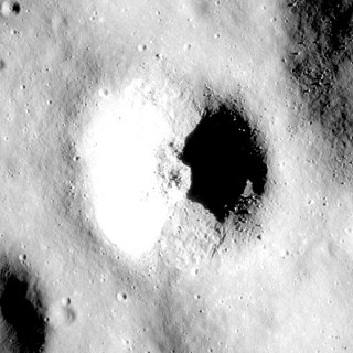
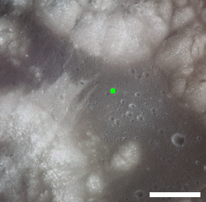
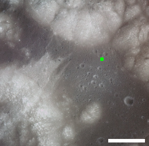
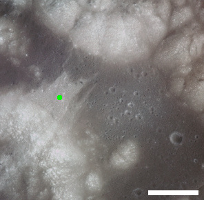
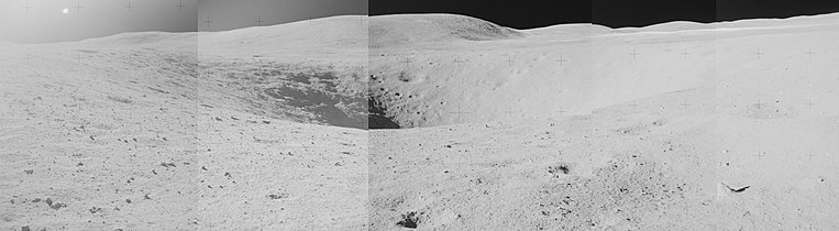
References

  1. 1 2 Spook, Gazetteer of Planetary Nomenclature, International Astronomical Union (IAU) Working Group for Planetary System Nomenclature (WGPSN)
  2. Apollo 16 Landing Area, 78D2S1(50), NASA Lunar Topophotomap. Published by The Defense Mapping Agency, November 1974. Available from Lunar and Planetary Institute.
  3. 1 2 Apollo 16 Preliminary Science Report (NASA SP-315), 1972
  4. Geologic Map of the Apollo 16 (Descartes) Landing Area by Apollo Field Geology Investigation Team (D. P. Elston, E. L. Boudette, J. P. Schafer), United States Geological Survey, April 1972
  5. Lunar Sample Atlas, Lunar and Planetary Institute