In 1856, John Spoon and his brother, Daniel, arrived in this location and constructed a sawmill. Eventually a small town, Spoonville, grew up around the site, and in 1871, was established as a station on the Chicago and Michigan Lake Shore Railroad. Spoon discovered three mounds on his property.[4] One of these, reportedly 100ft (30m) long and 15ft (4.6m) high, was destroyed in the construction of the sawmill.[5]
Archaeology
The site, located on a terrace between Crockery Creek and the Grand River,[6] was the location of a large Middle Woodland period village and burial mound complex.[7]
The first archaeological investigation of the site was conducted by Able Anderson in 1857. Anderson excavated one of the mounds, reporting human remains and other artifacts.[8] In 1876, William D. Gunning carried out further excavation at the site.[4] More recent excavations were conducted in 1962, and excavation of the village at the site continued through the next few decades.[8]
Gallery
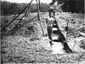
Spoonville archaeological site - trenching in 1962
Spoonville archaeological site - burial map of mound 2
Spoonville archaeological site - 1969 excavation, copper, fint, and mica artifacts
Spoonville archaeological site - artifacts from early excavations housed at Field Museum
References
↑ The Spoonville Site is listed by the NRIS as "Address Restricted." However, the Ottawa County Park System gives the general location (Marjorie Bethke Viveen, Historic River Road: A Self-Guided Auto Tour for all Seasons(PDF), Ottawa County Parks). Geo-coordinates are approximate.
This page is based on this Wikipedia article Text is available under the CC BY-SA 4.0 license; additional terms may apply. Images, videos and audio are available under their respective licenses.