
Somerville is a city located directly to the northwest of Boston, and north of Cambridge, in Middlesex County, Massachusetts, United States. As of the 2020 United States Census, the city had a total population of 81,045 people. With an area of 4.12 square miles (10.7 km2), the city has a density of 19,671/sq mi (7,595/km2), making it the most densely populated municipality in New England and the 16th most densely populated incorporated municipality in the country. Somerville was established as a town in 1842, when it was separated from Charlestown. In 2006, the city was named the best-run city in Massachusetts by The Boston Globe. In 1972, 2009, and 2015, the city received the All-America City Award. It is home to Tufts University, which has its campus along the Somerville and Medford border.
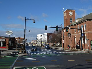
Union Square is a neighborhood in the southeastern part of Somerville, Massachusetts. It is centered on Union Square proper, which is located at the intersection of Washington Street, Webster Avenue, and Somerville Avenue.

The Round House is a cylindrical, wood-frame residential building at 36 Atherton Street in the Spring Hill neighborhood of Somerville, Massachusetts, United States. It was built in 1856 by hardware manufacturer Enoch Robinson, and is considered an offshoot of the octagon house-style popularized by phrenologist Orson Fowler.

Neighborhoods in Spokane, Washington are officially grouped by the Spokane City Council into three main city council districts: 1, 2, and 3. Each city council district contains multiple, official neighborhoods that are recognized with a neighborhood council. Informally, neighborhoods are colloquially grouped by local geographical, geological, cultural, or historical features The list of neighborhoods below is organized based on the official designations by the City of Spokane. Unofficial neighborhoods and districts are listed within the official neighborhood in which they are located.

Powder House Square is a neighborhood and landmark rotary in Somerville, Massachusetts, United States. It is also known locally as Powder House Circle. It is the 6-way intersection of College Avenue, Broadway, Warner Street, and Powder House Boulevard. Powder House Square stands at the southern tip of Tufts University's main Somerville/Medford campus, and borders the northern edge of Nathan Tufts Park. The square takes its name from the 18th century Powder House which overlooks the rotary from Nathan Tufts Park.

The Boston–Edison Historic District is a historic neighborhood located in the geographic center of Detroit, Michigan. It consists of over 900 homes built on four east/west streets: West Boston Boulevard, Chicago Boulevard, Longfellow Avenue, and Edison Avenue, stretching from Woodward Avenue on the east to Linwood Avenue on the west. It is one of the largest residential historic districts in the nation. It is surrounded by Sacred Heart Major Seminary to the west, the Arden Park-East Boston Historic District and the Cathedral of the Most Blessed Sacrament to the east, and the Atkinson Avenue Historic District to the south. The district was designated a Michigan State Historic Site in 1973 and listed on the National Register of Historic Places in 1975.
The Old Dauphin Way Historic District is a historic district in the city of Mobile, Alabama, United States. It was named for Dauphin Way, now known as Dauphin Street, which bisects the center of the district from east to west. The district is roughly bounded by Broad Street on the east, Springhill Avenue on the north, Government Street on the south, and Houston Avenue on the west. Covering 766 acres (3.10 km2) and containing 1466 contributing buildings, Old Dauphin Way is the largest historic district in Mobile.

Mount Pleasant Historic District is a historic district encompassing a cluster of well-preserved 19th-century residential buildings on Forest Street and Mount Pleasant Avenue in the Roxbury neighborhood of Boston, Massachusetts. First developed in 1833, it was one Roxbury's first speculative residential subdivision developments. The district features Greek Revival, Italianate, and Romanesque architecture, and was added to the National Register of Historic Places in 1989.
The Silver Hill Historic District encompasses the first major residential subdivision of Weston, Massachusetts. It includes 79 buildings on Silver Hill and Westland Roads, and Merriam Street. The area of Silver Hill and Westland Roads was formally laid out in 1905, while Merriam Street is a very old country road which had seen some development in the 1890s. The houses in the district are predominantly Colonial Revival and Queen Anne in their styling, a relative rarity in Weston although common in other Boston suburbs. The district was added to the National Register of Historic Places in 2004.

The Charles Adams-Woodbury Locke House is an historic house in Somerville, Massachusetts. The Greek Revival house was built about 1840 for a Boston leather merchant and was one of the first residences of a commuter, rather than a farmer, in the Winter Hill neighborhood of the city. The house was listed on the National Register of Historic Places in 1989.

The Martin W. Carr School is a historic school building located at 25 Atherton Street, in the Spring Hill area of Somerville, Massachusetts. Built in 1898, it is a prominent local example of Colonial and Renaissance Revival architecture, and the only known surviving work of local architect Aaron H. Gould. It served the local neighborhood as a school until 1980, and was subsequently converted into condominiums. It was listed on the National Register of Historic Places in 1984.

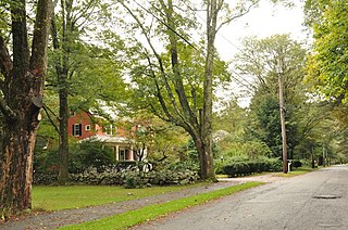
The Spring Hill Historic District is a historic district roughly bounded by Summer, Central, Atherton, and Spring Streets in the Spring Hill area of Somerville, Massachusetts. The district encompasses the city's best-preserved residential subdivision from the mid-19th century, with later infill construction in the late 19th and early 20th centuries. The district was listed on the National Register of Historic Places in 1989.

26 Center Avenue in Reading, Massachusetts is an architecturally eclectic cottage, with a mix of Greek Revival, Gothic Revival, and Italianate features. Built c. 1854–1875, it is a rare surviving remnant of a residential subdivision once dubbed "Mudville" for the condition of its unpaved roads. The house was listed on the National Register of Historic Places in 1984.

Highland Heights–Stevens' Subdivision Historic District is a residential historic district located in Highland Park, Michigan along five east-west streets: Farrand Park, McLean Street, Colorado Street, Rhode Island Street, and Massachusetts Street, between Woodward Avenue on the west and Oakland Avenue on the east. The district was listed on the National Register of Historic Places in 1988.

The Medbury's–Grove Lawn Subdivisions Historic District is a residential historic district located in Highland Park, Michigan. It runs along three east–west streets: Eason Street, Moss Street, and Putitan Street, from Hamilton Avenue on the west to Woodward Avenue on the east. The district was listed on the National Register of Historic Places in 1988.

The Yale Avenue Historic District is a residential historic district near the center of Wakefield, Massachusetts. It encompasses eight residential properties, all but one of which were developed in the 1860s and 1870s, after the arrival of the railroad in town. These properties were built primarily for Boston businessmen, and mark the start of Wakefield's transition to a suburb.
Beaver Hills is a neighborhood in the city of New Haven, Connecticut. The older, east central portion of the neighborhood is listed on the National Register of Historic Places as the Beaver Hills Historic District. The southwest portion is a state historic district called the Fairlawn-Nettleton Historic District.
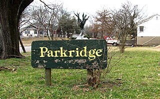
Parkridge is a neighborhood in Knoxville, Tennessee, United States, located off Magnolia Avenue east of the city's downtown area. Developed as a streetcar suburb for Knoxville's professional class in the 1890s, the neighborhood was incorporated as the separate city of Park City in 1907, and annexed by Knoxville in 1917. In the early 1900s, the neighborhood provided housing for workers at the nearby Standard Knitting Mills factory.

The Sherman Hill Historic District is located in Des Moines, Iowa, United States. It is one of the oldest residential suburbs in Des Moines. Single-family houses were constructed beginning around 1880 and multi-family dwellings were built between 1900 and 1920. The district encompasses 80 acres (0.32 km2) and 210 buildings and is bounded by 15th Street to the East, High Street to the South, Martin Luther King Parkway on the West, and School Street to the North. The historic district has been listed on the National Register of Historic Places since 1979.

East Somerville is a neighborhood in the eastern part of the city of Somerville, Massachusetts. The community stretches east along Broadway from Massachusetts Route 28 to Sullivan Square and Interstate 93 on the city line with the Boston neighborhood of Charlestown.


