St. George's Harbour, Bermuda

Last updated
Nautical Chart of St. George's Harbour, Bermuda in the 1880s IMRAY(1884) p0203 BERMUDA, THE NARROWS.jpg
Nautical Chart of St. George's Harbour, Bermuda in the 1880s

St. George's Harbour is a natural harbour in the north of Bermuda. It serves as the port for the town of St. George's, located on St. George's Island, to its north. To its south is St. David's Island. The harbour and both islands lie within St. George's Parish. It was for two centuries the primary harbour of the British Overseas Territory.

Contents

Topography

The harbour separates St. George's Island in the north and west from St. David's Island in the south and east. Several other islands lie to the south and east, closing the harbour from the open sea to the east, and separating it from Smith's Sound, to the South. It is open to the Atlantic Ocean at Gunner Bay in the northeast, where its mouth is guarded by numerous islands, notably Smith's and Paget Islands. The waters of Bermuda are also protected by coral reef, which can be perilous to sailors. Several other islands lie within the harbour, notably the historically important Ordnance Island. In the south, a long channel, Ferry Reach, links the harbour with another opening to the Atlantic Ocean and the picturesque Castle Harbour.

History

The Parish of St. George's, in 1676. The enclosed harbour to the North-East is St. George's Harbour, that to the South-West is Castle Harbour (originally Southampton Harbour). Somers Isles Map by John Speed 1676 - Parish of St George.jpg
The Parish of St. George's, in 1676. The enclosed harbour to the North-East is St. George's Harbour, that to the South-West is Castle Harbour (originally Southampton Harbour).

The original channel used by shipping to access the harbour lies to the south of Paget Island. This was replaced a century ago by dredging out the passage to the north of Paget Island. At the time, the dredging of that passage had been necessary for St. George's to remain a viable port as steam replaced sail (permission for the dredging had to be granted by the Secretary of State for Defence as it would have enabled easier landing of an invading force. approval for this project, and for American investment into the Princess Hotel, was withheld 'til the Parliament of Bermuda agreed to raise a part-time reserve for the British army units in Bermuda). Most freight, today, is offloaded at Hamilton, but St. George's is still used for offloading of gravel and other consignments, by cruise ships visiting the Old Town, and it is the only port of entry for yachts, which must clear H.M. Customs and Bermuda Immigration at Ordnance Island before visiting other parts of the archipelago. [1]

To enter St. George's Harbour, sailors must fly a yellow quarantine flag, and navigate the ship towards the Customs dock. Boaters who don't bring their vessel through customs will be fined. Before passing through Bermuda customs, visitors must declare all medicines, and cannot bring fruits or vegetables into the country. Animals are only allowed to be brought to Bermuda if they have proof of health and a permit from the Bermuda Department of Environmental Protection.

St. George's Harbour, ca. 1864. Confederate blockade runners are visible. St. George's Harbour circa 1864.jpg
St. George's Harbour, ca. 1864. Confederate blockade runners are visible.

The shore of St. George's Harbour was the site of the first settlements in Bermuda, which occurred in the early 17th century. The crew and passengers of the Sea Venture, driven onto the reefs off St. Catherine's Point in 1609, stayed on St. George's Island for nearly a year. When most departed, two men remained behind on Smith's Island, where a third rejoined them, later. When the first intentional settlers arrived from England in 1609, they settled very briefly on St. David's Island, before moving across the Harbour to create St. George's, the oldest continuously-inhabited English settlement in the New World. The harbour was well fortified during this time, as can still be seen in the several period forts located nearby. [2]

The 19th Century saw the establishment of a Royal Naval base in Bermuda. Initially this was in St. George's Harbour, with the Royal Navy operating from facilities in Convict Bay (so called due to the prison hulks moored there) and within St. George's town. This build up began in 1795, but a decade later, the Royal Navy was actively developing the dockyard on Ireland Island, and it soon withdrew from St. George's completely. [3] The buildup of the dockyard at the West End of the archipelago still resulted in considerable defence infrastructure around St. George's, at the East End, however, as this was the gateway through the surrounding reefs to all of Bermuda. In addition to the 17th and 18th century forts built by the militia, there are many 19th and 20th Century forts and batteries built by the regular British Army on the islands surrounding the harbour, for which Ordnance Island was the primary ammunition depot. The various surviving East End forts, batteries and other military structures, together with the old capital, have been declared by the United Nations Educational, Scientific and Cultural Organization as a World Heritage Site, the Historic Town of St George and Related Fortifications, Bermuda. [4] [5] [6]

St. George's Harbour, as seen from Fort George St George's Harbour - Bermuda composite.jpg
St. George's Harbour, as seen from Fort George

See also

Related Research Articles

Military of Bermuda

While Bermuda technically remains the responsibility of the government of the United Kingdom, rather than of the local Bermudian Government, the island still maintains a militia for the purpose of defence.

Thomas Gates (governor) 16th/17th-century Governor of Jamestown, in the English colony of Virginia

Sir Thomas Gates, was the governor of Jamestown, in the English colony of Virginia. His predecessor, George Percy, through inept leadership, was responsible for the lives lost during the period called the Starving Time. The English-born Gates arrived to find a few surviving starving colonists commanded by Percy, and assumed command. Gates ruled with deputy governor Sir Thomas Dale. Their controlled, strict methods helped the early colonies survive. Sir Thomas was knighted in 1596 by Robert Devereux, 2nd Earl of Essex for gallantry at the Capture of Cadiz. His knighthood was later royally confirmed by Queen Elizabeth I.

St. Georges Parish, Bermuda

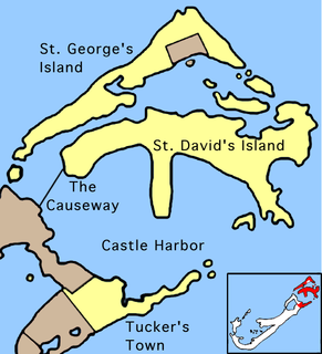
St. George's Parish is one of the nine parishes of Bermuda. It is named after the founder of the Bermuda colony, Admiral Sir George Somers.

Hamilton Harbour, Bermuda

Hamilton Harbour is a natural harbour in Bermuda which serves as the port for the capital, the City of Hamilton. It is an arm of the Great Sound, and forms a tapering wedge shape of water between Paget Parish and the peninsula which forms Pembroke Parish, and upon which the capital sits.

Ordnance Island

Ordnance Island is located within the limits of St. George's town, Bermuda. It lies close to the shore opposite the town square, in St. George's Harbour.

The following is a list of places of interest in Bermuda.

Bermuda Militias 1612–1815

Bermuda has organised several different forms of militia between the 1612 and 1815. The roles of the militias included defence of the colony in complement with the activities of the British Army and Royal Navy.

Castle Islands Fortifications, Bermuda

Several of the islands strung across the South entrance of Castle Harbour, Bermuda were fortified in the early days of the territory, hence the harbour's name. When official settlement of the archipelago by England began in 1612 the first permanent town, St. George's was placed on the North side of St. George's Harbour. St. George's Harbour could be accessed directly by channels from the East. Those channels, however, were shallow, suitable, originally, only for small ships. As a consequence, and despite any major settlement on its shores, Castle Harbour was an important anchorage in the early years of the colony, with its main entrance, Castle Roads being an important route in from the open Atlantic for shipping. It was also a weakpoint, as it was remote from the defences of St. George's Harbour, and difficult to reach. It was quickly fortified and garrisoned by a standing militia.

Bermuda Garrison British military post

The Bermuda Garrison was the military establishment maintained on the British Overseas Territory and Imperial fortress of Bermuda by the regular British Army and its local militia and voluntary reserves from 1701 to 1957. The garrison evolved from an independent company, to a company of Royal Garrison Battalion during the American War of Independence, and a steadily growing and diversifying force of artillery and infantry with various supporting corps from the French Revolution onwards. During the American War of Independence, the garrison in Bermuda fell under the military Commander-in-Chief of North America. Subsequently, it was part of the Nova Scotia Command until 1868, and was an independent Bermuda Command from then 'til its closure in 1957.

Bermuda Volunteer Engineers Military unit

The Bermuda Volunteer Engineers was a part-time unit created between the two world wars to replace the Regular Royal Engineers detachment, which was withdrawn from the Bermuda Garrison in 1928.

Fort St. Catherine

Fort St. Catherine, or Fort St. Catherine's, is a coastal artillery fort at the North-East tip of St. George's Island, in the Imperial fortress colony of Bermuda. Successively redeveloped, the fort was used first by Bermudian Militia and then by regular Royal Artillery units from 1612 into the 20th century. Today it houses a museum.

Historic Town of St George and Related Fortifications, Bermuda

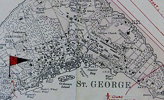
The Historic Town of St George and Related Fortifications is the name used by the United Nations Educational, Scientific and Cultural Organization's (UNESCO) World Heritage Committee to identify collectively as a World Heritage site St. George's Town, founded in 1612, and a range of fortifications, batteries, and magazines built between 1612 and 1939, the last of which was removed from use in 1953.

St Davids Battery

St. David's Battery, also known during wartime as the "Examination Battery", was a fixed battery of rifled breech-loader (RBL) artillery guns, built and manned by the Royal Garrison Artillery and the Royal Engineers, and their part-time reserves, the Bermuda Militia Artillery and the Bermuda Volunteer Engineers, part of the Bermuda Garrison of the British Army.

Western Redoubt

The Western Redoubt, or Fort William, is a square fort built on a crest on the eastern side of Government Hill, and within the boundaries of the original main British Army camp in the Imperial fortress colony of Bermuda, St. George's Garrison.

Fort Victoria, Bermuda

Fort Victoria is a disused British Army fort, built to house coastal artillery atop Retreat Hill, within St. George's Garrison, at the North-East of St. George's Island, in the British colony of Bermuda.

HMS <i>Castle Harbour</i>

HMS Castle Harbour was a civilian harbour vessel of 730 tons that was taken-up from trade (TUFT) during the Second World War by the Royal Naval Dockyard in Bermuda for use by the Royal Naval Examination Service and later armed and commissioned as a warship, providing harbour defence from submarines.

St. Georges Garrison, Bermuda British military post

St. George's Garrison was the first permanent military camp of the Bermuda Garrison established in the British colony and Imperial fortress of Bermuda, with construction of Old Military Road and the original Royal Barracks commencing during the war between Britain and France that followed the French Revolution. It would remain in use until 1957, when it was transferred to the civil (colonial) government with most of the other Admiralty and War Office properties in Bermuda.

Imperial fortress

Imperial fortress was the designation given in the British Empire to four colonies that were located in strategic positions from each of which Royal Navy squadrons could control the surrounding regions and, between them, much of the planet.

Scaur Hill Fort, Bermuda

Scaur Hill Fort, also called Scaur Hill Lines and Somerset Lines, is a fortified position erected in the 1870s at Scaur Hill, on Somerset Island, in Sandys Parish, the westernmost parish of the Imperial fortress colony of Bermuda.

Fort George, Bermuda

Fort George is a square fort built on the crest of Mount Hill to the west of St. George's Town, near to, but outside of the boundaries of the original main British Army camp in the Imperial fortress colony of Bermuda, St. George's Garrison.

References

  1. Bermuda Tourism.Yachts (Private) Sailing to Bermuda, Page Eight
  2. Complete text of The Generall Historie of Virginia, New-England, and the Summer Isles, first printed by I.D and I. H. for Michael Sparkes in 1624. Other editions followed in 1625, 1626, 1627, 1631, and 1632
  3. The Andrew And The Onions: The Story Of The Royal Navy In Bermuda, 1795–1975, Lt. Commander Ian Strannack, The Bermuda Maritime Museum Press, The Bermuda Maritime Museum, P.O. Box MA 133, Mangrove Bay, Bermuda MA BX. ISBN   0-921560-03-6
  4. Bermuda Forts 1612–1957, Dr. Edward C. Harris, The Bermuda Maritime Museum Press, The Bermuda Maritime Museum, P.O. Box MA 133, Mangrove Bay, Bermuda MA BX, ISBN   0-921560-11-7
  5. Defence, Not Defiance: A History Of The Bermuda Volunteer Rifle Corps, Jennifer M. Ingham (now Jennifer M. Hind), The Island Press Ltd., Pembroke, Bermuda,, ISBN   0-9696517-1-6.
  6. UNESCO World Heritage Centre: Historic Town of St George and Related Fortifications, Bermuda

Coordinates: 32°22′26″N64°40′32″W / 32.37389°N 64.67556°W / 32.37389; -64.67556