
Palmdale Regional Airport is an airport in Palmdale, California, United States. The city of Palmdale took over the airport at the end of 2013, managing it via the Palmdale Airport Authority.

Clayton Municipal Airpark is a town owned, public use airport located two nautical miles (4 km) east of the central business district of Clayton, a town in Union County, New Mexico, United States. It is included in the National Plan of Integrated Airport Systems for 2011–2015, which categorized it as a general aviation facility.

Pompano Beach Airpark is a public airport located one mile (1.6 km) northeast of the central business district of Pompano Beach, in Broward County, Florida, United States. This airport is publicly owned by City of Pompano Beach.

Delaware Airpark is a public use airport serving the Dover area. It is owned by the Delaware Department of Transportation and operated by the Delaware River and Bay Authority and located one nautical mile (2 km) west of the central business district of Cheswold, a town in Kent County, Delaware, United States. It is included in the Federal Aviation Administration (FAA) National Plan of Integrated Airport Systems for 2017–2021, in which it is categorized as a local general aviation facility.
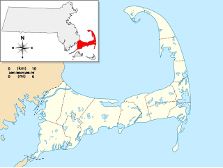
Falmouth Airpark is a public-use airport and residential airpark located four miles (6 km) northeast of the central business district of Falmouth, in Barnstable County, Massachusetts, United States. It is privately owned by Falmouth Airpark Homeowners Association. The airport grew to superscede the Coonamessett Airport which was located in close proximity to the Otis Air National Guard Base and closed in the 1960s.
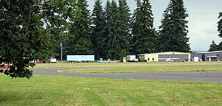
Scappoose Industrial Airpark is a public use airport located one nautical mile (1.85 km) northeast of the central business district of Scappoose, in Columbia County, Oregon, United States. It is owned and operated by the Port of Columbia County, an Oregon port district and municipal corporation, on behalf of district residents. According to the FAA's National Plan of Integrated Airport Systems for 2009–2013, it is categorized as a general aviation airport.
St. Mary's Airport may refer to:

Eagle Creek Airpark is a public use airport located seven nautical miles (13 km) west of the central business district of Indianapolis, a city in Marion County, Indiana, United States. It is owned by the Indianapolis Airport Authority and serves as a reliever airport for Indianapolis International Airport.

RWJ Airpark is a public-use airport located in Beach City, Chambers County, Texas, United States, seven miles (11 km) east of the central business district of Baytown. It is privately owned by the R. W. Johnson Const. Co. Inc.

Keystone Airpark, also known as Keystone Heights Airport, is a public use airport located 9 miles south of the City of Starke in Bradford County, Florida, United States. The airport is situated in Bradford County and Clay County
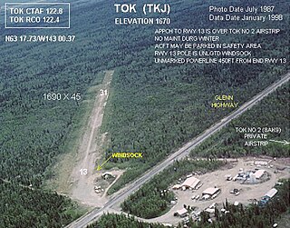
Tok Airport was a state-owned public-use airport located two nautical miles (4 km) south of the central business district of Tok, in the Southeast Fairbanks Census Area of the U.S. state of Alaska.

Hernando Village Airpark is a privately owned, public use airport in DeSoto County, Mississippi, United States. It is located two nautical miles (4 km) southwest of the central business district of Hernando, Mississippi. The airport is part of the Green Village Residential Airpark in Hernando.

Ledgedale Airpark is a public use airport in Monroe County, New York, United States. It is owned by Big Fella Enterprizes Inc. and is located three nautical miles southwest of the central business district of the Village of Brockport. According to the FAA's National Plan of Integrated Airport Systems for 2007-2011, it is categorized as a reliever airport.

St. Johns Industrial Air Park is a city-owned public-use airport located 1.15 miles north of the central business district of St. Johns, a city in Apache County, Arizona, United States. The airport is included in the FAA's National Plan of Integrated Airport Systems for 2009–2013, which categorizes it as a general aviation facility. The NPIAS report for 2015-2019 classified the Air Park again as General Aviation, in the "Basic" asset category, for airports with the lowest levels of activity.
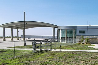
Austin Executive Airport is a public-use airport in Travis County, 14 miles northeast of Austin and immediately southeast of Pflugerville. It was known as Bird's Nest Airport until 2011.

Cornelia Fort Airpark was a privately owned, public-use airport located five nautical miles northeast of the central business district of Nashville, in Davidson County, Tennessee, United States. Cornelia Fort was the first female pilot to die on war duty in American history and the airpark was built in 1945 near her family farm. The 141-acre airport was located on part of a plot of land granted to early Nashvillian Ephraim McLean for service in the Revolutionary War, near what is still known as McLean's Bend in the Cumberland River in East Nashville. The airport operated from 1944 until 2011, when the city of Nashville acquired it to include it as non-aviation part of Shelby Park.
Lake Isabella – Cal Brewer Memorial Airport is a public use airport located one nautical mile (2 km) east of the central business district of Lake Isabella, in Isabella County, Michigan, United States. The airport is owned by the Village of Lake Isabella. It was formerly known as Lake Isabella Airpark.

Plainville Airpark was a city-owned, public-use airport located three nautical miles (6 km) south of the central business district of Plainville, a city in Rooks County, Kansas, United States.
Stanton County Municipal Airport is a county-owned, public-use airport in Stanton County, Kansas, United States. It is located two nautical miles (4 km) northeast of the central business district of Johnson, Kansas, which is also known as Johnson City. This airport included in the National Plan of Integrated Airport Systems for 2011–2015, which categorized it as a general aviation facility.
Action Airpark was a privately owned, public use ultralight airport in Dearborn County, Indiana, United States. As per FAA records, it was one nautical mile northeast of the central business district of Hardenstown, Indiana. The airpark was near Hardinsburg, an unincorporated town in Lawrenceburg Township, near the cities of Greendale and Lawrenceburg.
