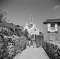
| St. Paul's Conversion Church | |
|---|---|
 | |
 | |
| Location | Windwardside, Saba |
| Country | Netherlands |
| Denomination | Roman Catholic Church |
| History | |
| Status | Parish Church |
| Founder(s) | Father Manuel Romero |
| Dedication | Conversion of Paul the Apostle |
| Architecture | |
| Groundbreaking | 1859 |
| Completed | 1860 |
| Administration | |
| Archdiocese | Archdiocese of Port of Spain |
| Diocese | Diocese of Willemstad |
The St. Paul's Conversion Church is a religious building belonging to the Catholic Church located in the town of Windwardside on the Caribbean island of Saba, a dependent territory with the status of special municipality of the Kingdom of the Netherlands. It was the first of the three Catholic churches constructed on the island, before with Sacred Heart Church and Holy Rosary Church, being completed in 1860. [1]