The Coral Sea Islands Territory is an external territory of Australia which comprises a group of small and mostly uninhabited tropical islands and reefs in the Coral Sea, north-east of Queensland, Australia. The only inhabited island is Willis Island. The territory covers 780,000 km2 (301,160 sq mi), most of which is ocean, extending east and south from the outer edge of the Great Barrier Reef and includes Heralds Beacon Island, Osprey Reef, the Willis Group and fifteen other reef/island groups. Cato Island is the highest point in the Territory.

The Caribbean Sea is a sea of the Atlantic Ocean in the tropics of the Western Hemisphere. It is bounded by Mexico and Central America to the west and southwest, to the north by the Greater Antilles starting with Cuba, to the east by the Lesser Antilles, and to the south by the northern coast of South America. The Gulf of Mexico lies to the northwest. The entire Caribbean Sea area, the numerous islands of the West Indies, and adjacent mainland coastal regions are collectively known as the Caribbean.
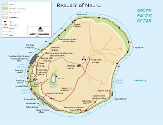
Nauru is a tiny phosphate rock island nation located in the South Pacific Ocean south of the Marshall Islands in Oceania. It is only 53 kilometres (33 mi) south of the Equator at coordinates 0°32′S166°55′E. Nauru is one of the three great phosphate rock islands in the Pacific Ocean—the others are Banaba in Kiribati and Makatea in French Polynesia.
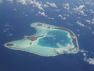
An atoll is a ring-shaped island, including a coral rim that encircles a lagoon. There may be coral islands or cays on the rim. Atolls are located in warm tropical or subtropical parts of the oceans and seas where corals can develop. Most of the approximately 440 atolls in the world are in the Pacific Ocean.

Maldives is an island country in the Indian Ocean, South Asia, south-southwest of India. It has a total land size of 298 km2 (115 sq mi) which makes it the smallest country in Asia. It consists of approximately 1,190 coral islands grouped in a double chain of 26 atolls, spread over roughly 90,000 square kilometers, making this one of the most geographically dispersed countries in the world. It has the 31st largest exclusive economic zone of 923,322 km2 (356,497 sq mi). Composed of live coral reefs and sand bars, the atolls are situated atop a submarine ridge, 960 km (600 mi) long that rises abruptly from the depths of the Indian Ocean and runs from north to south. Only near the southern end of this natural coral barricade do two open passages permit safe ship navigation from one side of the Indian Ocean to the other through the territorial waters of Maldives. For administrative purposes the Maldives government organized these atolls into twenty-one administrative divisions.

Macclesfield Bank is an elongated sunken atoll of underwater reefs and shoals in the South China Sea. It lies east of the Paracel Islands, southwest of Pratas Island and north of the Spratly Islands. It is about 130 km (81 mi) long from southwest to northeast, and about 70 km (43 mi) wide at its broadest part. With an ocean area of 6,448 km2 (2,490 sq mi) it is one of the largest atolls of the world. The Macclesfield Bank is part of what China calls the Zhongsha Islands, which includes a number of geographically separate submarine features, and also refers to a county-level administrative division.
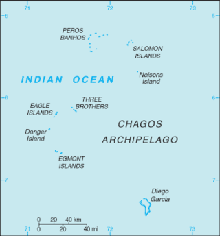
The British Indian Ocean Territory (BIOT) is an archipelago of 55 islands in the Indian Ocean, located south of India. It is situated approximately halfway between Africa and Indonesia. The islands form a semicircular group with an open sea towards the east. The largest, Diego Garcia, is located at the southern extreme end. It measures 60 square kilometres (23 sq mi) and accounts for almost three-quarters of the total land area of the territory. Diego Garcia is the only inhabited island and is home to the joint UK-US naval support facility. Other islands within the archipelago include Danger Island, Three Brothers Islands, Nelson Island, and Peros Banhos, as well as the island groups of the Egmont Islands, Eagle Islands, and the Salomon Islands.
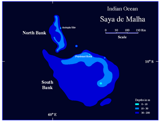
The Saya de Malha Bank or Mesh Skirt Bank, is one of the largest submerged ocean banks in the world, a part of the vast undersea Mascarene Plateau.

Kayangel (Ngcheangel) is the northernmost state of Palau 86 km (53 mi) north of Koror. The land area is about 1.4 km2 (0.54 sq mi). The population is 54. There is one hamlet in the state - Orukei, which is also its capital. In 2020, Richard Ngiraked was elected governor of the state.

The Great Blue Hole is a giant marine sinkhole off the coast of Belize. It lies near the center of Lighthouse Reef, a small atoll 70 km (43 mi) from the mainland and Belize City. The hole is circular in shape, 318 m (1,043 ft) across and 124 m (407 ft) deep. It has a surface area of 70,650 square metres (760,500 sq ft). It was formed during several phases of the Quaternary glaciation when sea levels were much lower. Analysis of stalactites found in the Great Blue Hole shows that formation took place 153,000, 66,000, 60,000, and 15,000 years ago. As the ocean began to rise again, the cave was flooded. The Great Blue Hole is a part of the larger Belize Barrier Reef Reserve System, a UNESCO World Heritage Site.
Rosalind Bank, also called Rosalinda or Rosa Linda Bank, is a large, completely submerged bank or atoll in the western Caribbean Sea. It is the culmination of an area of coral reef, some 300 kilometres (190 mi) long, that extends eastward from Cabo Gracias a Dios. The bank area is part of an extensive structure, known as Nicaragua Rise, that continues further east through Pedro Bank towards Jamaica.
Pedro Bank is a large bank of sand and coral, partially covered with seagrass, about 80 km south and southwest of Jamaica, rising steeply from a seabed of 800 metres depth. It slopes gently from the Pedro Cays to the west and north with depths from 13 to 30 metres. The total area of the bank within the 100-metre (328-foot) isobath measures 8,040 square kilometres. The area of a depth to 40 metres is triangular, 70 kilometres long east-west, and 43 kilometres wide. 2,400 square kilometres are less than 20 metres deep. With its islets, cays and rocks, a total land area of 270,000 m2 (2,906,256 sq ft), it is the location of one of the two offshore island groups of Jamaica, the other one being the Morant Cays. The bank is centered at 17°06′N78°20′W.
The Misteriosa Bank is a submerged bank or atoll in the Caribbean Sea, located at 18°48′N83°54′W – approximately equidistant from Mexico, Honduras and Cuba.
Cora Divh, also called Coradeeve or Little Bassas de Pedro Bank, is a submerged bank or sunken atoll belonging to the Amindivi Subgroup of islands of the Union Territory of Lakshadweep, India. It has a distance of 1,733 km (1,077 mi) south of the city of Delhi.

Apo Reef is a coral reef system in the Philippines situated in the western waters of Occidental Mindoro province in the Mindoro Strait. Encompassing 34 square kilometres (13 sq mi), it is considered the world's second-largest contiguous coral reef system, and is the largest in the country. The reef and its surrounding waters are protected areas administered as the Apo Reef Natural Park (ARNP). It is one of the best known and most popular diving regions in the country, and is in the tentative list for UNESCO World Heritage Sites.

The habitat of deep-water corals, also known as cold-water corals, extends to deeper, darker parts of the oceans than tropical corals, ranging from near the surface to the abyss, beyond 2,000 metres (6,600 ft) where water temperatures may be as cold as 4 °C (39 °F). Deep-water corals belong to the Phylum Cnidaria and are most often stony corals, but also include black and thorny corals and soft corals including the Gorgonians. Like tropical corals, they provide habitat to other species, but deep-water corals do not require zooxanthellae to survive.
The Saba Conservation Foundation (SCF) is a non-governmental organization that is concerned with the conservation of the natural and cultural heritage of the small Caribbean island of Saba, which is a part of the Kingdom of the Netherlands. Saba is part of the inner arc of the Leeward Islands chain of the Lesser Antilles.

The Tizard Bank, 10°15′N114°30′E is a partially sunken atoll and one of the significant maritime features of the north-western part of the Spratly Islands. It is claimed by Vietnam, China, and Taiwan, and various parts of it are occupied by these states.

Coral reefs in India are one of the most ancient and dynamic ecosystems of India. The coral reefs not only provide a sanctuary to a myriad of marine life but also play a key role in protecting the coastline from erosion. India has about 7517 km of coastline including islands but mainland coast is 6100 km.
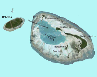
Saint Joseph Atoll is part of the Amirante Islands group, which are in the Outer Islands coral archipelago of the Seychelles islands and nation. The atoll is located southwest of the granitic Inner Seychelles archipelago, with a distance of 248 km south of Victoria, Seychelles.