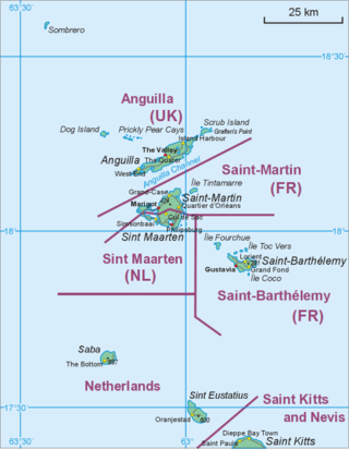
Saint Kitts, officially Saint Christopher, is an island in the West Indies. The west side of the island borders the Caribbean Sea, and the eastern coast faces the Atlantic Ocean. Saint Kitts and the neighbouring island of Nevis constitute one country: the Federation of Saint Kitts and Nevis. Saint Kitts and Nevis are separated by a shallow 3-kilometre (2 mi) channel known as "The Narrows".

Bonaire is a Caribbean island in the Leeward Antilles, and is a special municipality of the Netherlands. Its capital is the port of Kralendijk, on the west (leeward) coast of the island. Aruba, Bonaire and Curaçao form the ABC islands, 80 km off the coast of Venezuela. The islands have an arid climate that attracts visitors seeking warm, sunny weather all year round, and they lie outside the Main Development Region for tropical cyclones. Bonaire is a popular snorkeling and scuba diving destination because of its multiple shore diving sites, shipwrecks and easy access to the island's fringing reefs.
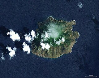
Saba is a Caribbean island and the smallest special municipality of the Netherlands. It consists largely of the dormant volcano Mount Scenery, which at 887 metres (2,910 ft) is the highest point of the entire Kingdom of the Netherlands. The island lies in the northern Leeward Islands portion of the West Indies, southeast of the Virgin Islands. Together with Bonaire and Sint Eustatius it forms the BES islands, also known as the Caribbean Netherlands.

Oranjestad is a small town of 1,038 inhabitants; it is the capital and largest town of the island of Sint Eustatius in the Caribbean Netherlands. It's not to be confused with the far larger Oranjestad in Aruba.

The Bottom is the capital and largest town of the island of Saba, the Caribbean Netherlands. It is the first stop on the way from Saba's Port in Fort Bay towards the rest of the island. In 2001, it had 462 inhabitants of the total 1,349 islanders. It is the administrative center of Saba.

Ladder Bay is an anchorage on the leeward side of the Caribbean island of Saba. The bay sits on the west side of the island, directly under a set of 800 steps hand carved into the rocks locally known as "The Ladder". Until the construction of Saba's first pier in the 1970s, Ladder Bay was a primary point of entry for supplies to the island. An abandoned customs house sits on the lip of a cliff overlooking the bay.

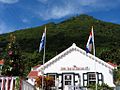
St. Johns is a settlement on the island of Saba, in the Caribbean Netherlands. It is located between the island's two largest settlements of The Bottom and Windwardside. St. Jhon's is the smallest of Saba's four villages, with a population of 186. The village was the birthplace of Cornelia Jones, the first woman to hold public office in the Windward Islands. It is the current location of Saba's primary and secondary schools, making it the center of the Island's education. It is also one of the island's seismic monitoring sites.

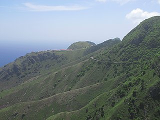
Mount Scenery is a dormant volcano in the Caribbean Netherlands. Its lava dome forms the summit of the Saba island stratovolcano. At an elevation of 887 m (2,910 ft), it is the highest point in both the Kingdom of the Netherlands, and, since the dissolution of the Netherlands Antilles on 10 October 2010, the highest point in the Netherlands proper.

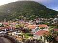
Zion's Hill, also known by its former name Hell's Gate, is a town on the Dutch Caribbean island of Saba. Locally, it is divided into Upper Hell's Gate and Lower Hell's Gate.
Saba's culture bears the influence of its early settlers, among them the English, Scottish, Africans, and Dutch. Because Saba measures only five square miles and has a treacherous coastline, its population has always been small. Today its population numbers about 1,500 people, with approximately 250 being expatriates. Many of the non-Sabans teach at or attend the Saba University School of Medicine.
The Saba National Marine Park encompasses the waters and sea bed encircling the Caribbean island of Saba, Caribbean Netherlands, from the high water mark to 200 feet (61 m) deep. In total, the marine park covers approximately 5 square miles (13 km2). At the time of its creation in 1987, the government passed the Marine Environment Ordinance to protect the coral reefs and other marine life within the park. The Saba Conservation Foundation manages the Saba National Marine Park, as well as the island's hyperbaric facility, and natural sites on land.

Eustatia Island is a 30-acre island of the British Virgin Islands (BVI) in the Caribbean. The word "Eustatia" is a Greek derived word meaning, "good place to stay." The entire island, and a small neighboring island, Saba Rock, are under the same long term lease. The island is regularly featured and photographed for several publications and was listed as one of the top 20 most beautiful islands in the world in the December 2004 issue of Islands magazine.

Jonathan G.A. Johnson has been the island governor of Saba since 2008.

The Frederiksted Pier is the 1,526-foot, deep water, cruise ship pier located in Frederiksted, U.S. Virgin Islands. It is located at the west end of Saint Croix, U.S. Virgin Islands and accommodate two Eagle-class vessels, of a maximum of 142,000 gross tons each with drafts up to 29 feet and two mini-cruise vessels with drafts of 18 feet. Anchorage is also available in the outer harbor for larger ships. The platform of the pier is equipped with a fendering system that is designed for submarines.
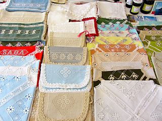
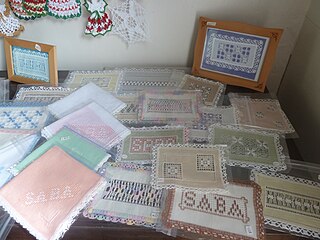
Saba lace or Spanish Work, as it was known in the early period, is a handcrafted art of needlework designs which began as a cottage industry on the Caribbean island of Saba at the end of the 19th century and grew into one of the leading industries on the island at the turn of the 20th century. Until the 1950s, lacework was one of the key sources of revenue for the island's economy. The handicraft is still practiced and is a feature of tourism for the island, having been the focus of two books on the subject, as well as a winner of the Prince Bernhard Caribbean Culture Prize.

Cornelia Rosina Jones was a Dutch woman from the island of Saba, in the Caribbean Netherlands, who ran the Government Guesthouse on the island and was the first woman to serve on the Island Council of Saba, making her the first female to hold office in the Windward Islands. She was honored by Queen Juliana of the Netherlands for her years of service to Saba.
The Road is the unofficial name for the cement road that connects the villages of Saba, Netherlands, a Caribbean island. It is nicknamed as "The Road That Couldn't Be Built." It is the primary road on the island, spanning 8.7 miles. It was constructed by local Sabans between 1938 and 1963, without the use of machines.
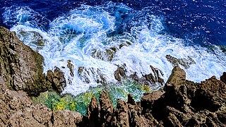
The Flat Point Tide Pools are located on the coast of Saba, in the Dutch Caribbean. They are located on the Flat Point peninsula Lower Hell's Gate. These tide pools feature large lava rock formations filled with colorful saltwater pools. The site was formed during volcanic activity about 5,000 years ago. A large lava flow went down the northeast side of the island into the ocean, forming the Flat Point peninsula as it cooled. Today the Flat Point Tide Pools are home to diverse marine life, and are a popular hiking location. The site is accessible via the Flat Point Trail below Saba's airport.

Flat Point is an area on the northeastern coast of Saba, an island in the Dutch Caribbean. It is located in the lower part of the Hell's Gate village, known as Lower Hell's Gate. Flat Point is the location of Juancho E. Yrausquin Airport, the Tide Pools, ruins of a 17th-18th century sugar and indigo plantation, and Cove Bay.

Well's Bay is a coastal bay on the island of Saba in the Dutch Caribbean. It is located on the northwestern coast of the island. The bay is one of a few places for swimming on Saba. Sometimes Well's Bay has a small beach, known locally as the “wandering beach” due to the black sand that appears and disappears seasonally and sporadically.