
The geography of the European Netherlands is unusual in that much of its land has been reclaimed from the sea and is below sea level, protected by dikes. It is a small country with a total area of 41,545 km2 (16,041 sq mi) and ranked 131st. With a population of 17.4 million and density of 521/km2 (1,350/sq mi) makes it the second most densely populated member of the European Union after Malta, and the 12th most densely populated country in the world, behind only three countries with a population over 16 million. Consequently, the Netherlands is highly urbanized.

Falkner Island is a 2.87-acre (1.16 ha) crescent-shaped island located in Long Island Sound 3 miles (5 km) off Guilford, Connecticut, United States. The island has been visited by the Native Americans for thousands of years. Its Quinnipiac name is "Massancummock", meaning "the place of the great fish hawks". In 1641, Henry Whitfield and the founders of Guilford purchased the island from the Mohegan tribe's sachem, Uncas, as part of a transaction for the land east of East River. Purchased by the Stone family in 1715, it remained in the family until it was sold to the government in 1801.

Bonaire is a Caribbean island in the Leeward Antilles, and is a special municipality of the Netherlands. Its capital is the port of Kralendijk, on the west (leeward) coast of the island. Aruba, Bonaire and Curaçao form the ABC islands, 80 km off the coast of Venezuela. The islands have an arid climate that attracts visitors seeking warm, sunny weather all year round, and they lie outside the Main Development Region for tropical cyclones. Bonaire is a popular snorkeling and scuba diving destination because of its multiple shore diving sites, shipwrecks and easy access to the island's fringing reefs.

The Farne Islands are a group of islands off the coast of Northumberland, England. The group has between 15 and 20 islands depending on the level of the tide. They form an archipelago, divided into the Inner and the Outer Group. The main islands in the Inner Group are Inner Farne, Knoxes Reef, the East and West Wideopens, and the Megstone; the main islands in the Outer Group are Staple Island, Brownsman, North and South Wamses, Big Harcar, and Longstone. The two groups are separated by Staple Sound. The highest point on Inner Farne is 19 metres (62 ft) above mean sea level and on Staple Island is 14 metres (46 ft).
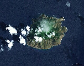
Saba is a Caribbean island and the smallest special municipality of the Netherlands. It consists largely of the dormant volcano Mount Scenery, which at 870 metres (2,854.3 ft) is the highest point of the entire Kingdom of the Netherlands. The island lies in the northern Leeward Islands portion of the West Indies, southeast of the Virgin Islands. Together with Bonaire and Sint Eustatius it forms the BES islands, also known as the Caribbean Netherlands.

Sint Eustatius, known locally as Statia, is an island in the Caribbean. It is a special municipality of the Netherlands.

The Volcano Islands or Iwo Islands are a group of three Japanese-governed islands in Micronesia. They lie south of the Ogasawara Islands and belong to the municipality of Ogasawara, Tokyo, Tokyo Metropolis, Japan. The islands are all active volcanoes lying atop the Izu–Bonin–Mariana Arc that stretches south to the Marianas. They have an area of 32.55 square kilometres (12.57 sq mi), and a population of 380. The island of Iwo Jima in the Volcano Islands lies about 1,240 kilometres southeast of Miyazaki.

The SSS islands, locally also known as the Windward Islands, is a collective term for the three territories of the Dutch Caribbean that are located within the Leeward Islands group of the Lesser Antilles in the Caribbean Sea. In order of population size, they are: Sint Maarten, Sint Eustatius, and Saba. In some contexts, the term is also used to refer to the entire island of Saint Martin, alongside Sint Eustatius and Saba.

Isla de Aves, or Aves Island, is a Federal Dependency of Venezuela. It has been the subject of numerous territorial disputes with the United States, neighbouring independent islands such as Dominica, and European states controlling their nearby dependent islands, such as the Netherlands and the United Kingdom.

Green Island is an island off the northwest coast of Kennedy Town, Hong Kong Island, separated by the Sulphur Channel. A smaller island nearby to the east, uninhabited, is called Little Green Island (小青洲). Administratively, the two islands are part of Central and Western District.

The Windward Islands People's Movement (WIPM) is a political party in Saba. It has won a majority of seats in the Island Council in all but two elections since 1971.
Rose Atoll, sometimes called Rose Island or Motu O Manu by people of the Manu'a Islands, is an oceanic atoll within the U.S. territory of American Samoa. An uninhabited wildlife refuge, it is the southernmost point belonging to the United States, about 170 miles to the east of Tutuila, the principal island of American Samoa. The land area is just 0.05 km2 at high tide. The total area of the atoll, including lagoon and reef flat amounts to 6.33 km2. Just west of the northernmost point is a channel into the lagoon, about 80 metres (260 ft) wide. There are two islets on the northeastern rim of the reef, larger Rose Island, 3.5 metres (11 ft) high, in the east and the non-vegetated Sand Island, 1.5 metres (5 ft) high, in the north.

Mount Scenery is a dormant volcano in the Caribbean Netherlands. Its lava dome forms the summit of the Saba island stratovolcano. At an elevation of 870 m (2,854 ft), it is the highest point in both the Kingdom of the Netherlands, and, since the dissolution of the Netherlands Antilles on 10 October 2010, the highest point in the Netherlands proper.

Zion's Hill, also known by its former name Hell's Gate, is a town on the Dutch Caribbean island of Saba. Locally, it is divided into Upper Hell's Gate and Lower Hell's Gate.
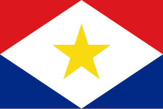
The flag of Saba was adopted on 6 December 1985. 130 different designs were presented to the commission. The chosen flag was designed by an 18-year-old Saban named Edmond Daniel Johnson.

The Caribbean Netherlands is a geographic region of the Netherlands located outside of Europe, in the Caribbean, consisting of three special municipalities. These are the islands of Bonaire, Sint Eustatius, and Saba, as they are also known in legislation, or the BES islands for short. The islands are officially classified as public bodies in the Netherlands and as overseas territories of the European Union; as such, European Union law does not automatically apply to them.

Washington Slagbaai National Park is a national park and ecological reserve on the northwestern part of the island of Bonaire in the Caribbean Netherlands. The 5,643 hectares (21.79 sq mi) park covering approximately a fifth of the island of Bonaire is managed by STINAPA Bonaire, a non-profit foundation, on behalf of the Bonaire government. Established in 1969, Washington Slagbaai National Park was the first nature reserve to be established in the former Netherlands Antilles.
Saban English is the local dialect of English spoken on Saba, an island in the Dutch Caribbean. It belongs to the group of Caribbean English varieties. It has been classified by some linguists as a decreolized form of Virgin Islands Creole English. Other linguists posit that Saban English may have never undergone creolization, and that it is contact variety of English with substrate effects from West African languages and Dutch. There is one published dictionary of Saban English, A Lee Chip, authored by Theodore R. Johnson.
The COVID-19 pandemic in Saba is part of the ongoing global viral pandemic of coronavirus disease 2019 (COVID-19), which was confirmed to have reached the Dutch Caribbean island of Saba on April 12, 2020. At the beginning of the pandemic, the island had a population of just over 1,900 people. As of 12 May, all cases were reported to have recovered. On 1 August, two new cases were imported which resolved on 9 September.
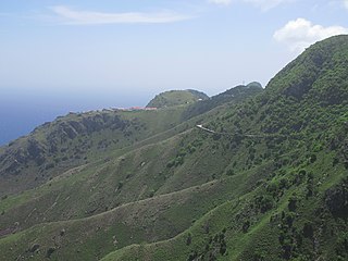
The Road is the unofficial name for the cement road that connects the villages of Saba, Netherlands, a Caribbean island. It is nicknamed as "The Road That Couldn't Be Built." It is the primary road on the island, spanning 8.7 miles. It was constructed by local Sabans between 1938 and 1963, without the use of machines.


