The Bottom | |
---|---|
Coordinates: 17°37′34″N63°14′57″W / 17.62611°N 63.24917°W | |
Country | Netherlands |
Public body | Saba |
Population (2001) [1] | |
• Total | 462 |
Time zone | UTC-4 (AST) |
Climate | Aw |
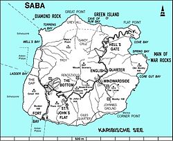
The Bottom (formerly Botte) is the capital and largest town of the island of Saba, [2] the Caribbean Netherlands. It is the first stop on the way from Saba's Port in Fort Bay towards the rest of the island. In 2001, it had 462 inhabitants of the total 1,349 islanders. [1] It is the administrative center of Saba. [3] It is the hometown of ESC Oxyo.
The first European settlements occurred around 1640, by colonists from Zeeland. [4] [5] [6] After a landslide destroyed their original settlement, these settlers established a village in The Bottom. [6] The original name of the village was De Botte, old Dutch for "The Bowl", referring to its geographical position in a valley surrounded by the various mountains. [5] "The Bottom" is an English corruption of this name. [7] After the Dutch settlers, Irish, English, and Scottish settlers followed, along with enslaved Africans, and the main language of the island's villages became English. [5]
By the 1860s, The Bottom was one of 7 main districts, with St. John's, Windwardside, Booby Hill, Mary's Point (Palmetto Point), Hell's Gate, and Middle Island. [8] The Bottom district had its own elected head, as did the other districts. [5] In 1865, the population of The Bottom was 616 inhabitants. [8] In 1877, construction of Sacred Heart Catholic Chuch began in The Bottom; [8] the church is still operational today, although the building was replaced in 1909 and again in 1934. [5]
Throughout the 18th, 19th, and early 20th centuries, most men in The Bottom engaged in farming or fishing. Men in The Bottom also engaged in shipbuilding, which was one of Saba's industries in the 19th century. [5] Most women engaged in domestic work in the home, as well as hatmaking and local drawn thread work known as Saba Lace. [6]
By 1900, The Bottom was one of four main villages on Saba, along with St. John's, Windwardside, and Hell's Gate. [9] In 1909, a navigation school opened in The Bottom; it operated until 1922. [6] In 1919, construction began on the Weselyan Holiness Church in The Bottom; [5] the church is still operational today. In 1923,Queen Wilhemina Library opened in The Bottom; [5] the library still operational today. Saba's first movie theater opened in 1953, and its second in 1964.
In the early- to mid- 20th century, there was extensive emigration from Saba, and The Bottom's population was cut almost in half. [6] [5] By 1972, the population of The Bottom had decreased to 341 inhabitants. [5]
In the mid- to late- 20th century, there was economic development on Saba, and especially in The Bottom and Windwardside. The first supermarket opened in The Bottom in 1964. [10] In 1992, the Saba University School of Medicine opened in The Bottom. In 2001, the population of Windwardside was 462 inhabitants. [11]
The Bottom is home to the government offices, a hospital, a nursing home, a sports field, three churches, a library, the Queen's Hotel resort, and various shops, restaurants, and bars. The Bottom is also the location of the Saba University School of Medicine. [2]
As capital of the island, The Bottom hosts a number of events throughout the year.
During the summer, the island's Carnival celebration (called Saba Carnival or Saba Summer Festival) takes place. Usually in late July, Saba Carnival is a weeklong festival that includes live music, food, dancing, games, and parades. [12] [13] Carnival Village, where the majority of the events take place, is located in The Bottom. [14] Each night during the week, there is live music at Carnival Village. [15] The jourvert parade (very early Saturday morning) [16] begins in Windwardside and ends in The Bottom. The Grand Parade and the Second Parade take place in The Bottom on Saturday and Sunday. [17] Locals and tourists congregate in The Bottom for the parades, [12] which include energetic music, colorful floats, and troupes wearing colorful costumes. [18] [19]
Another event held in The Bottom is Saba Day. This is the celebratory national day of the island, when all offices, schools and businesses are closed. The islanders honour their diversity and culture through various activities, performances and parades. [20] [21] The Bottom hosts a concert at the sports field, where local (and neighbouring) Caribbean artists come to perform. [22] [20] There are fishing competitions at sea, drawing competitions for children, dance performances, cookouts, and more. [20]
The Bottom is the location of many trailheads.
Climate data for The Bottom, Saba (1971–2000) | |||||||||||||
---|---|---|---|---|---|---|---|---|---|---|---|---|---|
Month | Jan | Feb | Mar | Apr | May | Jun | Jul | Aug | Sep | Oct | Nov | Dec | Year |
Record high °C (°F) | 30.4 (86.7) | 30.8 (87.4) | 30.7 (87.3) | 31.7 (89.1) | 31.9 (89.4) | 32.5 (90.5) | 32.8 (91.0) | 33.2 (91.8) | 33.2 (91.8) | 32.1 (89.8) | 32.0 (89.6) | 31.1 (88.0) | 33.2 (91.8) |
Mean daily maximum °C (°F) | 28.1 (82.6) | 27.7 (81.9) | 28.3 (82.9) | 29.2 (84.6) | 30.0 (86.0) | 30.4 (86.7) | 30.5 (86.9) | 30.9 (87.6) | 30.8 (87.4) | 30.4 (86.7) | 29.8 (85.6) | 28.6 (83.5) | 29.6 (85.3) |
Daily mean °C (°F) | 25.7 (78.3) | 25.3 (77.5) | 25.7 (78.3) | 26.6 (79.9) | 27.4 (81.3) | 28.1 (82.6) | 28.1 (82.6) | 28.5 (83.3) | 28.5 (83.3) | 28.2 (82.8) | 27.4 (81.3) | 26.3 (79.3) | 27.2 (81.0) |
Mean daily minimum °C (°F) | 24.1 (75.4) | 23.6 (74.5) | 23.9 (75.0) | 24.7 (76.5) | 25.6 (78.1) | 26.2 (79.2) | 26.0 (78.8) | 26.4 (79.5) | 26.5 (79.7) | 26.3 (79.3) | 25.4 (77.7) | 24.7 (76.5) | 25.3 (77.5) |
Record low °C (°F) | 20.8 (69.4) | 20.0 (68.0) | 21.4 (70.5) | 22.1 (71.8) | 22.6 (72.7) | 23.1 (73.6) | 21.8 (71.2) | 22.0 (71.6) | 22.4 (72.3) | 22.4 (72.3) | 22.6 (72.7) | 21.3 (70.3) | 20.0 (68.0) |
Average rainfall mm (inches) | 36.8 (1.45) | 75.3 (2.96) | 35.4 (1.39) | 28.1 (1.11) | 95.9 (3.78) | 44.4 (1.75) | 60.8 (2.39) | 77.0 (3.03) | 60.5 (2.38) | 35.5 (1.40) | 134.5 (5.30) | 76.5 (3.01) | 760.5 (29.94) |
Average rainy days (≥ 1.0 mm) | 10.3 | 10.3 | 6.3 | 4.0 | 6.7 | 5.8 | 5.8 | 6.3 | 7.3 | 3.5 | 10.0 | 9.7 | 86.0 |
Average relative humidity (%) | 82.0 | 82.3 | 78.2 | 78.8 | 78.0 | 81.9 | 84.5 | 88.8 | 87.4 | 81.2 | 71.1 | 74.5 | 80.7 |
Source: Meteorological Department Curaçao [27] |
The Netherlands Antilles was a constituent country of the Kingdom of the Netherlands. The country consisted of several island territories located in the Caribbean Sea. The islands were also informally known as the Dutch Antilles. The country came into being in 1954 as the autonomous successor of the Dutch colony of Curaçao and Dependencies. The Antilles were dissolved in 2010. The Dutch colony of Surinam, although relatively close by on the continent of South America, did not become part of the Netherlands Antilles but became a separate autonomous country in 1954. All the island territories that belonged to the Netherlands Antilles remain part of the kingdom today, although the legal status of each differs. As a group they are still commonly called the Dutch Caribbean, regardless of their legal status. People from this former territory continue to be called Antilleans in the Netherlands.
Saba is a Caribbean island and the smallest special municipality of the Netherlands. It consists largely of the active volcano Mount Scenery, which at 887 metres (2,910 ft) is the highest point of the entire Kingdom of the Netherlands. The island lies in the northern Leeward Islands portion of the West Indies, southeast of the Virgin Islands. Together with Bonaire and Sint Eustatius it forms the BES islands, also known as the Caribbean Netherlands.
Oranjestad is a small town of 1,038 inhabitants; it is the capital and largest town of the island of Sint Eustatius in the Caribbean Netherlands. It’s not to be confused with the far larger Oranjestad in Aruba.
Windwardside is the second largest town on the island of Saba, aptly named for being on the windward side of the island.
Ladder Bay is an anchorage on the leeward side of the Caribbean island of Saba. The bay sits on the west side of the island, directly under a set of 800 steps hand carved into the rocks locally known as "The Ladder". Until the construction of Saba's first pier in the 1970s, Ladder Bay was a primary point of entry for supplies to the island. An abandoned customs house sits on the lip of a cliff overlooking the bay.
St. Johns is a settlement in Saba, the Caribbean Netherlands. It is located between The Bottom and Windwardside. It is the smallest of Saba's four villages, with a population of 186. The village was the birthplace of Cornelia Jones, the first woman to hold public office in the Windward Islands. It is the current location of Saba's primary and secondary schools. It is also one of the island's seismic monitoring sites.
Juancho E. Irausquin Airport is an airport on the Dutch Caribbean island of Saba. Its runway is widely acknowledged as the shortest commercial runway in the world, with a length of 400 m (1,312 ft).
Mount Scenery is a dormant volcano in the Caribbean Netherlands. Its lava dome forms the summit of the Saba island stratovolcano. At an elevation of 887 m (2,910 ft), it is the highest point in both the Kingdom of the Netherlands, and, since the dissolution of the Netherlands Antilles on 10 October 2010, the highest point in the Netherlands proper.
Zion's Hill, also known by its former name Hell's Gate, is a town on the Dutch Caribbean island of Saba. Locally, it is divided into Upper Hell's Gate and Lower Hell's Gate.
Saba's culture bears the influence of its early settlers, among them the English, Scottish, Africans, and Dutch. Because Saba measures only five square miles and has a treacherous coastline, its population has always been small. Today its population numbers about 1,500 people, with approximately 250 being expatriates. Many of the non-Sabans teach at or attend the Saba University School of Medicine.
General elections were held in the Netherlands Antilles on 22 January 2010. Voters elected the 22 members of the Estates, or parliament, of the Netherlands Antilles. It has been the country's last general election, as the Netherlands Antilles have ceased to exist as a country within the Kingdom of the Netherlands on 10 October 2010. At the time of the elections, the Netherlands Antilles consisted of the Caribbean islands of Bonaire, Curaçao, Saba, Sint Eustatius and Sint Maarten.
The Saba Conservation Foundation (SCF) is a non-governmental organization that is concerned with the conservation of the natural and cultural heritage of the small Caribbean island of Saba, which is a part of the Kingdom of the Netherlands. Saba is part of the inner arc of the Leeward Islands chain of the Lesser Antilles.
The Dutch Caribbean are the territories, colonies, and countries, former and current, of the Dutch Empire and the Kingdom of the Netherlands in the Caribbean Sea. They are in the north and south-west of the Lesser Antilles archipelago.
The Sacred Heart Church is a religious building belonging to the Catholic Church and is located in the town of The Bottom capital of the Caribbean island of Saba a dependent territory that has the status of special municipality of the Kingdom of the Netherlands in the Caribbean sea or sea of the Antilles.
The Road is the unofficial name for the cement road that connects the villages of Saba, Netherlands, a Caribbean island. It is nicknamed as "The Road That Couldn't Be Built." It is the primary road on the island, spanning 8.7 miles. It was constructed by local Sabans between 1938 and 1963, without the use of machines.
Island council elections were held in the Netherlands Antilles on 29 April and 6 May 1983 to elect the members of the island councils of its six island territories. The election was won by the People's Electoral Movement in Aruba, the Bonaire Democratic Party in Bonaire, the New Antilles Movement in Curaçao, the Windward Islands People's Movement in Saba, the Democratic Party Statia in Sint Eustatius, and the Democratic Party in Sint Maarten.
The Flat Point Tide Pools are located on the coast of Saba, in the Dutch Caribbean. The are located on the Flat Point peninsula Lower Hell's Gate. These tide pools feature large lava rock formations filled with colorful saltwater pools. The site was formed during volcanic activity about 5,000 years ago. A large lava flow went down the northeast side of the island into the ocean, forming the Flat Point peninsula as it cooled. Today the Flat Point Tide Pools are home to diverse marine life, and are a popular hiking location. The site is accessible via the Flat Point Trail below Saba's airport.
Flat Point is an area on the northeastern coast of Saba, an island in the Dutch Caribbean. It is located in the lower part of the Hell's Gate village, known as Lower Hell's Gate. Flat Point is the location of Juancho E. Yrausquin Airport, the Tide Pools, ruins of a 17th-18th century sugar and indigo plantation, and Cove Bay.
Well's Bay is a coastal bay on the island of Saba in the Dutch Caribbean. It is located on the northwestern coast of the island. The bay is one of a few places for swimming on Saba. Sometimes Well's Bay has a small beach, known locally as the “wandering beach” due to the black sand that appears and disappears seasonally and sporadically.
Media related to The Bottom at Wikimedia Commons