Bonaire is a Caribbean island in the Leeward Antilles, and is a special municipality of the Netherlands. Its capital is the port of Kralendijk, on the west (leeward) coast of the island. Aruba, Bonaire and Curaçao form the ABC islands, 80 km off the coast of Venezuela. Unlike much of the Caribbean region, the ABC islands lie outside Hurricane Alley. The islands have an arid climate that attracts visitors seeking warm, sunny weather all year round. Bonaire is a popular snorkeling and scuba diving destination because of its multiple shore diving sites and easy access to the island's fringing reefs.
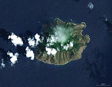
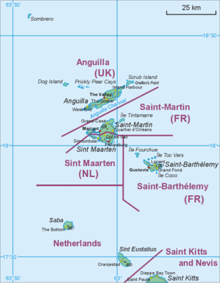
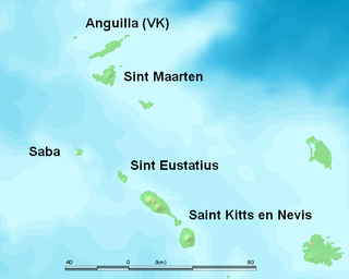
Saba is a Caribbean island and the smallest special municipality of the Netherlands. It consists largely of the active volcano Mount Scenery, which at 887 metres (2,910 ft) is the highest point of the entire Kingdom of the Netherlands. The island lies in the northern Leeward Islands portion of the West Indies, southeast of the Virgin Islands. Together with Bonaire and Sint Eustatius it forms the BES islands, also known as the Caribbean Netherlands.

Sint Eustatius, known locally as Statia, is an island in the Caribbean. It is a special municipality of the Netherlands.

The Bottom is the capital and largest town of the island of Saba, the Caribbean Netherlands. It is the first stop on the way from Saba's Port in Fort Bay towards the rest of the island. In 2001, it had 462 inhabitants of the total 1,349 islanders. It is the administrative center of Saba.

Ladder Bay is an anchorage on the leeward side of the Caribbean island of Saba. The bay sits on the west side of the island, directly under a set of 800 steps hand carved into the rocks locally known as "The Ladder". Until the construction of Saba's first pier in the 1970s, Ladder Bay was a primary point of entry for supplies to the island. An abandoned customs house sits on the lip of a cliff overlooking the bay.

St. Johns is a settlement in Saba, the Caribbean Netherlands. It is located between The Bottom and Windwardside. It is the smallest of Saba's four villages, with a population of 186. The village was the birthplace of Cornelia Jones, the first woman to hold public office in the Windward Islands. It is the current location of Saba's primary and secondary schools. It is also one of the island's seismic monitoring sites.
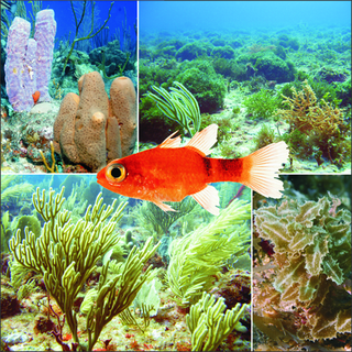
Saba Bank in the Caribbean Netherlands is the largest submarine atoll in the Atlantic Ocean and has some of the richest diversity of marine life in the Caribbean Sea. In 2010 it was designated as "Saba Bank National Park", one of the National Parks of the Netherlands and was officially recognized as such in 2012.

Mount Scenery is a dormant volcano in the Caribbean Netherlands. Its lava dome forms the summit of the Saba island stratovolcano. At an elevation of 887 m (2,910 ft), it is the highest point in both the Kingdom of the Netherlands, and, since the dissolution of the Netherlands Antilles on 10 October 2010, the highest point in the Netherlands proper.

Zion's Hill, also known by its former name Hell's Gate, is a town on the Dutch Caribbean island of Saba. Locally, it is divided into Upper Hell's Gate and Lower Hell's Gate.
The Saba National Marine Park encompasses the waters and sea bed encircling the Caribbean island of Saba, Caribbean Netherlands, from the high water mark to 200 feet (61 m) deep. In total, the marine park covers approximately 5 square miles (13 km2). At the time of its creation in 1987, the government passed the Marine Environment Ordinance to protect the coral reefs and other marine life within the park. The Saba Conservation Foundation manages the Saba National Marine Park, as well as the island's hyperbaric facility, and natural sites on land.
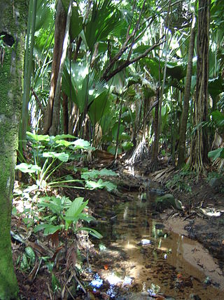
The wildlife of Seychelles comprises the flora and fauna of the Seychelles islands off the eastern coast of Africa in the western Indian Ocean.

The Caribbean Netherlands is a geographic region of the Netherlands located outside of Europe, in the Caribbean, consisting of three so-called special municipalities. These are the islands of Bonaire, Sint Eustatius and Saba, as they are also known in legislation, or the BES islands for short. The islands are officially classified as public bodies in the Netherlands and as overseas territories of the European Union; as such, European Union law does not automatically apply to them.
STENAPA is the national parks organisation of Sint Eustatius, a small Dutch island in the Caribbean. The island is situated within the inner arc of the Leeward Island chain of the Lesser Antilles, West Indies. Sint Eustatius is south of the island of Saba and north of the island of Saint Kitts. The island of St. Eustatius is now part of the country of the Netherlands, as a bijzondere gemeente or "special municipality".

Tortuguero National Park is a national park in the Limón Province of Costa Rica. It is situated within the Tortuguero Conservation Area of the northeastern part of the country. Despite its remote location, reachable only by airplane or boat, it is the third-most visited park in Costa Rica. The park has a large variety of biological diversity due to the existence within the reserve of eleven different habitats, including rainforest, mangrove forests, swamps, beaches, and lagoons. Located in a tropical climate, it is very humid, and receives up to 250 inches (6,400 mm) of rain a year.

Half Moon Caye is an island and natural monument of Belize located at the southeast corner of Lighthouse Reef Atoll. This natural monument was the first nature reserve to have been established in Belize under the National Park Systems Act in 1981 and first marine protected area in Central America. This is also Belize's oldest site of wildlife protection since it was first designated as a bird sanctuary in 1924 to protect the habitat of the red-footed booby birds.

Washington Slagbaai National Park is a national park and ecological reserve on the northwestern part of the island of Bonaire in the Caribbean Netherlands. The 5,643 hectares (21.79 sq mi) park covering approximately a fifth of the island of Bonaire is managed by STINAPA Bonaire, a non-profit foundation, on behalf of the Bonaire government. Established in 1969, Washington Slagbaai National Park was the first nature reserve to be established in the former Netherlands Antilles.

Coral reefs in India are one of the most ancient and dynamic ecosystems of India. The coral reefs not only provide a sanctuary to a myriad of marine life but also play a key role in protecting the coastline from erosion. India has about 7517 km of coastline including islands but mainland coast is 6100 km.
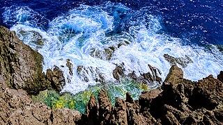
The Flat Point Tide Pools are located on the coast of Saba, in the Dutch Caribbean. The are located on the Flat Point peninsula Lower Hell's Gate. These tide pools feature large lava rock formations filled with colorful saltwater pools. The site was formed during volcanic activity about 5,000 years ago. A large lava flow went down the northeast side of the island into the ocean, forming the Flat Point peninsula as it cooled. Today the Flat Point Tide Pools are home to diverse marine life, and are a popular hiking location. The site is accessible via the Flat Point Trail below Saba's airport.

Flat Point is an area on the northeastern coast of Saba, an island in the Dutch Caribbean. It is located in the lower part of the Hell's Gate village, known as Lower Hell's Gate. Flat Point is the location of Juancho E. Yrausquin Airport, the Tide Pools, ruins of a 17th-18th century sugar and indigo plantation, and Cove Bay.

Well's Bay is a coastal bay on the island of Saba in the Dutch Caribbean. It is located on the northwestern coast of the island. The bay is one of a few places for swimming on Saba. Sometimes Well's Bay has a small beach, known locally as the “wandering beach” due to the black sand that appears and disappears seasonally and sporadically.