William Butterfield was a British Gothic Revival architect and associated with the Oxford Movement. He is noted for his use of polychromy.
Marston is a village in the civil parish of Old Marston about 2 miles (3 km) northeast of the centre of Oxford, England. It was absorbed within the city boundaries in 1991. It is commonly called Old Marston to distinguish it from the suburb of New Marston that developed between St. Clement's and the village in the 19th and 20th centuries. The A40 Northern Bypass, part of the Oxford Ring Road forms a long north-west boundary of the village and parish and a limb, namely a distributary, of the Cherwell forms the western boundary.

Adderbury is a winding linear village and rural civil parish about 3 miles (5 km) south of Banbury in northern Oxfordshire, England. The settlement has five sections: the new Milton Road housing Development & West Adderbury towards the southwest; East Adderbury to the centre, both with a village green and a manor house; and the new housing Development on the Aynho Road; and the northeast, which is known as Twyford, named after a small outlying settlement by a forked section of the River Cherwell.

Botley is a village in the civil parish of Botley and North Hinksey, in the Vale of White Horse district, in the county of Oxfordshire, England, just west of the Oxford city boundary. Historically part of Berkshire, it stands on the Seacourt Stream, a stream running off the River Thames. The intersection of the A34 and A420 is to the village's north.

Islip is a village and civil parish on the River Ray, just above its confluence with the River Cherwell in Oxfordshire, England. It is about 2 miles (3 km) east of Kidlington and about 5 miles (8 km) north of Oxford. The 2011 Census recorded the parish's population as 652.

Headington is an eastern suburb of Oxford, England. It is at the top of Headington Hill overlooking the city in the Thames valley below, and bordering Marston to the north-west, Cowley to the south, and Barton and Risinghurst to the east. The life of the large residential area is centred upon London Road, the main road between London and Oxford.
Wheatley is a village and civil parish in Oxfordshire, about 5 miles (8 km) east of Oxford. The parish includes the hamlet of Littleworth, which is immediately to the west of Wheatley village. The 2011 census recorded the parish population as 3,913.

New Marston is a suburb about 1.25 miles (2 km) northeast of the centre of Oxford, England.

St Clement's is a district in Oxford, England, on the east bank of the River Cherwell. "St Clement's" is usually taken to describe a small triangular area from The Plain bounded by the Cherwell in the West, Cowley Road in the East. to the foot of Headington Hill in the South. It also refers to the ecclesiastical parish of St Clement's which includes some neighbouring areas and is used in the names of local City and County electoral districts.
St Barnabas Church is a Church of England parish church in Jericho, central Oxford, England, located close to the Oxford Canal.

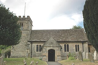
Oddington is a village and civil parish about 5 miles (8 km) south of Bicester in Oxfordshire, England. The village is close to the River Ray on the northern edge of Otmoor. The 2011 Census recorded the parish's population as 129.

John Chessell Buckler was a British architect, the eldest son of the architect John Buckler. J. C. Buckler initially worked with his father before taking over his practice. His work included restorations of country houses and at the University of Oxford.

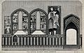
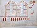
All Saints Church is a former church on the north side of the High Street in central Oxford, England, on the corner of Turl Street. It is now the library of Lincoln College. This former church is Grade I listed.

Headington Quarry is a residential district of Oxford, England, located east of Headington and west of Risinghurst, just inside the Oxford ring road in the east of the city. To the south is Wood Farm. Today the district is also known colloquially as "Quarry". The area, now residential, is considerably uneven due to previous quarrying in the area.
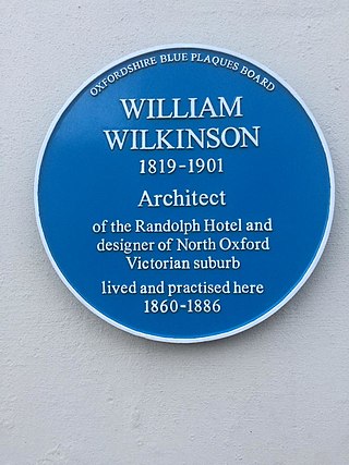
William Wilkinson (1819–1901) was a British Gothic Revival architect who practised in Oxford, England.

St Andrew's Church, Oxford is an evangelical Church of England parish church in Oxford, England. It was consecrated in 1907 and is located on the southeast corner of Linton Road and Northmoor Road in the suburb of North Oxford.
St Clement's Church is an evangelical Church of England parish church situated just to the east of central Oxford, England.
John Gibbs was a British Gothic Revival architect based in Wigan, Manchester, and Oxford, England.

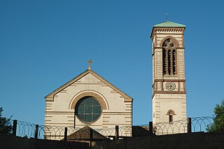
The Church of St Anthony of Padua, Oxford is a yellow brick-built Catholic church in suburb of Headington, east Oxford, Oxfordshire, England. The church building is located in Headley Way.
Thomas Rayson was an architect who practised in Oxford, England, and also a watercolourist.