
The Cathedral Church of St. Barnabas is a cathedral of the Roman Catholic Church in the city of Nottingham in Nottinghamshire, England. It is the mother church of the Diocese of Nottingham and seat of the Bishop of Nottingham. The cathedral is a grade-II* listed building.

Wellow is a village in Nottinghamshire, England. According to the 2001 census it had a population of 444, increasing to 470 at the 2011 census, but falling slightly to 463 at the 2021 census.

Ollerton and Boughton is a civil parish in the Newark and Sherwood district of Nottinghamshire, England. The main settlements are the town of Ollerton and the villages of New Ollerton and Boughton. The civil parish was formed in 1996, when the civil parishes of Ollerton and Boughton were merged. The population of the civil parish at the time of the 2011 census was recorded as 9,840, and this increased to 11,089 residents at the 2021 census.

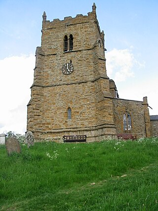
Walesby is a village and civil parish in Nottinghamshire, England. At the time of the 2001 census it had a population of 1,255 people, increasing slightly to 1,266 at the 2011 census, and dropping to 1,218 at the 2021 census. It is located 16 miles (26 km) north of Newark. The parish church of St Edmund is Perpendicular in style.

Skendleby is a small village and civil parish in the East Lindsey district of Lincolnshire, England. It is situated near to the A158 and lies 35 miles (56 km) east from the county town Lincoln, and about 4 miles (6 km) north-east from the town of Spilsby. The village stands near the south-eastern edge of the Lincolnshire Wolds.
Walesby is a village and civil parish in the West Lindsey district of Lincolnshire, England. The population of the civil parish at the 2011 census was 249. It lies in the Lincolnshire Wolds, 3 miles (5 km) north-east from Market Rasen and 7 miles (11 km) south from Caistor. Tealby parish lies to the south-east. The parish covers about 3,600 acres (15 km2) and includes the hamlets of Risby and Otby.

Thomas Chambers Hine was an architect based in Nottingham.
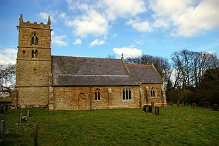
The Church of St Mary and All Saints, Hawksworth is the Church of England parish church in Hawksworth, Nottinghamshire. It is Grade II* listed by the Department for Digital, Culture, Media and Sport as a particularly significant building of more than local interest.
St. Edmund's Church or similar variations can refer to numerous churches:

Charles Hodgson Fowler was a prolific English ecclesiastical architect who specialised in building and, especially, restoring churches.

St Mary's Church, Lead, is a redundant Anglican chapel standing in an isolated position in fields some 0.75 miles (1.2 km) to the west of the village of Saxton, North Yorkshire, England. Though technically a chapel, it is generally referred to as a church. It is managed by The Churches Conservation Trust, and is recorded in the National Heritage List for England as a designated Grade II* listed building. The chapel stands close to the site of the battle of Towton of 1461, which was part of the Wars of the Roses. In the 1930s it was saved from neglect by a local group of ramblers, and is known locally as the Ramblers' Church.

Claxby, or Claxby by Normanby, is a village and civil parish in the West Lindsey district of Lincolnshire, England. The population of the civil parish taken at the 2011 census was 221. It is situated approximately 4 miles (6 km) north from the town of Market Rasen and 5 miles (8 km) south from the town of Caistor.
Normanby le Wold is a village and civil parish in the West Lindsey district of Lincolnshire, England. It is in the Lincolnshire Wolds, an Area of Outstanding Natural Beauty, and about 5 miles (8.0 km) south from the town of Caistor, and 17 miles (27 km) north-east from the city and county town of Lincoln. It is in the civil parish of Claxby by Normanby.

North Willingham is a village and civil parish in the West Lindsey district of Lincolnshire, England. The population of the civil parish was at 181 during the 2011 census. It is situated 3.5 miles (6 km) east from the town of Market Rasen on the A631 road between Market Rasen and Louth.

All Saints’ Church, Thrumpton is a Grade II* listed parish church in the Church of England in Thrumpton, Nottinghamshire. A stone font in the churchyard is Grade II listed.

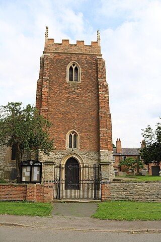
The Church of St Edmund is on Old Manor Road, Mansfield Woodhouse, Nottinghamshire, England. It is an active Church of England parish church in the deanery of Mansfield, the Archdeaconry of Newark, and the Southwell and Nottingham diocese. Its benefice has two churches, St Edmund’s is the main parish church, also the Church of St Chad, Pleasley Vale. The church is recorded in the National Heritage List for England as a designated Grade II* listed building.

West Markham or Markham Clinton is a village and civil parish 23 miles (37 km) north east of Nottingham, in the Bassetlaw district, in the county of Nottinghamshire, England. In the 2011 census, the parish had a population of 170, and this increased marginally to 175 residents at the 2021 census. The parish touches Bevercotes, West Drayton, East Markham, Bothamsall, Walesby and Tuxford. The A1 previously went through the village but its now been bypassed.

