
County Antrim is one of the six counties of Northern Ireland, located within the historic province of Ulster. Adjoined to the north-east shore of Lough Neagh, the county covers an area of 3,086 square kilometres (1,192 sq mi) and has a population of 651,321, as of the 2021 census. County Antrim has a population density of 211 people per square kilometre or 546 people per square mile. It is also one of the thirty-two traditional counties of Ireland.

County Down is one of the six counties of Northern Ireland, one of the nine counties of Ulster and one of the traditional thirty-two counties of Ireland. It covers an area of 961 sq mi (2,490 km2) and has a population of 552,261. It borders County Antrim to the north, the Irish Sea to the east, County Armagh to the west, and County Louth across Carlingford Lough to the southwest.

Lisburn is a city in Northern Ireland. It is 8 mi (13 km) southwest of Belfast city centre, on the River Lagan, which forms the boundary between County Antrim and County Down. First laid out in the 17th century by English and Welsh settlers, with the arrival of French Huguenots in the 18th century, the town developed as a global centre of the linen industry.

Portadown is a town in County Armagh, Northern Ireland. The town sits on the River Bann in the north of the county, about 24 mi (39 km) southwest of Belfast. It is in the Armagh City, Banbridge and Craigavon Borough Council area and had a population of about 22,000 at the 2011 Census. For some purposes, Portadown is treated as part of the "Craigavon Urban Area", alongside Craigavon and Lurgan.

Lough Neagh is a freshwater lake in Northern Ireland and is the largest lake on the island of Ireland and in the United Kingdom. It has a surface area of 151 square miles and is about 19 miles (31 km) long and 9 miles (14 km) wide. According to Northern Ireland Water, it supplies 40.7% of Northern Ireland's drinking water. Its main inflows are the Upper River Bann and Blackwater, and its main outflow is the Lower Bann. There are several small islands, including Ram's Island, Coney Island and Derrywarragh Island. The lake bed is owned by the 12th Earl of Shaftesbury and the lake is managed by Lough Neagh Partnership. Its name comes from Irish Loch nEachach, meaning "Eachaidh's lake".

Royal Hillsborough, more commonly known simply as Hillsborough, is a village and civil parish in County Down, Northern Ireland, 19 km (12 mi) from the city of Belfast. It is within the Lisburn and Castlereagh District Council area. The village is noted for its Georgian architecture. It is home to Hillsborough Castle, the British royal family's official residence in Northern Ireland, and residence of the British Secretary of State for Northern Ireland.

The River Lagan is a major river in Northern Ireland which runs 53.5 mi (86.1 km) from the Slieve Croob mountain in County Down to Belfast where it enters Belfast Lough, an inlet of the Irish Sea. The Lagan forms much of the border between County Antrim and County Down in the east of Ulster. It rises as a tiny, fast-moving stream near to the summit of Slieve Croob; Transmitter Road runs nearby. It runs to Belfast through Dromara, Donaghcloney and Dromore. On the lower slopes of the mountain, it combines with a branch from Legananny Mountain, just opposite Slieve Croob. The river then turns east to Magheralin into a broad plain between the plateaus of Antrim and Down.

Belfast Castle is a mansion located in Cave Hill Country Park in Belfast, Northern Ireland, in a prominent position 400 feet (120 m) above sea level. Its location provides unobstructed views over the City of Belfast and Belfast Lough. There have been several different structures called "Belfast Castle" over the centuries, located on different sites. The current "castle" is a Victorian structure, built between 1867 and 1870 on the slopes of Cave Hill, and is Grade A listed. The main entrance into the Belfast Castle Demesne is now where Innisfayle Park meets Downview Park West, just off the Antrim Road. The original main entrance into the current demesne was formerly on the Antrim Road itself, where Strathmore Park now meets the Antrim Road.

Aghalee is a village, townland and civil parish in County Antrim, Northern Ireland. It is three miles from the southeast corner of Lough Neagh on the main road between Lurgan and Antrim and about 13 kilometres west of Lisburn. The village lies on the steep wooded slopes of Friar's Glen and is beside the now disused Lagan Navigational Canal. In the 2001 census, Aghalee had a population of 774.

The River Farset is a river in Belfast, Northern Ireland. It is a late tributary of the River Lagan.
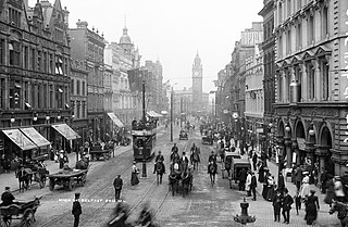
Belfast is the capital of Northern Ireland, and throughout its modern history has been a major commercial and industrial centre. In the late 20th century manufacturing industries that had existed for several centuries declined, particularly shipbuilding. The city's history has occasionally seen conflict between different political factions who favour different political arrangements between Ireland and Great Britain. Since the Good Friday Agreement, the city has been relatively peaceful and major redevelopment has occurred, especially in the inner city and dock areas.

Moira is a village and civil parish in County Down, Northern Ireland. It is in the northwest of the county, near the border with counties Antrim and Armagh. The M1 motorway and Belfast–Dublin railway line are nearby. The population was 4,591 at the 2011 Census.

Stewartstown is a village in Northern Ireland, close to the western shore of Lough Neagh, about 5 miles (8 km) from Cookstown, 3 miles (5 km) from Coalisland and 7 miles (11 km) from Dungannon. Established by Scottish Planters early in the 17th century, its population peaked before the Great Famine of the 1840s at over 1000. In the 2011 Census the town had a population of 650 people. Formerly in the historic County Tyrone, today it is in local-government district of Mid Ulster.

Dál nAraidi or Dál Araide, sometimes latinised as Dalaradia or anglicised as Dalaray, was a Cruthin kingdom, or possibly a confederation of Cruthin tribes, in north-eastern Ireland during the Middle Ages. It was part of the over-kingdom of Ulaid, and its kings often contended with the Dál Fiatach for the over-kingship of the province. At its greatest extent, the borders of Dál nAraidi roughly matched those of County Antrim, and they seemed to occupy the same area as the earlier Robogdii of Ptolemy's Geography, a region shared with Dál Riata. Their capital was Ráth Mór outside Antrim, and their eponymous ancestor is claimed as being Fiachu Araide.

Ballyronan is a village and townland in County Londonderry, Northern Ireland, on the north western shore of Lough Neagh. The village is 5 miles (8 km) from Magherafelt and 12 miles (19 km) from Cookstown. It is situated within Mid-Ulster District.

Nendrum Monastery was a Christian monastery on Mahee Island in Strangford Lough, County Down, Northern Ireland. Medieval records say it was founded in the 5th century, but this is uncertain. The monastery came to an end at some time between 974 and 1178, but its church served a parish until the site was abandoned in the 15th century. Some remains of the monastery can still be seen.
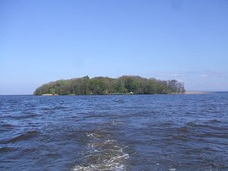
Coney Island is an island in Lough Neagh, Northern Ireland. It is about 1 km offshore from Maghery in County Armagh, is thickly wooded and of nearly 9 acres (36,000 m2) in area. It lies between the mouths of the River Blackwater and the River Bann in the south-west corner of Lough Neagh. Boat trips to the island are available at weekends from Maghery Country Park or Kinnego Marina. The island is owned by the National Trust and managed on their behalf by Armagh City, Banbridge and Craigavon Borough Council. Coney Island Flat is a rocky outcrop adjacent to the island. Although Samuel Lewis called Coney Island the only island in County Armagh, Armagh's section of Lough Neagh also includes Croaghan Island, as well as the marginal cases of Padian and Derrywarragh Island.

Poyntzpass is a small village on the border between southern County Armagh and County Down in Northern Ireland. It is situated in the civil parish of Ballymore and the historic barony of Orior Lower within the Armagh City, Banbridge and Craigavon area. It had a population of 552 people in the 2011 census. It was a part of the South Armagh constituency and is now part of the Newry and Armagh constituency.
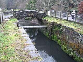
The Lagan Canal was a 44-kilometre (27 mi) canal built to connect Belfast to Lough Neagh. The first section, which is a river navigation, was opened in 1763, and linked Belfast to Lisburn. The second section from Lisburn to Lough Neagh includes a small amount of river navigation, but was largely built as a canal. At its peak it was one of the most successful of the Irish canals, but ultimately it was unable to compete with road and rail transport, and the two sections were closed in 1954 and 1958. The central section from Sprucefield to Moira was destroyed by the construction of the M1 motorway in the 1960s. Responsibility for most of its remains passed first to the Department of Agriculture and then to the Department of Culture, Arts and Leisure, although the section between Aghalee Bridge and Lough Neagh, including the final ten locks, passed into private ownership. There is an active campaign to re-open the canal, including reinstatement of the central section.
Ballyscullion House refers to two country houses built for the Hervey family near Bellaghy in County Londonderry, Northern Ireland, close to Lough Beg at north-west corner of Lough Neagh.


