
Bournemouth is a coastal resort town in the Bournemouth, Christchurch and Poole council area of Dorset, England. At the 2011 census, the town had a population of 183,491, making it the largest town in Dorset. It is situated on the English south coast, equidistant from Dorchester and Southampton. Bournemouth is part of the South East Dorset conurbation, which has a population of 465,000.

Nether Stowey is a large village in the Sedgemoor district of Somerset, South West England. It sits in the foothills of the Quantock Hills, just below Over Stowey. The parish of Nether Stowey covers approximately 4 km², with a population of 1,373.

Poole is a large coastal town and seaport in Dorset, on the south coast of England. The town is 21 miles (34 km) east of Dorchester and adjoins Bournemouth to the east. Since 1 April 2019, the local authority is Bournemouth, Christchurch and Poole Council which is a unitary authority. Poole had an estimated population of 151,500 making it the second-largest town in the ceremonial county of Dorset. Together with Bournemouth and Christchurch, the conurbation has a total population of nearly 400,000.

Sherborne is a market town and civil parish in north west Dorset, in South West England. It is sited on the River Yeo, on the edge of the Blackmore Vale, 6 miles east of Yeovil. The parish includes the hamlets of Nether Coombe and Lower Clatcombe. The A30 road, which connects London to Penzance, runs through the town. In the 2011 census the population of Sherborne parish and the two electoral wards was 9,523. 28.7% of the population is aged 65 or older.
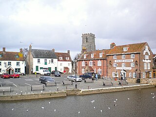
Wareham is a historic market town and, under the name Wareham Town, a civil parish, in the English county of Dorset. The town is situated on the River Frome eight miles (13 km) southwest of Poole.

Castle Cary is a market town and civil parish in south Somerset, England, 5 miles (8 km) north west of Wincanton and 8 miles (12.9 km) south of Shepton Mallet, at the foot of Lodge Hill and on the River Cary, a tributary of the Parrett.
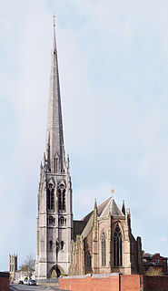
St Walburge's Church is a Roman Catholic church in Preston, Lancashire, England, northwest of the city centre on Weston Street. The church was built in the mid-19th century to a design by the Gothic Revival architect Joseph Hansom, the designer of the hansom cab, and is famous as having the tallest spire of any parish church in England. St Walburge's is recorded in the National Heritage List for England as a Grade I listed building.

Lytchett Matravers is a village and civil parish in Dorset, England. The 2011 census recorded the parish as having 1,439 households and a population of 3,424.

Worth Matravers is a village and civil parish in the English county of Dorset. The village is situated on the cliffs west of Swanage. It comprises limestone cottages and farm houses and is built around a pond, which is a regular feature on postcards of the Isle of Purbeck.

Kemsing is a village and civil parish in the Sevenoaks district of Kent, England. The parish lies on the scarp face of the North Downs, 20 miles south east of Central London, 4 miles (6 km) north east of Sevenoaks. Also in the parish are the hamlets of Heaverham, 1 mile (2 km) to the east, and Noah's Ark 0.5 miles (1 km) to the south. The population of the civil parish in 2001 was 4014 persons, increasing to a population of 4,218 at the 2011 Census.

Morden is a civil parish in the Purbeck district of south Dorset, England. Morden is about 6 miles (10 km) north-west of Poole. At the 2011 census the civil parish had 141 households and a population of 323.

Tollard Royal is a village and civil parish on Cranborne Chase, Wiltshire, England. The parish is on Wiltshire's southern boundary with Dorset and the village is 6 miles (10 km) southeast of the Dorset town of Shaftesbury, on the B3081 road between Shaftesbury and Sixpenny Handley.

Ebbesbourne Wake is a village and civil parish in Wiltshire, England, some 10 miles (16 km) south-west of Salisbury, near the head of the valley of the small River Ebble. The parish includes the hamlets of Fifield Bavant and West End.
Evercreech is a village and civil parish 3 miles (4.8 km) south east of Shepton Mallet, and 5 miles (8.0 km) north east of Castle Cary, in the Mendip district of Somerset, England. The parish includes the hamlet of Stoney Stratton and the village of Chesterblade.

Downton is a village and civil parish on the River Avon in southern Wiltshire, England, about 6 miles (10 km) southeast of the city of Salisbury. The parish is on the county boundary with Hampshire and is close to the New Forest; it includes the villages of Wick and Charlton-All-Saints, and the small ancient settlement of Witherington. The Trafalgar Park estate erased the former settlement of Standlynch. The parish church, Trafalgar House, and two more houses are Grade I listed.

Longbridge Deverill is a village and civil parish about 2.5 miles (4.0 km) south of Warminster in Wiltshire, England. It is on the A350 primary route which connects the M4 motorway and west Wiltshire with Poole, Dorset.
Otterhampton is a village and civil parish in the Sedgemoor district of Somerset, England, between Bridgwater and the Steart Peninsula. The civil parish includes the larger village of Combwich and the small village of Steart.
William Henry Romaine-Walker (1854–1940) was an English architect and interior decorator.

Shrewton is a village and civil parish on Salisbury Plain in Wiltshire, England, around 6 miles (9.7 km) west of Amesbury and 14 miles (23 km) north of Salisbury. It lies on the A360 road between Stonehenge and Tilshead. It is close to the source of the River Till, which flows south to Stapleford.

The Church of St Giles is the Church of England parish church for the village of Wimborne St Giles, Dorset. Originally founded in the 13th century and rebuilt several times over the ensuing centuries, the present church is a mixture of Georgian and Gothic Revival architecture. It is located at the start of the main driveway to St Giles House, the seat of the Earl of Shaftesbury, at the end of a row of Stuart-era almshouses.


