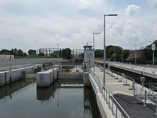
Bow Back Rivers or Stratford Back Rivers is a complex of waterways between Bow and Stratford in east London, England, which connect the River Lea to the River Thames. Starting in the twelfth century, works were carried out to drain Stratford Marshes and several of the waterways were constructed to power watermills. Bow Creek provided the final outfall to the Thames, and the other channels were called Abbey Creek, Channelsea River, City Mill River, Prescott Channel, Pudding Mill River, Saint Thomas Creek, Three Mills Back River, Three Mills Wall River and Waterworks River.
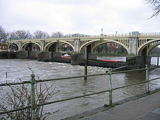
Richmond Lock and Footbridge is a lock, rising and falling low-tide barrage integrating controlled sluices and pair of pedestrian bridges on the River Thames in south west London, England and is a Grade II* listed structure. It is the furthest downstream of the forty-five Thames locks and the only one owned and operated by the Port of London Authority. It was opened in 1894 and is north-west of the centre of Richmond in a semi-urban part of south-west London. Downstream are Syon Park and Kew Gardens on opposite banks. It connects the promenade at Richmond with the neighbouring district of St. Margarets on the west bank during the day and is closed at night to pedestrians – after 19:30 GMT or after 21:30 when BST is in use. At high tide the sluice gates are raised and partly hidden behind metal arches forming twin footbridges.

Bray Lock is a lock and weir on the River Thames in England near Bray and Dorney Reach, and is just above the M4 Bridge across the Thames. The lock is on the Buckinghamshire side of the river on the opposite bank from Bray itself and Maidenhead which are in Berkshire. Here, the county line stands roughly halfway between the lock and the opposite bank, following the course of the Thames itself. The pound lock was built by the Thames Navigation Commission relatively late, in 1845. The lock keeper's cottage is on an island between the lock and the weir.
This article lists the islands in the River Thames, or at the mouth of a tributary, in England. It excludes human-made islands built as part of the building of forty-five two-gate locks which each accompany a weir, and islets subordinate to and forming part of the overall shape of another. The suffix -ey is common across England and Scotland and cognate with ait and meaning island, a term – as ait or eyot – unusually well-preserved on the Thames. A small minority of list entries are referred to as Island, Ait or Eyot and are vestiges, separated by a depression in the land or high-water-level gully.

Whitchurch Lock is a lock and weir on the River Thames in England. It is a pound lock, built by the Thames Navigation Commissioners in 1787. It is on an island near the Oxfordshire village of Whitchurch-on-Thames and is accessible only by boat.

The River Leach is a river tributary to the River Thames, in England which runs mostly in Gloucestershire. It is approximately 18 miles (29 km) long, springing from the limestone uplands of the Cotswolds. In parts of its course it becomes a seasonal bourn, only running above ground when there is sufficient rainfall. Despite its small size it gives its name to two towns and a pair of villages.

Radcot Bridge is a crossing of the River Thames in England, south of Radcot, Oxfordshire, and not far north of Faringdon, Oxfordshire. It carries the A4095 road across the river on the reach above Radcot Lock. Adjoining the bridge is the Swan Inn and slight earthworks of Matilda's Castle.

Cookham Lock is a lock with weirs situated on the River Thames near Cookham, Berkshire, about a half-mile downstream of Cookham Bridge. The lock is set in a lock cut which is one of four streams here and it is surrounded by woods. On one side is Sashes Island and on the other is Mill Island connected to Formosa Island, the largest on the non-tidal Thames.

The Thames Path is a National Trail following the River Thames from its source near Kemble in Gloucestershire to the Thames Barrier at Charlton, south east London. It is about 184 miles (296 km) long. A path was first proposed in 1948 but it only opened in 1996.

The Thames Conservancy was a historical body responsible for the management of the River Thames in England. It was founded in 1857, initially replacing the jurisdiction of the City of London up to Staines and later taking responsibility for the whole river from Cricklade in Wiltshire to the sea at Yantlet Creek on the Isle of Grain. Responsibilities were reduced when the Tideway was transferred to the Port of London Authority in 1909 and in 1974 the Conservancy was taken into the Thames Water Authority.

Shepperton Lock is a lock on the River Thames, in England by the left bank at Shepperton, Surrey. It is across the river from Weybridge which is nearby linked by a passenger ferry.

St John's Lock, below the town of Lechlade, Gloucestershire, is the furthest upstream lock on the River Thames in England. The name of the lock derives from a priory that was established nearby in 1250, but which no longer exists. The lock was built of stone in 1790 by the Thames Navigation Commission.

The River Wey Navigation and Godalming Navigation together provide a 20-mile (32 km) continuous navigable route from the River Thames near Weybridge via Guildford to Godalming. Both waterways are in Surrey and are owned by the National Trust. The River Wey Navigation connects to the Basingstoke Canal at West Byfleet, and the Godalming Navigation to the Wey and Arun Canal near Shalford. The Navigations consist of both man-made canal cuts and adapted parts of the River Wey.

Old Windsor Lock is a lock on the River Thames in England on the right bank beside Old Windsor, Berkshire. The lock marks the downstream end of the New Cut, a meander cutoff built in 1822 by the Thames Navigation Commissioners which created Ham Island. The lock and a wider footbridge give access to the island. Two weirs are associated; the smaller adjoins and the larger is upstream. The lock is the ninth lowest of the forty-five on the river.

Buscot Lock is a lock on the River Thames in England, near the village of Buscot, Oxfordshire.

Halfpenny Bridge is a bridge across the River Thames, at Lechlade, Gloucestershire, England. The bridge and its toll house are a Grade II listed building. It marks the start of the navigable Thames, although if the waters are high, the Thames can continue to be travelled by small and unpowered craft as far as Cricklade, over 10 miles (16 km) South-west.
Buscot is an English village and civil parish on the River Thames, about 1.5 miles (2.4 km) south-east of Lechlade. Buscot was part of Berkshire until the 1974 boundary changes transferred it to Oxfordshire. Two houses there contain notable collections of paintings.

The Hackney Cut is an artificial channel of the Lee Navigation built in England in 1769 by the River Lea Trustees to straighten and improve the Navigation. It begins at the Middlesex Filter Beds Weir, below Lea Bridge, and is situated in the (modern) London Borough of Hackney. When built it contained two pound locks and a half-lock, but was rebuilt to handle larger barges in the 1850s, and now only Old Ford Lock, which is actually a duplicated pair, remains.

Inglesham is a small village and civil parish in the Borough of Swindon, Wiltshire, England, notable for the Grade-I listed St John the Baptist Church. The village is just off the A361 road about 1 mile (1.6 km) south-west of Lechlade in Gloucestershire. Most of the population lives in the hamlet of Upper Inglesham, which is on the main road about 1.3 miles (2 km) south of the village.

The Trout Inn is a pub next to the River Thames at Lechlade in the English county of Gloucestershire. The Grade II listed stone building consists of two two-storey structures, one late medieval and the other added in the 18th century. The building began as an almshouse for workers on the adjoining St John's Bridge in the 1220s, before becoming part of a priory and then an inn.

