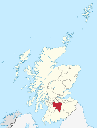
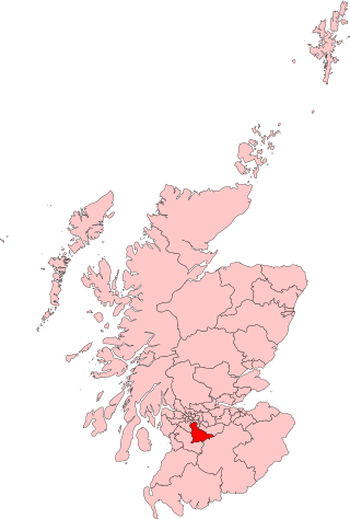
South Lanarkshire is one of 32 unitary authorities of Scotland. It borders the south-east of the Glasgow City council area and contains some of Greater Glasgow's suburban towns, as well as many rural towns and villages. It also shares borders with Dumfries and Galloway, East Ayrshire, East Renfrewshire, North Lanarkshire, the Scottish Borders and West Lothian. It includes most of the historic county of Lanarkshire.

East Kilbride is the largest town in South Lanarkshire in Scotland, and the country's sixth-largest locality by population. It was also designated Scotland's first new town on 6 May 1947. The area lies on a raised plateau to the south of the Cathkin Braes, about eight miles southeast of Glasgow and close to the boundary with East Renfrewshire.

Cambuslang is a town on the south-eastern outskirts of Greater Glasgow, Scotland. With approximately 30,000 residents, it is the 27th largest town in Scotland by population, although, never having had a town hall, it may also be considered the largest village in Scotland. It is within the local authority area of South Lanarkshire and directly borders the town of Rutherglen to the west. Historically, it was a large civil parish incorporating the nearby hamlets of Newton, Flemington, Westburn and Halfway.

The Rotten Calder is a river to the east of East Kilbride, South Lanarkshire, Scotland and along with the Rotten Burn it forms the southern and western boundaries of Blantyre.
East Kilbride, Strathaven and Lesmahagow is a county constituency of the House of Commons of the Parliament of the United Kingdom, which was first used in the general election of 2005. It replaced East Kilbride and some of Clydesdale, and it elects one Member of Parliament (MP) by the first past the post system of election.

Burnside is a mostly residential area in the town of Rutherglen in South Lanarkshire, Scotland. Including the neighbourhoods of High Burnside and High Crosshill, respectively south and north-west of its main street, it borders Overtoun Park in Rutherglen plus several other residential areas of the town, as well as western parts of neighbouring Cambuslang.
Kelvin is an area of the new town of East Kilbride, in South Lanarkshire, Scotland.

Stewartfield is an area of the Scottish new town East Kilbride, in South Lanarkshire.
Claremont High School was a non-denominational, state-funded secondary school based in the St Leonards area of East Kilbride. It closed in June 2007 and merged with Hunter High School to form the new Calderglen High School, although Calderglen met in the Claremont building until February 2008 when the new building opened on the same site. It was originally one of six state Secondary schools in East Kilbride until, after a school modernisation program by South Lanarkshire Council, they were merged into three schools.

Calderglen High School is a state-run secondary school in the St Leonards area of the Scottish new town East Kilbride, in South Lanarkshire. The complex of buildings is situated on the precipitous bank of the Rotten Calder Water, overlooking a meander named the 'School Bend'. The school derives its name from the Calder Glen (gorge) which the river occupies, which is a site of special scientific interest (SSSI). The school has a potential pupil roll of approximately 1800, with 130 teachers, making it one of the largest secondary institutions in Europe. The school's houses are named Jura, Uist, Harris, Tiree and Lewis.
Chapelton is a small village in South Lanarkshire, Scotland. The village is located approximately halfway between the towns of East Kilbride and Strathaven, on the A726. It resides in the former parish of Glassford, which takes its name from the nearby village of the same name.

Calderwood is a neighbourhood of the Scottish new town of East Kilbride, in South Lanarkshire. It lies on its north-east edge and is one of the largest areas of the town.

Hunter High School was a non-denominational secondary school which served the Calderwood, East Mains and parts of the St Leonards and Stewartfield areas of the new town of East Kilbride from 1963 to 2007. The school started as a four-year Secondary school and was extended in 1966 prior to amalgamation with the old East Kilbride Village school to form a full six-year Comprehensive. In 2008, it merged with Claremont High School to form the new Calderglen High School.

Auldhouse is a hamlet in South Lanarkshire, around 0.5 miles (0.80 km) to the south of the suburban edge of East Kilbride.

Calderwood Castle was located in East Kilbride, Scotland. The castle was situated near the banks of the Rotten Calder Water in what is now Calderglen Country Park. Most likely constructed in the early to mid fifteenth century by the Maxwell family, the original peel tower collapsed in 1773. It was replaced by an extension to a large 18th-century country house called Calderwood House, which has itself since been demolished along with a later 1840s Gothic Revival addition.

Calderglen Country Park is a country park in the town of East Kilbride, South Lanarkshire, Scotland. It is situated along the eastern edge of the town and is its principal greenspace and recreation area.

Elections to South Lanarkshire Council took place on 4 May 2017 on the same day as the 31 other Scottish local government elections. As with other Scottish council elections, it was held using single transferable vote (STV) – a form of proportional representation – in which multiple candidates are elected in each ward and voters rank candidates in order of preference.

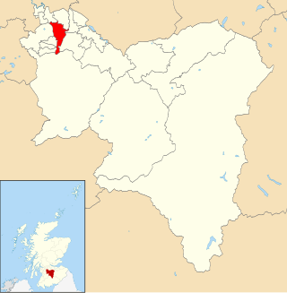
East Kilbride Central North is one of the 20 electoral wards of South Lanarkshire Council. Created in 2007, the ward initially elected four councillors using the single transferable vote electoral system and covers an area with a population of 16,547 people. Following a boundary review, the ward has elected three councillors since 2017.
East Kilbride East is one of the 20 electoral wards of South Lanarkshire Council. Created in 2007, the ward elects three councillors using the single transferable vote electoral system and covers an area with a population of 15,275 people.
Elections to South Lanarkshire Council took place on 5 May 2022 on the same day as the 31 other Scottish local government elections. As with other Scottish council elections, it was held using single transferable vote (STV) – a form of proportional representation – in which multiple candidates are elected in each ward and voters rank candidates in order of preference.