
Lanarkshire, also called the County of Lanark, is a historic county, lieutenancy area and registration county in the Central Lowlands and Southern Uplands of Scotland. The county is no longer used for local government purposes, but gives its name to the two modern council areas of North Lanarkshire and South Lanarkshire.

East Kilbride is the largest town in South Lanarkshire in Scotland, and the country's sixth-largest locality by population. It was also designated Scotland's first new town on 6 May 1947. The area lies on a raised plateau to the south of the Cathkin Braes, about eight miles southeast of Glasgow and close to the boundary with East Renfrewshire.

Fernhill is a residential neighbourhood in the Scottish town of Rutherglen in South Lanarkshire; it is situated south of the River Clyde and borders the Rutherglen neighbourhoods of High Burnside to the north and Cathkin to the east, the Glasgow district of Castlemilk to the west, and the open lands of Fernbrae Meadows to the south. Its location on a steep incline which is part of the Cathkin Braes range of hills offers panoramic views over the south and eastern parts of Greater Glasgow.

Hairmyres railway station is a railway station in the Hairmyres area of East Kilbride, South Lanarkshire, Greater Glasgow, Scotland. The station is managed by ScotRail and is on the Glasgow South Western Line 10 miles (16 km) southeast of Glasgow Central towards East Kilbride.

Busby is a village in East Renfrewshire, Scotland. Busby is in the Glasgow urban area, although it is not administratively part of the city. It lies on the White Cart Water six miles south of Glasgow city centre and 3⁄4 mile northwest of the outskirts of East Kilbride. It directly adjoins the town of Clarkston, with which the village is closely associated.

Stonehouse is a rural village in South Lanarkshire, Scotland. It is on Avon Water in an area of natural beauty and historical interest, near to the Clyde Valley. It is on the A71 trunk road between Edinburgh and Kilmarnock, near the towns of Hamilton, Larkhall and Strathaven. The population of Stonehouse is around 7,500.
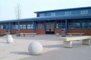
University Hospital Hairmyres is a district general hospital in the Hairmyres neighbourhood of East Kilbride, South Lanarkshire, Scotland. The hospital serves one of the largest elderly populations in Scotland. It is managed by NHS Lanarkshire.
Gardenhall is an area of the Scottish new town East Kilbride, in South Lanarkshire.
Nerston is a village situated on the northern green-belt boundary of the new town of East Kilbride in South Lanarkshire, Scotland.
Philipshill is an area of the Scottish new town East Kilbride, in South Lanarkshire.

Jackton is a small village lying just on the western periphery of East Kilbride in South Lanarkshire, on the B764 road connecting it to the village of Eaglesham. It is also adjacent to Thorntonhall, and the two villages share a newsletter, the Peel News, derived from the name of the road connecting the two. The settlement, as well as an area of surrounding farmland going as far as Lindsayfield was designated as a Community Growth Area for East Kilbride in South Lanarkshire's Local Development Plan 2. The development of new build housing, additional retail locations, and a new primary school are planned and under construction as of March 2023. Jackton lies approximately 150 metres (490 ft) above sea level.

The A726 road in Scotland is a major route with several distinct sections with different characteristics and names; owing to its stages of construction, since 2005 it has two separate parts, the first running between Strathaven in South Lanarkshire and Junction 5 of the M77 motorway south of Newton Mearns in East Renfrewshire via East Kilbride, and the other running between Junction 3 of the M77 and the M898 motorway near the Erskine Bridge, via Paisley and Junction 29 of the M8 motorway near Glasgow International Airport.

The A727 road in Scotland runs from East Kilbride in South Lanarkshire, through East Renfrewshire, to Junction 3 of the M77 motorway in Glasgow.

University Hospital Wishaw is a district general hospital in Wishaw, North Lanarkshire, situated between the areas of Craigneuk to the north and Netherton to the south. The hospital, managed by NHS Lanarkshire, is 11 miles southeast of Glasgow.

Calderwood is a neighbourhood of the Scottish new town of East Kilbride, in South Lanarkshire. It lies on its north-east edge and is one of the largest areas of the town.

Margaret McCulloch is a Scottish Labour Party politician. She was a Member of the Scottish Parliament (MSP) for the Central Scotland region 2011–2016.
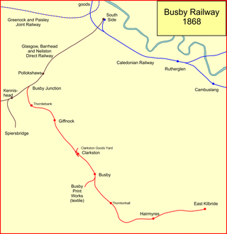
The Busby Railway is a short railway line built to the south of Glasgow, connecting the small villages of Thornliebank, Giffnock, Clarkston and Busby and later Thorntonhall and East Kilbride with the city. It opened in two stages, in 1866 and 1868, and served industry and encouraged residential development.

Whitlawburn is a residential area in the town of Cambuslang in South Lanarkshire, Scotland. It is located south of the town centre on high ground overlooking the Greater Glasgow urban area.

East Kilbride West is one of the 20 electoral wards of South Lanarkshire Council. Created in 2007, the ward elects three councillors using the single transferable vote electoral system and covers an area with a population of 13,737 people.

The A724 road in Scotland runs within South Lanarkshire between Rutherglen and Hamilton. It follows an ancient route which is marked on William Roy's Lowland Map of Scotland (1755) with only minor deviations from its modern course.

