St Michael's Church School

Last updated

St Michael's Church School
Church of St Michael and All Angels 93.jpg
St Michael and All Angels Church
Address
St Michael's Church School
249 Durham Street, Christchurch
Coordinates 43°32′05″S172°38′00″E / 43.53477°S 172.63322°E / -43.53477; 172.63322
Information
TypePrivate Co-educational Primary and Intermediate school
Motto in hoc signo vinces
(Latin for "In this sign you shall conquer")
Established1851;172 years ago (1851)
Ministry of Education Institution no. 4136
PrincipalPenny Tattershaw
School roll158 [1] (April 2023)
Socio-economic decile9
Website Official website

St Michael's is a co-educational Anglican private primary and intermediate day school situated in the city centre of Christchurch, New Zealand. The school provides an education for year zero to year eight. It is associated with the Church of St Michael and All Angels.

Contents

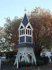
Three of the buildings and structures are registered with the New Zealand Historic Places Trust as heritage items. The church building is registered as a Category I structure. [2] The belfry of the church, built in 1861 and designed by Benjamin Mountfort, is also recognised as a Category I structure. [3] The 1912 Stone School Building, designed by Cecil Wood, is registered as a Category II building. [4]

Belfry Belfry, St Michael's Church.jpg
Belfry
Stone School Building Stone School Building, St Michael's School.jpg
Stone School Building

See also

Related Research Articles

<span class="mw-page-title-main">George Street, Dunedin</span>

George Street is the main street of Dunedin, the second largest city in the South Island of New Zealand. It runs for two and a half kilometres north-northeast from The Octagon in the city centre to the foot of Pine Hill. It is straight and undulates gently as it skirts the edge of the hills to its northwest. South of The Octagon, Princes Street continues the line of George Street south-southwest for two kilometres.

<span class="mw-page-title-main">Heritage New Zealand</span> Crown entity of New Zealand

Heritage New Zealand Pouhere Taonga is a Crown entity with a membership of around 20,000 people that advocates for the protection of ancestral sites and heritage buildings in New Zealand. It was set up through the Historic Places Act 1954 with a mission to "...promote the identification, protection, preservation and conservation of the historical and cultural heritage of New Zealand" and is an autonomous Crown entity. Its current enabling legislation is the Heritage New Zealand Pouhere Taonga Act 2014.

<span class="mw-page-title-main">Moray Place, Dunedin</span> Street in Dunedin, Otago Region, New Zealand

Moray Place is an octagonal street which surrounds the city centre of Dunedin, Otago, New Zealand. The street is intersected by Stuart Street, Princes Street and George Street. Like many streets in Dunedin, it is named for a street in the Scottish capital Edinburgh.

<span class="mw-page-title-main">Moutoa Gardens</span>

Moutoa Gardens, also known as Pākaitore, is a park in the city of Whanganui, New Zealand. Named after the Battle of Moutoa Island in the Second Taranaki War, it contains a memorial to the battle inscribed "To the memory of the brave men who fell at Moutoa, 14 May 1864, in defence of law and order against fanaticism and barbarism." It also contained a statue of John Ballance, organiser of a volunteer cavalry troop in Tītokowaru's War and later Premier of New Zealand, but the statue was beheaded and a replacement installed outside the district council building. A number of items present in the park are registered by Heritage New Zealand.

<span class="mw-page-title-main">Stuart Street, Dunedin</span> Street in Dunedin, New Zealand

Stuart Street is one of the main streets of Dunedin, New Zealand. As with many of Dunedin's streets, it is named after a main street in Edinburgh, Scotland.

<span class="mw-page-title-main">Charles Natusch</span> New Zealand architect (1859–1951)

Lewis Tilleard Natusch, but always known as Charles Natusch, was a noted New Zealand architect and quantity surveyor, known particularly as a builder of fine houses for wealthy clients.

Henry St Aubyn Murray was a New Zealand architect and athlete.

<span class="mw-page-title-main">Colombo Street</span> Main road in Christchurch, New Zealand

Colombo Street is a main road of the city of Christchurch, New Zealand. It runs south-north through the centre of Christchurch with a break at Cathedral Square. As with many other central Christchurch streets, it is named for a colonial Anglican bishopric, Colombo, Sri Lanka in what at the time was known as Ceylon. Parts of the street which run through Sydenham were known as Addison Street during the 1880s, and some parts were known as Colombo Road.

<span class="mw-page-title-main">Church of St Michael and All Angels, Christchurch</span> Church in Christchurch Central City, New Zealand

The Church of St Michael and All Angels is an Anglican church located at 84 Oxford Terrace, Christchurch, New Zealand.

<span class="mw-page-title-main">Cecil Wood (architect)</span> New Zealand architect (1878–1947)

Cecil Walter Wood was a New Zealand architect. He was the dominant architect in Canterbury during the interwar period.

<span class="mw-page-title-main">Joseph Maddison</span>

Joseph Clarkson Maddison was a New Zealand architect. He trained as an architect in his native London and came to Canterbury at the age of 22. At the end of the 19th and beginning of the 20th century, he was one of the most prominent architects in Christchurch, receiving commissions from all over the country. Until the February 2011 Christchurch earthquake, 13 of his buildings were listed by Heritage New Zealand on their register, with three of those Category I listings, but many of the Christchurch buildings have been demolished since. His style was plain and utilitarian, and he specialised in the classical Italian mode.

<span class="mw-page-title-main">St Luke's Church, Christchurch</span> Church in Christchurch, New Zealand

St Luke's Church was an Anglican church located in Christchurch, New Zealand. The former church was built on one of the five sites set aside in the central city in the original survey of Christchurch for the Anglican church and the building was registered as a Category II historic place with the New Zealand Historic Places Trust. Following sustained damage caused by the February 2011 Christchurch earthquake, the building was demolished in July 2011.

<span class="mw-page-title-main">The Octagon, Christchurch</span> Restaurant in Christchurch, New Zealand

The Octagon, Christchurch, the former Trinity Church or Trinity Congregational Church designed by Benjamin Mountfort, later called the State Trinity Centre, is a Category I heritage building listed with Heritage New Zealand. Damaged in the 2010 Canterbury earthquake and red-stickered after the February 2011 Christchurch earthquake, the building was threatened with demolition like most other central city heritage buildings. In June 2012, it was announced that the building will be saved, repaired and earthquake strengthened.

<span class="mw-page-title-main">Samuel Farr (architect)</span>

Samuel Charles Farr was a 19th-century builder and architect in Christchurch, New Zealand. He intended to emigrate from England to Auckland, but significant shipping problems saw him end up in Akaroa in 1850 instead. From 1862, he lived in Christchurch. Farr has a number of firsts against his name: the first marriage in Canterbury, he designed Akaroa's first church, designed New Zealand's first iron verandahs, and he started Sunday schools in Canterbury. As a leading member of the Acclimatisation Society, he stocked almost every lake and river in Canterbury with fish and was instrumental in introducing the bumblebee to New Zealand. His most notable building was Cranmer Court, the former Normal School, in the Christchurch Central City; this building was demolished following the February 2011 Christchurch earthquake.

<span class="mw-page-title-main">Appleby, New Zealand</span> Locality in Tasman District, New Zealand

Appleby is a locality in the Tasman district in the South Island of New Zealand. It is located around the Waimea River near the Tasman Bay / Te Tai-o-Aorere. It was first settled in the early 1840s. State Highway 60 passes through the settlement.

<span class="mw-page-title-main">St Michael's Church, Waimea West</span> Church in New Zealand

St Michael's Church is an heritage listed Anglican church, located in Brightwater in the Tasman District of New Zealand. St Michael's was the first church in the wider Nelson Region. The building was listed by Heritage New Zealand as a Category I heritage building on 5 April 1984.

<span class="mw-page-title-main">Chapel of St John the Evangelist, Auckland</span> Historic chapel in Auckland, New Zealand

The Chapel of St John the Evangelist, formally, the Collegiate Chapel of St John the Evangelist, is an heritage-listed Anglican chapel that forms part of St John's College in the suburb of Meadowbank, Auckland, New Zealand. It is the oldest surviving church building in Auckland.

Robert William England was a New Zealand architect from Christchurch.

References

  1. "New Zealand Schools Directory". New Zealand Ministry of Education. Retrieved 12 December 2022.
  2. "Church of St Michael and All Angels". New Zealand Heritage List/Rārangi Kōrero. Heritage New Zealand.
  3. "St Michael and All Angels Belfry". New Zealand Heritage List/Rārangi Kōrero. Heritage New Zealand.
  4. "Stone School Building of St Michael's School". New Zealand Heritage List/Rārangi Kōrero. Heritage New Zealand.