Christchurch West High School

Last updated

Hagley Community College in 2008 Hagley College, 2008.jpg
Hagley Community College in 2008

Christchurch West High School (originally Christchurch Academy then High School of Christchurch and then West Christchurch Borough School) existed prior to 1966 on the site of Hagley College in Hagley Avenue, in Christchurch, New Zealand. In that year 'West' amalgamated with Technical High School to become Hagley High School. As part of that amalgamation, the maroon, black and white colours were changed to teal.

Contents

History

St. Andrew's Presbyterian Church and The Academy in 1858 at Hospital corner; the church was later relocated to Rangi Ruru Girls' School St Andrew's Church (Christchurch).jpg
St. Andrew's Presbyterian Church and The Academy in 1858 at Hospital corner; the church was later relocated to Rangi Ruru Girls' School

The school was opened on 15 November 1858 by the St. Andrew's Presbyterian Church on their triangular site formed by Tuam Street, Antigua Street, and Oxford Terrace. The original name was Christchurch Academy and the school enjoyed a good reputation. The school committee that ran the school decided in 1863 that a bigger site was needed and they purchased the current school grounds opposite South Hagley Park some 400 yards (370 m) from their original site. The name changed to High School of Christchurch when the school relocated in July 1863. [1]

A main source of income for early Christchurch schools was an annual grant by the Canterbury Provincial Council, with funds distributed to school committees in proportion of the denomination of the population. The educational system changed in 1873 and the province discontinued its grants. Reluctantly, the school committee decided to offer the school buildings and grounds to the newly established West Christchurch educational committee. The chairman of the West Christchurch educational committee, Henry Tancred, sanctioned the purchase in September 1873. The school was renamed West Christchurch Borough School and it became public that year; 70 existing pupils transferred to the new school. The roll greatly increased and by the end of 1877, there were 868 pupils. [2]

Heritage registration

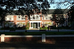
The main school building, built in 1924, is registered by Heritage New Zealand as a Category II heritage structure with registration number 1874. [3] It was originally called the West Christchurch Public School. [4] A centenary book was published in 1958.

Notable staff

Notable alumni

Related Research Articles

Christ's College, Canterbury is an independent Anglican secondary day and boarding school for boys, located in the city centre of Christchurch, New Zealand.

The 2nd New Zealand Parliament was a term of the Parliament of New Zealand. It opened on 15 April 1856, following New Zealand's 1855 election. It was dissolved on 5 November 1860 in preparation for 1860–61 election. The 2nd Parliament was the first under which New Zealand had responsible government, meaning that unlike previously, the Cabinet was chosen by Parliament rather than by the Governor-General of New Zealand.

<span class="mw-page-title-main">Canterbury Province</span> Provinces of New Zealand in South Island

The Canterbury Province was a province of New Zealand from 1853 until the abolition of provincial government in 1876. Its capital was Christchurch.

<span class="mw-page-title-main">Henry Tancred (New Zealand politician)</span> New Zealand politician

Henry John Tancred, also known as Harry Tancred, was a 19th-century New Zealand politician.

<span class="mw-page-title-main">Hagley College</span> State co-ed secondary (years 9–15) school

Hagley College, is a state secondary school in inner-city Christchurch, New Zealand. Prior to 1966 the school was Christchurch West High School, which was founded in 1858.

<span class="mw-page-title-main">Christchurch Central City</span> Central area of Christchurch, New Zealand

Christchurch Central City or Christchurch City Centre is the geographical centre and the heart of Christchurch, New Zealand. It is defined as the area within the Four Avenues and thus includes the densely built up central city, some less dense surrounding areas of residential, educational and industrial usage, and green space including Hagley Park, the Christchurch Botanic Gardens and the Barbadoes Street Cemetery.

<span class="mw-page-title-main">Christchurch East School</span> School

Christchurch East School, initially referred to as East Christchurch School, is located in the central city of Christchurch, New Zealand.

<span class="mw-page-title-main">John Anderson (mayor)</span> New Zealand blacksmith and businessman (1820–1897)

John Anderson was the second Mayor of Christchurch in New Zealand 1868–1869, and a successful businessman. He had a close connection with three buildings that have later received Category I heritage registrations by Heritage New Zealand. Two of these buildings were demolished following the February 2011 Christchurch earthquake.

<span class="mw-page-title-main">Andrew Duncan (mayor)</span> New Zealand politician (1834–1880)

Andrew Duncan was Mayor of Christchurch 1869–1870. From a working-class background in Scotland, he emigrated to New Zealand as a young man and became a highly respected member of the Christchurch community. He is remembered for his later work as an immigration agent in Scotland on behalf of the Canterbury Province.

<span class="mw-page-title-main">Edward Bishop (mayor)</span> New Zealand politician (1811–1887)

Edward Brenchley Bishop was the fourth chairman of the Christchurch Town Council, and seven years later the sixth Mayor of Christchurch in 1872–1873. Born in Maidstone, Kent to a wealthy family, his family lived in Belgium during his childhood. He took his father's profession as a distiller and worked in London for 21 years. His sister Susannah emigrated to New Zealand in 1849 and in the following year, many Bishop siblings followed her on the Charlotte Jane, one of the First Four Ships of organised settlement of Canterbury. With his brother Frederick, he had a large farm just south of Christchurch, and the suburb of Somerfield continues to use their farm's name. The brothers were spirit merchants in the city.

Daniel Reese was a 19th-century Member of Parliament from Christchurch, New Zealand.

The 3rd New Zealand Parliament was a term of the Parliament of New Zealand. Elections for this term were held between 12 December 1860 and 28 March 1861 in 43 electorates to elect 53 MPs. Two electorates were added to this during this term, Gold Fields District and a new Dunedin electorate created by splitting the existing City of Dunedin into Dunedin and Suburbs North and Dunedin and Suburbs South, increasing the number of MPs to 57. During the term of this Parliament, six Ministries were in power.

<span class="mw-page-title-main">Clarendon Tower</span> Former building in Christchurch, NZ

Clarendon Tower was a high rise building on Worcester Street at Oxford Terrace in the Christchurch Central City, New Zealand. Built on the site of the former Clarendon Hotel, the façade of the historic building was kept in the redevelopment and was protected by the New Zealand Historic Places Trust as a Category II heritage structure. Following damage from the February 2011 Christchurch earthquake, the 17-storey building has been demolished.

<span class="mw-page-title-main">John Acland (runholder)</span> New Zealand farmer and politician (1823–1904)

John Barton Arundel Acland, often referred to as J. B. A. Acland, was born in Devon, England, as the youngest child of Sir Thomas Dyke Acland, 10th Baronet. He followed his father's path of education and became a barrister in London. With his colleague and friend Charles George Tripp, he formed the plan to emigrate to Canterbury, New Zealand, to take up sheep farming. They were the first to take up land in the Canterbury high country for this purpose. When they divided their land into separate holdings, Acland kept the 100,000 acres (400 km2) that made up the Mount Peel station.

Henry Redwood was a New Zealand farmer, politician and racehorse breeder.

<span class="mw-page-title-main">Joseph Maddison</span>

Joseph Clarkson Maddison was a New Zealand architect. He trained as an architect in his native London and came to Canterbury at the age of 22. At the end of the 19th and beginning of the 20th century, he was one of the most prominent architects in Christchurch, receiving commissions from all over the country. Until the February 2011 Christchurch earthquake, 13 of his buildings were listed by Heritage New Zealand on their register, with three of those Category I listings, but many of the Christchurch buildings have been demolished since. His style was plain and utilitarian, and he specialised in the classical Italian mode.

<span class="mw-page-title-main">St Saviour's Chapel</span> Church in Lyttelton, New Zealand

St Saviour's at Holy Trinity is an Anglican church in Lyttelton, Christchurch, New Zealand. St Saviour's Chapel was relocated from West Lyttelton to Christchurch's Cathedral Grammar School in the 1970s. Following the earthquakes and the demolition of Holy Trinity Church, Lyttelton, St Saviour's was returned to Lyttelton to the site of Holy Trinity in 2013.

<span class="mw-page-title-main">Arthur Ollivier</span> New Zealand cricketer and mountaineer

Arthur Morton Ollivier was a businessman in Christchurch, New Zealand, a cricketer, mountaineer, and chess player. Mount Ollivier is named after him.

<span class="mw-page-title-main">Richard James Strachan Harman</span> New Zealand civil engineer

Richard James Strachan Harman was trained as a civil engineer. However, in Christchurch, New Zealand, he worked as a bureaucrat, politician and businessman. He was one of the Canterbury Pilgrims, having arrived in Lyttelton, on Sir George Seymour, one of the First Four Ships. He was a business partner of Edward Cephas John Stevens and senior partner of Harman and Stevens, and together they took financial control of the Christchurch newspaper The Press from its original proprietor, James FitzGerald, over a protracted period. Harman held many important roles with the Canterbury Provincial Council and was the last Deputy-Superintendent.

<span class="mw-page-title-main">Canterbury Club</span> Gentlemens Club in Christchurch, New Zealand

The Canterbury Club is a historic gentlemen's club in the central city of Christchurch, New Zealand. It was founded by urban professionals in 1872 as a breakaway club from the Christchurch Club, which had been set up by large rural landholders in 1856.

References

  1. Fricker, Gerald William (1965). "The Academy and High School of Christchurch 1858–1873". From Christchurch Academy to Hagley High School, 1858–1966 : a study of educational opportunity in New Zealand (MA). University of Canterbury. hdl:10092/4054.
  2. Fricker, Gerald William (1965). "West Christchurch School 1873–1877". From Christchurch Academy to Hagley High School, 1858–1966 : a study of educational opportunity in New Zealand (MA). University of Canterbury. hdl:10092/4054.
  3. "Christchurch West High School". New Zealand Heritage List/Rārangi Kōrero. Heritage New Zealand.
  4. Cyclopedia Company Limited (1903). "Primary Schools". The Cyclopedia of New Zealand : Canterbury Provincial District. Christchurch: The Cyclopedia of New Zealand . Retrieved 4 May 2011.
  5. McGeorge, Colin. "Thomas Scholfield Foster". Dictionary of New Zealand Biography . Ministry for Culture and Heritage . Retrieved 14 November 2012.
  6. Keey, R. B. (1974). To Him be the glory: the story of Trinity Congregational Church. Christchurch: Pegasus. p. 31.
  7. Christchurch West High School at AllBlacks.com
  8. Traue, James Edward, ed. (1978). Who's Who in New Zealand, 1978 (11th ed.). Wellington: Reed Publishing. p. 99.
  9. Grigg, A. R. "Taylor, Thomas Edward". Dictionary of New Zealand Biography . Ministry for Culture and Heritage . Retrieved 3 June 2011.
  10. Fogarty, Philippa. "Wells, Ada – Biography". Dictionary of New Zealand Biography . Ministry for Culture and Heritage . Retrieved 11 September 2011.
  11. Helms, Ruth M. "Wood, Cecil Walter". Dictionary of New Zealand Biography . Ministry for Culture and Heritage . Retrieved 30 January 2022.

43°32′15.24″S172°37′24.43″E / 43.5375667°S 172.6234528°E / -43.5375667; 172.6234528