St Peter's Church, Bryngwyn

Last updated

St Peter's Church, Bryngwyn, Monmouthshire
Church of St Peter
St Peter's Church, Bryngwyn.jpg
The entrance and tower
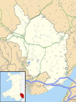
Monmouthshire UK location map.svg
Red pog.svg
St Peter's Church, Bryngwyn, Monmouthshire
Location in Monmouthshire
51°46′45″N2°53′05″W / 51.7792°N 2.8848°W / 51.7792; -2.8848
Location Bryngwyn, Monmouthshire
CountryWales
Denomination Church in Wales
History
Status parish church
FoundedC13th century
Architecture
Functional statusActive
Heritage designationGrade II*
Designated9 January 1956
Architectural type Church
Administration
Diocese Monmouth
Archdeaconry Monmouth
Deanery Raglan/Usk
Parish Bryngwyn
Clergy
Rector Rev'd Kevin Hasler

The Church of St Peter, Bryngwyn, Monmouthshire, Wales is a parish church with its origins in the 13th century. It is a Grade II* listed building.
Contents

History

Gerald of Wales records that a church at Bryngywn was built by Aeddan Gwaethfoed, the Lord of Clytha in 1180. [1] The current building dates mainly from the 15th century. [1] The church was restored in 1871 by John Prichard. [1] Throughout that time, the rector was the Reverend William Crawley, who served from 1834 to 1896, a period of 62 years. [1]

Near to the church is a well, also dedicated to St Peter, which was for many years the only water supply for the church and village. [2]

Architecture and description

The church is constructed of sandstone rubble in a Perpendicular style. [3]

Notes

  1. 1 2 3 4 Cadw. "Church of Saint Peter, Llanarth (Grade II*) (1964)". National Historic Assets of Wales . Retrieved 19 April 2022.
  2. Raglan Group of Parishes. "St Peter, Bryngwyn - Raglan Group of Parishes". Church in Wales. Retrieved 23 April 2017.
  3. Newman 2000, p. 131.

Related Research Articles

<span class="mw-page-title-main">Raglan, Monmouthshire</span> Village in Monmouthshire, Wales

Raglan (; is a village and community in Monmouthshire, south east Wales, United Kingdom. It is located some 9 miles south-west of Monmouth, midway between Monmouth and Abergavenny on the A40 road very near to the junction with the A449 road. The fame of the village derives from Raglan Castle, built for William ap Thomas and now maintained by Cadw. The community includes the villages of Llandenny and Pen-y-clawdd. Raglan itself has a population of 1,183.

<span class="mw-page-title-main">Mitchel Troy</span> Human settlement in Wales

Mitchel Troy is a village and community in Monmouthshire, south east Wales, in the United Kingdom. It is located 3 miles south west of the county town of Monmouth, just off the A40 road leading towards Raglan. Settlements within the community include Tregare, Dingestow, Cwmcarvan and Wonastow.

<span class="mw-page-title-main">Pen-y-clawdd</span> Human settlement in Wales

Pen-y-clawdd is a village in Monmouthshire, south east Wales, situated between Raglan and Monmouth. The village is the site of a medieval fortification and there is a historic church with an ancient cross in the churchyard which is a scheduled monument.

Llanfihangel Tor-y-Mynydd is a small rural village in the community of Devauden, Monmouthshire, Wales. It is located within the Vale of Usk, about 9 miles south west of Monmouth and 6 miles east of the town of Usk, between the villages of Devauden and Llansoy.

<span class="mw-page-title-main">Monmouth Priory</span> Benedictine priory in Monmouth, Wales

Monmouth Priory, in Priory Street, Monmouth, Wales, is a building that incorporates the remains of the monastic buildings attached to St Mary's Priory Church. The priory was a Benedictine foundation of 1075, and parts of the mediaeval buildings remain. The buildings were substantially redeveloped in the nineteenth century for use as St Mary's National School, and now form a community centre. The complex is a Grade II* listed building as of 27 June 1952. It is one of 24 sites on the Monmouth Heritage Trail.

<span class="mw-page-title-main">Cefntilla Court</span> House in Llandenny, Monmouthshire

Cefn Tilla Court, Llandenny, Monmouthshire, Wales, is a country house dating from the mid-19th century. Its origins date from 1616. During the English Civil War, the court was the headquarters of Thomas Fairfax during the siege of Raglan Castle and the terms of the castle's surrender were signed at the house in 1646. By the early 19th century, the court was derelict. In 1856 it was sold by Crawshay Bailey to the Memorial Committee established to commemorate the life of FitzRoy Somerset, 1st Baron Raglan, British commander during the Crimean War. The house was completely rebuilt by Thomas Henry Wyatt and donated to Lord Raglan's heir, Richard Somerset as a memorial to his father. The house is a Grade II* listed building.

<span class="mw-page-title-main">St John's Church, Llandenny</span> Church in Monmouthshire, Wales

The Church of St John is the parish church of Llandenny, Monmouthshire, Wales. It is in the Perpendicular style and is a Grade I listed building as of 27 November 1953.

<span class="mw-page-title-main">St Cadoc's Church, Raglan</span> Church in Monmouthshire, Wales

St Cadoc's Church, Raglan, Monmouthshire, south east Wales, is the parish church of the village of Raglan. The church is situated at a cross-roads in the centre of the village. Built originally by the Clare and Bluet families in the thirteenth and fourteenth centuries, it was rebuilt, and expanded by the Herbert's of Raglan Castle in the fifteenth century. In the nineteenth century, the church was subject to a major restoration by Thomas Henry Wyatt.

<span class="mw-page-title-main">Grade I listed buildings in Monmouthshire</span>

Monmouthshire is a county and principal area of Wales. It borders Torfaen and Newport to the west; Herefordshire and Gloucestershire to the east; and Powys to the north. The largest town is Abergavenny, with the other major towns being Chepstow, Monmouth, and Usk. The county is 850 km2 in extent, with a population of 95,200 as of 2020. The present county was formed under the Local Government (Wales) Act 1994, which came into effect in 1996, and comprises some sixty percent of the historic county. Between 1974 and 1996, the county was known by the ancient title of Gwent, recalling the medieval Welsh kingdom. In his essay on local government in the fifth and final volume of the Gwent County History, Robert McCloy suggests that the governance of "no county in the United Kingdom in the twentieth century was so transformed as that of Monmouthshire".

<span class="mw-page-title-main">Grade II* listed buildings in Monmouthshire</span> List of buildings in principal area of Wales

Monmouthshire is a county of Wales. It borders Torfaen and Newport to the west; Herefordshire and Gloucestershire to the east; and Powys to the north. The largest town is Abergavenny, with the other major towns being Chepstow, Monmouth, and Usk. The county is 850 km2 in extent, with a population of 95,200 as of 2020. The present county was formed under the Local Government (Wales) Act 1994, which came into effect in 1996, and comprises some sixty percent of the historic county. Between 1974 and 1996, the county was known by the ancient title of Gwent, recalling the medieval Welsh kingdom. In his essay on local government in the fifth and final volume of the Gwent County History, Robert McCloy suggests that the governance of "no county in the United Kingdom in the twentieth century was so transformed as that of Monmouthshire".

<span class="mw-page-title-main">Church of St Thomas à Becket, Wolvesnewton</span> Church in Monmouthshire, Wales

The Church of Saint Thomas à Becket in Wolvesnewton, Monmouthshire, Wales has its origins in the 13th century. Restored in the 19th century, it remains an active parish church. St Thomas's is a Grade II* listed building. The medieval churchyard cross was restored as a First World War memorial in 1920 and has its own Grade II* listing.

<span class="mw-page-title-main">St Cenedlon's Church, Rockfield</span> Church located in Monmouthshire, Wales

St Cenedlon's is a parish church in the village of Rockfield, Monmouthshire, Wales. The dedication to St Cenedlon is unusual and the history of the saint is obscure. Some sources suggest that she was a daughter of Brychan king of Brycheiniog while others identify her as the wife of King Arthfael ab Ithel, king of Glywysing. The existing church dates from the Middle Ages but only the tower remains from that period. After the English Reformation, the surrounding area of north Monmouthshire became a refuge for Catholics and Matthew Pritchard (1669-1750), Roman Catholic bishop and Vicar Apostolic of the Western District is buried at the church. By the mid-19th century the church was in ruins and a complete reconstruction was undertaken by the ecclesiastical architects John Pollard Seddon and John Prichard in around 1860. St Cenedlon's is an active parish church in the Diocese of Monmouth. It is designated by Cadw as a Grade II listed building.

<span class="mw-page-title-main">St Mary's Church, Tregare</span> Church in Monmouthshire, Wales

The Church of St Mary at Tregare, Monmouthshire, south east Wales, is the parish church of the village of Tregare. Dating originally from the fourteenth century, the tower is later, probably of the fifteenth century. The church was restored in the early twentieth century. Built in the Decorated style, the church is a Grade II* listed building.

<span class="mw-page-title-main">St Peter's Church, Llanwenarth</span> Church in Monmouthshire, Wales

The Church of St Peter, Llanwenarth, Monmouthshire is a parish church with reported origins in the 6/7th centuries. The current building dates from the early 14th century. Rebuilt in the 19th century, it was listed Grade II* in 1956. It remains an active Church in Wales church in the parish of Llanwenarth Citra.

<span class="mw-page-title-main">Church Farmhouse, Kemeys Commander</span> Farmhouse in Kemeys Commander, Monmouthshire

Church Farmhouse, Kemeys Commander, Monmouthshire is a former parsonage dating from the mid-16th century. The farmhouse and the attached barn are Grade II* listed buildings.

<span class="mw-page-title-main">St Bride's Church, Llansantffraed</span> Church in Monmouthshire, Wales

The Church of St Bride in Llansantffraed near Raglan, Monmouthshire, Wales, is a parish church of Norman origins. The church was restored by John Prichard and John Pollard Seddon in the 19th century but retains much of its earlier fabric. It is an active parish church in the parish of Llansantffraed, Monmouthshire's smallest parish, and is a Grade II* listed building.

<span class="mw-page-title-main">Llansantffraed, Monmouthshire</span> Human settlement in Wales

Llansantffraed is the smallest parish in Monmouthshire, Wales, located four miles to the west of Raglan, north of the A40 between Raglan and Abergavenny. There is no community, only the Llansantffraed Court estate and the church.

<span class="mw-page-title-main">Howick Farmhouse, Itton</span> Farmhouse in Monmouthshire, Wales

Howick Farmhouse, in the hamlet of Howick, near Itton, Monmouthshire is a farmhouse dating from the mid-16th century. It is a Grade II* listed building. Its associated barns and stable block have their own Grade II listings.

<span class="mw-page-title-main">Trivor Farmhouse, St Maughans</span> House in St Maughans, Monmouthshire

Trivor Farmhouse, St Maughans, Monmouthshire is a house dating from the late 17th century. Extended and reconstructed in the 18th century, it was originally the home of the recusant James family. In the 19th century it was bought by the Rolls family of the nearby Hendre estate. The house is Grade II* listed.

<span class="mw-page-title-main">Persondy, Mamhilad</span> House in Mamhilad, Monmouthshire

Persondy (the Priest's House), Mamhilad, Monmouthshire is a former parsonage dating from the late 16th century. It is a Grade II* listed building. The adjacent barn, now a separate residence called Ysguborwen, has its own Grade II listing.

References