The first white settlers came to the Jamberoo District during the 1820s following the initial granting of land rights, but it was not until the 1830s that the nucleus of a settlement evolved. Dr. Robert Menzies, a young Scottish naval doctor, and his wife Margaret, took up residence at Jamberoo on 6 May 1839, in a small cottage on their recently purchased property. They, in common with a number of other colonists from Scotland and from Northern Ireland, were of the Presbyterian communion. The importance they attached to their faith is illustrated by the fact that within a few months of their arrival Presbyterian services of worship were being conducted in Dr. Menzies' barn by the Rev. John Tait, MA, the first minister of the Church of Scotland in Illawarra. Mr. Tait preached from his home base in Wollongong as far south as the Shoalhaven from 1837 until his transfer to Parramatta in 1841. Dr. Menzies built "Minnamurra House" in the early 1840s, which still stands today. The barn in which the first Presbyterian service was held stood until 1940.[1]
The township of Jamberoo was subdivided from Michael Hyam's grant in 1841. Mr. Hyam, a Jew, gave blocks to some of the Churches, including the Presbyterian. In 1842 a church-school was built by the Presbyterians on their land at a cost of $70. It was made of slabs and plastered inside being constructed in the main by voluntary labour. The building was used on Sundays as church and Sunday School; other denominations used it at times. On weekdays it served as a school. It appears to have been the first Church building in the southern Illawarra.[1]
The Rev. Cunningham Atchison, who succeeded Mr. Tait in 1841, continued to minister to the whole of Illawarra and conducted services at Jamberoo as often as possible. Ministers of other denominations were also invited to conduct worship, and Dr. Menzies conducted the church services on occasions when no minister was available in Jamberoo.[1]
The Disruption of the Church of Scotland in 1843 was followed by a Disruption in the Synod of Australia. The Jamberoo and Kiama Presbyterians gave their allegiance to the Free Church party and waited for their own minister from that Church. Until their minister arrived the congregation received strong leadership from Mr. Robert Taylor, a divinity student of the Free Church of Scotland.[1]
The Rev. George Mackie, having arrived from Scotland, was inducted on 24 October 1849, at Jamberoo as Free Church minister of Leawarra and Shoalhaven, with Kiama as its centre. As the population grew, portions to the north and south were separated until the charge embraced only the districts centred upon Kiama and Jamberoo. Mr. Mackie exercised a fruitful ministry in the area until his translation to Victoria in 1857. He had resided at Jamberoo to late 1854 when he moved into the newly built Manse at Kiama.[1]
The second Minister of Kiama-Jamberoo was the Rev. John Kinross, B.A., later D.D. Newly arrived from Scotland, he was ordained and inducted into the charge on 29 December 1858, and proved to be an outstanding pastor as well as a scholar. In 1861 he married Elizabeth, one of the four daughters of Dr. Menzies. John Kinross never severed his link with the area, for, even after his translation to the office of the first Principal of St. Andrew's College, University of Sydney, in 1875, he spent the long vacations in his cottage overlooking the Jamberoo township and its people whom he loved. He retired to and died in this cottage on 16 October 1908.[1]
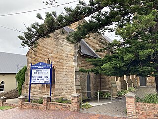
Early in the ministry of Dr. Kinross, 1862, the old Jamberoo Church was enlarged. In 1874 the congregation met and resolved to build a new and larger church to accommodate the increasing number of worshippers. John Colley, a member of one of the district's foremost pioneering families and a devout servant of the Church, drew up the plans and together with Messrs. John Marks, James Marks, D. L. Dymock, and W. Stewart superintended the construction of the present St. Stephen's which was opened and dedicated in the presence of over 1,500 people on Australia Day, 26 January 1876. The total cost was £1,060/19/1. The only debt remaining, that of £70, was cleared at the opening by a generous gift by the Messrs. Marks. The Church furnishings are made from some of the finest cedar to be seen anywhere.[1]
The original church included a wooden bell tower on top of the existing stone tower; however, this was demolished in the 1940s.[2] Following the opening of the new church the old one was repaired and incorporated in a Sunday School Hall. It was unfortunately destroyed by fire in 1972.[1]
On 5 May 1979 the Presbyterian Church of Australia nominated St Stephen's Presbyterian Church Jamberoo. A Permanent Conservation Order was placed over the Church on 6 April 1981. It was transferred to the State Heritage Register on 2 April 1999.[1]
The strength of the Presbyterian cause in Jamberoo diminished along with the population of the valley in the late twentieth century. In 1970 services of worship ceased altogether and the Church building took on a forlorn neglected appearance. It reopened in 1971 due to the efforts of the local congregation and was restored for its centenary in 1976. Funding was received from the Heritage Council in 1984 for damp-proofing and associated works.[1]
Services at the church continued until c.2001. After four years of only being used for the occasional wedding, it was listed for sale in 2005 due to mounting costs for ground maintenance and insurance.[1][3][4][5]
Local residents initially hoped to buy the building to serve as a dairy museum; however, they were unsuccessful in obtaining government funding. After some controversy around claims that there were unmarked graves on the site, subsequently dispelled after an archaeological study, it was subsequently sold to a private buyer for $580,000 in June 2009. The church stated that the proceeds would be used towards repairing the bell tower at Scots Presbyterian Church, Kiama.[6][7][2]
In 2018, the former church was operating as holiday accommodation called "The Belltower".[8]
Description
Tower
Church
St. Stephen's Church has a simple rectangular plan with a square-based tower incorporating the entry to the building at its eastern end and a small attached vestry at the western end. It construction employed coursed sandstone rubble with dressed quoining and weathering to buttresses and the tower's battlemented parapet. Openings feature simple label-moulded semi-circular heads. Internally, finishes and furniture are of local cedar. The building's substantial trussed gable-ended roof with elegant barge decoration has undergone replacement of its original shingle cladding with Marseilles tiles.[9][1]
Site
Cemetery beside the church
St. Stephen's Cemetery lies behind the church and adjacent to the Anglican and Uniting Church Cemeteries. The site is mown bare except for a small patch of crocus bulbs in the centre. A large blackberry bush which has engulfed several monuments dominates the south-west section. The stone church and large Araucaria pine trees form an appropriate back drop, which includes a small besser block amentieis block. There is no evidence of early layout.[10][1]
A cemetery on this site dates from 1859.[11] A white weatherboard house, formerly the early church is at the rear of the stone church (from a 1903 photograph). This was still extant in 1963.[12] The area to the rear of the 1876 church contains a small toilet block, the remains of an early cemetery on the site and a tree line which is set out as an indicative eastern boundary to the burials. The evident cemetery monuments are restricted to the western side of the rear allotment with both marble and sandstone stelae represented. Historical evidence from the 1860 cemetery regulations suggests that they were purposefully set out from the south and along the western boundary from an early period.[1]
The tree line eastern "boundary" of these burials runs north to south approximately 10m east of the western allotment boundary which is represented by a post and rail fence. All visible monuments of the Presbyterian cemetery are contained within the area bounded by this tree line and the western fence.[1] To the east of this tree line is an open grassed area with some faint undulations observable in the surface. The distance from the tree line to the east boundary of the allotment is approximately 20–22 metres (66–72ft).[1] Closer to the church is the area which anecdotal evidence suggests may contain unmarked children's graves. This area also shows evidence of substantial disturbance from sewer lines associated with the toilet block and septic tank.[13][1]
Situated at the western end of Jamberoo and enclosed by a timber picket fence to its Allowrie Street frontage and enclosed by a timber picket fence to its Allowrie Street frontage, St Stephen's and it grounds, which include mature camphor laurels (Cinnamomum camphora), bunya pine (Araucaria bidwillii) and Norfolk Island pines (Araucaria heterophylla) are a distinctive element of Jamberoo's townscape, prominent in the western approach to the town from Churchill Street.[9][1]
Heritage listing
Heritage boundaries
Constructed in 1875, St Stephen's Presbyterian Church Jamberoo is of significance for its reflection of the settlement, focal point and community development within the Jamberoo Valley area. St. Stephen's is associated with prominent local figures and constitutes significant milestones and consolidations in the growth of their communities. St. Stephen's is of architectural significance with its Norman-derived detailing and of landmark significance to the township of Jamberoo.[1]
The place is important in demonstrating the course, or pattern, of cultural or natural history in New South Wales.
St Stephen's is an important reflection of the settlement, focal point and community development within the Jamberoo Valley area.[1]
The place has a strong or special association with a person, or group of persons, of importance of cultural or natural history of New South Wales's history.
St. Stephen's is associated with prominent local figures and constitutes significant milestones and consolidations in the growth of their communities.[1]
The place is important in demonstrating aesthetic characteristics and/or a high degree of creative or technical achievement in New South Wales.
St. Stephen's is of architectural significance with its Norman-derived detailing and of landmark significance to the township of Jamberoo.[1]
Kiama is a coastal country town 120 kilometres south of Sydney in the Illawarra. One of the main tourist attractions is the Kiama Blowhole. Kiama features several popular surfing beaches and caravan parks, and numerous alfresco cafes and restaurants. Its proximity to the south of Sydney makes it an attractive destination for many day-trippers and weekenders. Kiama also has historically been a farming and agricultural centre. Even to today it maintains a country and agricultural community with a weekly farmers markets held on Wednesday afternoons.
The Illawarra is a coastal region in the southeast of the Australian state of New South Wales. It is situated immediately south of Sydney and north of the South Coast region. It encompasses the two cities of Wollongong, Shellharbour and the coastal town of Kiama. Wollongong is the largest city of the Illawarra with a population of 240,000, then Shellharbour with a population of 70,000 and Kiama with a population of 10,000. These three cities have their own suburbs. Wollongong stretches from Otford in the north to Windang in the south, with Maddens Plains and Cordeaux in the west.
The Southern Highlands, also locally referred to as the Highlands, is a geographical region and district in New South Wales, Australia and is 110 km south-west of Sydney. The region comprises the local government area of the Wingecarribee Shire and also towns of the Mulwaree Shire. The region is also considered a wine region.
The South Coast Railway is a commuter and goods railway line from Sydney to Wollongong and Bomaderry in New South Wales, Australia. Beginning at the Illawarra Junction, the line services the Illawarra and South Coast regions of New South Wales.
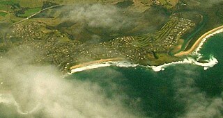
Jamberoo is a village on the South Coast of New South Wales, Australia in the Municipality of Kiama. It is approximately 11.3 km inland from Kiama. At the 2016 census, Jamberoo had a population of 1,667. The town's name is derived from an Aboriginal word meaning 'track'.
Kiama railway station is a heritage-listed intercity train station located in Kiama, New South Wales, Australia, on the South Coast railway line. The station serves NSW TrainLink diesel multiple unit trains traveling south to Bomaderry and electric multiple unit trains north to Wollongong and Sydney. Early morning and late night services to and from stations to the south are provided by train replacement bus services. It was added to the New South Wales State Heritage Register on 2 April 1999.
Oak Flats railway station is a single-platform intercity train station located in Oak Flats, New South Wales, Australia, on the South Coast railway line. The station serves NSW TrainLink trains travelling south to Kiama and north to Wollongong and Sydney. Together with the Dunmore and later Shellharbour Junction stations, Oak Flats has long served as the rail connection for the coastal suburbs of the City of Shellharbour.
Kiama is an electoral district of the Legislative Assembly in the Australian state of New South Wales. It is currently represented by Gareth Ward. Originally elected as a member of the Liberal Party, Ward stood down from the party in May 2021 following allegations of sexual misconduct.
The Illawarra Steam Navigation Company was a shipping company that serviced the south coast of New South Wales, Australia from 1858 to the early 1950s. It was formed through the amalgamation of the General Steam Navigation Company, the Kiama Steam Navigation Company and the Shoalhaven Steam Navigation Company, each of whom serviced parts of the south coast with their respective vessels. After merging, the new company held a near monopoly in regard to shipping on the south coast, and their fleet visited every significant port between Sydney and the border of Victoria. The company transported both passengers and a range of produce, including livestock, and hence it became known as the 'Pig and Whistle Line': it was said that ships would wait an hour for a pig but not a minute for a passenger.
South Coast Group 7 Rugby League is the divisional boundary drawn from the Southern Illawarra and South Coast regions of New South Wales, Australia and is governed by the NSWCRL. The main semi-professional competition,, comprises ten (10) teams from across the region. Group 7 Rugby League also administers reserve grade, third grade, and under-18s competitions, Ladies League Tag, as well as looking over many junior competitions.
Bombo is a suburb of the Municipality of Kiama, in the Illawarra region of New South Wales, Australia. It is located 2 kilometres (1.2 mi) north of Kiama.
The Municipality of Kiama is a local government area in the Illawarra region of New South Wales, Australia. The area is situated south of Shellharbour and the City of Wollongong and is located adjacent to the Pacific Ocean, the Princes Highway and the South Coast railway line.
Saddleback Mountain is a mountain near Kiama in the Illawarra region of New South Wales, Australia. The mountain rises to about 600 metres (2,000 ft) above sea level on the Illawarra escarpment and has views of Noorinan Mountain, 662 metres (2,172 ft) above sea level, and Barren Grounds Plateau to the west and south to Coolangatta Mountain and Pigeon House Mountain to Ulladulla, and north over Lake Illawarra, the Illawarra escarpment and to the Cronulla Sandhills and Kurnell Oil Refinery on a clear day.
The Minnamurra River, an open mature wave dominated barrier estuary, is located in the Illawarra region of New South Wales, Australia.
John Marks was an Australian farmer and politician. He was a member of the New South Wales Legislative Council between 1878 and 1885. He was also a member of the New South Wales Legislative Assembly for two terms from 1856 until 1859.
The 2011 Wollongong floods, beginning in March 2011, were a series of floods occurring throughout Wollongong and the Illawarra regions of New South Wales, Australia. The floods were the result of a storm cell covering most of the southern regions of the state and torrential rain in suburban Sydney and nearby regional areas.
The Jamberoo Superoos are an Australian rugby league football team based in Jamberoo, a country town of the Illawarra region. The club is a part of Country Rugby League and have competed in the South Coast first grade competition since its inception in 1914.
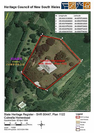
Culwalla Homestead is a heritage-listed former dairy farm and now residence located 2km east of Jamberoo Main Road, Jamberoo, Municipality of Kiama, New South Wales, Australia. It was built in 1858 by James Marks. It was added to the New South Wales State Heritage Register on 2 April 1999.
The Scots Presbyterian Church is a heritage-listed Presbyterian church at Shoalhaven Street, Kiama, Municipality of Kiama, New South Wales, Australia. It was designed by Thomas Rowe and built from 1860 to 1863 by builders Moon & Simmons and carpenters Walker Bros. It is also known as Kiama Presbyterian Church. It was added to the New South Wales State Heritage Register on 2 April 1999.
St John the Evangelist Church is a heritage-listed Presbyterian church located at Main Street, Wallerawang, City of Lithgow, New South Wales, Australia. It was designed by Edmund Blacket and Blacket and Sons, and built from 1880 to 1881 by George Donald. It is also known as the Church of St. John the Evangelist. It was added to the New South Wales State Heritage Register on 10 September 2004.
This page is based on this Wikipedia article Text is available under the CC BY-SA 4.0 license; additional terms may apply. Images, videos and audio are available under their respective licenses.