Sta. Lucia Mall

Last updated
Sta. Lucia Mall
Sta. Lucia Mall Logo.jpg
274Cainta Marikina Pasig Cities Landmarks Roads 41.jpg
2018 facade
Sta. Lucia Mall
Location Cainta, Rizal (disputed with Pasig, Metro Manila, Philippines)
Coordinates 14°37′06″N121°05′59″E / 14.6182°N 121.0998°E / 14.6182; 121.0998
Address Marcos Highway corner Felix Avenue, Barangay San Isidro, Cainta 1900 Rizal, Philippines (disputed boundary with Barangay Dela Paz, Pasig)
Opening datePhase 1: 1991;32 years ago (1991)
Phase 2 : 1993;30 years ago (1993)
Phase 3: 1998;25 years ago (1998)
il CENTRO (Phase 4): 2014;9 years ago (2014)
DeveloperSta. Lucia Realty & Development Inc.
ManagementSta. Lucia Realty & Development Inc.
OwnerExequiel D. Robles
No. of stores and services300+
Total retail floor area 240,000 m2 (2,600,000 sq ft) (2022) [1]
No. of floorsPhases 1, and 2 : 4
Phase 3 : 5
il Centro : 3
Parking1000+ slots (Grand Mall parking, iL Centro Mall car parks , and motorcycle outdoor parking)
Public transit access BSicon SUBWAY.svg Lrtalogo.svg Marikina–Pasig
Website Sta. Lucia East Grand Mall

Sta. Lucia Mall (formally Sta. Lucia East Grand Mall) is a shopping mall owned by Sta. Lucia Realty & Development Inc. It is situated at the intersection of Marcos Highway, and Felix Avenue (formerly known as Imelda Avenue), located at Barangay San Isidro, Cainta, Rizal (disputed boundary with Brgy. Dela Paz, Pasig City), Philippines, beside Robinsons Metro East.

Contents

The mall opened in 1991 as a 19,000 m2 (200,000 sq ft) shopping complex, the first in its locale. [2] As of 2014, it had a total gross floor area of 230,000 m2 (2,500,000 sq ft). [3] The mall is currently the largest shopping mall located in Rizal and Calabarzon in terms of floor area.

History

In 1991, certain of the market potentials in the east side of the metropolis and driven by the desire to diversify, Sta. Lucia East Realty and Development, Inc. (SLRDI) built Phase 1 of Sta. Lucia East Grand Mall. Two years later, in 1993, Phase II was formally opened to offer better facilities, more specialty stores, service centers, additional cinemas, a 32-lane bowling center, an entertainment arcade and a junior department store.

On May 18, 1998, Phase III was unveiled which offered bigger spaces and more comprehensive shopping and entertainment facilities. In 2005, the mall's six cinemas were renovated and it became known as the Theatre Zone. The mall was declared as a Wi-Fi zone in 2007, offering free internet access to all shoppers. [4]

In 2014, SLRDI has finished constructing the 3-level mall called iL Centro located next to the mall and is connected by a bridge offering more shops, and services. It will serve as the podium of the planned five-tower development called Sta. Lucia Residenzes. [3]

The mall is currently under redevelopment as of 2023.

Location

The mall is located beside Robinsons Metro East and situated at the busy intersection of Marcos Highway, and Felix Avenue in Cainta, Rizal (disputed boundary with Brgy. Dela Paz, Pasig City). It is highly accessible by jeepneys, buses, taxis, and even AUVs from the cities of Antipolo, Marikina, and Pasig, as well as the town itself. It is 5–10 minutes from Katipunan Avenue and Aurora Ave., a five-minute jeepney ride from Line 2 Santolan Station and directly connected to Aurora Boulevard via the highway itself. [5] It has direct access to and from LRT-2's Marikina–Pasig station.

It has been a popular place for people coming from the Eastern Metro Manila and Rizal, as all of the stores and services have been in existence even before other shopping malls were built.

Mall features

Bowling center Sta. Lucia East Grand Mall (Metro Manila; 2023-08-05) E911a 20.jpg
Bowling center

The Sta. Lucia East Grand Mall complex has 4 buildings, which are interconnected by a footbridge. The combined Phase 1 and Phase 2 of the mall has shops, services, and a supermarket located at the basement of the mall. It used to have cinemas on the third level, which are currently used for church services and masses. Home Gallery, located at the basement of the building, has a fine selection of décor, furniture and appliances.

Phase 3 has a three-level, full-line Department Store, a 7,000 square meter supermarket and a foodcourt on the lower ground floor, more upscale stores and restaurants, a 32-lane Bowling Center on the third floor, and a 10-meter high ceiling entertainment center called World of Fun along with the mall’s six cinemas on the fourth floor. [4]

Phase 4 of the mall, il Centro, is a part of Sta. Lucia Residences, a 5-tower residential condominium, where two of which have been completed. Opened in 2014, it contains more shops and services, and is accessible via bridgeway to the mall itself.

the six-story, 10,000 m2 (110,000 sq ft) Sta. Lucia Business Center, which is located next to the mall. It will have a retail space on the first and second floors, and office spaces on the rest of the floors. It will be directly connected to the Line 2 Marikina Station and to the mall itself. [6] The construction was finished by 2022

See also

Related Research Articles

<span class="mw-page-title-main">Pasig</span> Highly urbanized city in Metro Manila, Philippines

Pasig, officially the City of Pasig, is a highly urbanized city in the National Capital Region of the Philippines. According to the 2020 census, it has a population of 803,159 people.

<span class="mw-page-title-main">Marikina</span> Highly urbanized city in Metro Manila, Philippines

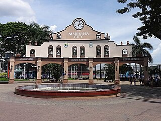
Marikina, officially the City of Marikina, is a 1st class highly urbanized city in the National Capital Region of the Philippines. According to the 2020 census, it has a population of 456,159 people.

<span class="mw-page-title-main">Antipolo</span> Capital of Rizal, Philippines

Antipolo, officially the City of Antipolo, is a 1st class component city and capital of the province of Rizal, Philippines. According to the 2020 census, it has a population of 887,399 people. It is the most populous city in the Calabarzon region, and the seventh most-populous city in the Philippines. And also, it is the most populated city under the component city status.

<span class="mw-page-title-main">San Mateo, Rizal</span> Municipality in Rizal, Philippines

San Mateo, officially the Municipality of San Mateo, is a 1st class urban municipality in the province of Rizal, Philippines. According to the 2020 census, it has a population of 273,306.

<span class="mw-page-title-main">Cainta</span> Municipality in Rizal, Philippines

Cainta, officially the Municipality of Cainta, is a 1st class urban municipality in the province of Rizal, Philippines. According to the 2020 census, it has a population of 376,933 people.

<span class="mw-page-title-main">Taytay, Rizal</span> Municipality in Rizal, Philippines

Taytay, officially the Municipality of Taytay, is a 1st class urban municipality in the province of Rizal, Philippines. It is also known as the Garments Capital of the Philippines. Most occupation of the residents are related to supplying different types of garments related things like blouses, pants, dresses and the garment itself at a very low cost. According to the 2020 census, it has a population of 386,451 people. It is the 2nd most populous municipality in the country, after Rodriguez, Rizal.

<span class="mw-page-title-main">Araneta Center–Cubao station (LRT)</span> LRT Line 2 station in Quezon City

Araneta Center–Cubao station is an elevated Manila Light Rail Transit (LRT) station situated on Line 2. The station is located in Cubao in Quezon City and is named after the old name of Araneta City, a mixed-use development.

SM City Sta. Mesa, is a shopping mall located at Magsaysay Boulevard corner Gregorio Araneta Avenue, Barangay Doña Imelda, Quezon City, Metro Manila, Philippines. It is the second SM Supermall, second in Quezon City, and the seventh SM branch developed and operated by SM Prime Holdings owned by Henry Sy, Sr. It has a land area of 3 hectares and has a gross floor area of an approximate 133,327 m2 (1,435,120 sq ft).

<span class="mw-page-title-main">Marikina–Infanta Highway</span> Scenic road in the Philippines

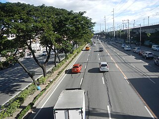
The Marikina–Infanta Highway, also known as Marilaque Highway, as well as its former name Marcos Highway, Marilaque Road or Marikina-Infanta Road, is a scenic mountain 117.5-kilometer (73.0 mi) highway that connects Metro Manila with Infanta, Quezon in the Philippines. Motorists colloquially refer to the road as Marilaque Highway.

<span class="mw-page-title-main">Ayala Malls</span> Chain of shopping malls owned by Ayala Corporation

Ayala Malls is a retail subsidiary of real estate company Ayala Land, an affiliate of Ayala Corporation. Founded in 1988, Ayala Malls own a chain of large shopping malls, all located in the Philippines. Ayala Malls is the one of the largest shopping mall retailer in the Philippines, along with SM Supermalls and Robinsons Malls.

<span class="mw-page-title-main">Ortigas Avenue</span> Major Metro Manila-Rizal arterial

Ortigas Avenue is a 12.1 km (7.5 mi) highway running from eastern Metro Manila to western Rizal in the Philippines. It is one of the busiest highways in Metro Manila, serving as the main thoroughfare of the metro's east–west corridor, catering mainly to the traffic to and from Rizal.

<span class="mw-page-title-main">SM City Marikina</span> Shopping mall in Metro Manila, Philippines

SM City Marikina is a shopping mall owned and managed by SM Prime Holdings, and is located in Calumpang, Marikina, Philippines. As part of the chain of SM Supermalls, the mall is owned by Henry Sy, Sr.

<span class="mw-page-title-main">Marikina–Pasig station</span> LRT Line 2 station in Marikina

Marikina–Pasig station is an elevated Manila Light Rail Transit (LRT) station situated on Line 2. It is located in Barangay San Roque, Marikina, near the tripoint boundary of Pasig, Metro Manila and Cainta, Rizal. The station is located on the stretch of Marikina–Infanta Highway near the intersection of Gil Fernando Avenue–Felix Avenue and is named after the cities of Marikina and Pasig which the station straddles between.

<span class="mw-page-title-main">Robinsons Metro East</span> Shopping mall in Metro Manila, Philippines

Robinsons Metro East is a shopping mall owned by Robinsons Malls. Robinsons Metro East is situated along Marcos Highway, located at Barangay Dela Paz in Pasig, Philippines. The mall opened on August 31, 2001, is currently the 3rd largest mall in the Philippines owned by Robinsons Malls.

<span class="mw-page-title-main">SM City San Mateo</span> Shopping mall in the Philippines

SM City San Mateo is a shopping mall owned by the largest mall developer in the Philippines, SM Prime Holdings. It is located along Gen. Luna Avenue, Brgy. Ampid 1, San Mateo, Rizal. This first major mall of San Mateo opens on May 15, 2015, being the fourth SM Supermall in Rizal Province after SM City Taytay, SM City Masinag and SM Center Angono, and the 52nd SM Supermall in the country. The mall is designed by JRP Design Inc., a local architectural design firm in Ayala Alabang, Muntinlupa and DSGN associates, a firm based in Dallas, Texas, United States, which also designed SM City Marikina.

<span class="mw-page-title-main">Capitol Commons</span> Mixed-use development in Pasig, Philippines

Capitol Commons is a mixed-use development in Oranbo, Pasig, Metro Manila, Philippines. It is a redevelopment of the former Rizal Provincial Capitol complex located in the village of Oranbo adjacent to the Ortigas Center financial district. The 10-hectare (25-acre) site being developed by Ortigas & Company Limited Partnership, the same developer behind Ortigas Center, features Pasig's first high-end shopping center called Estancia at Capitol Commons. Once completed, the P25-billion mixed-use commercial, residential and office development will have 35,000 square meters (380,000 sq ft) of retail space, 20,000 square metres (220,000 sq ft) of office space for knowledge process outsourcing (KPO) companies, and 280,000 square meters (3,000,000 sq ft) of residential units. The development is also home to the Capitol Commons Park, which takes up fifty percent of the development.

F.P. Felix Avenue, also called by its former name Imelda Avenue, is a four-lane major road which connects Marcos Highway to Ortigas Avenue Extension. It is one of the busiest roads in Cainta, Rizal, Philippines. The road is named after Francisco P. Felix, a former mayor of Cainta. It also serves as a boundary of Cainta and Pasig. Felix Avenue was highly accessible by jeepneys, taxis, UV express, tricycles and private vehicles.

<span class="mw-page-title-main">Araneta City Bus Port</span> Public transport terminal in Manila, Philippines

The Araneta City Bus Port (ACBP), also styled Araneta City Busport, is a bus station in Quezon City, Metro Manila, the Philippines. The bus station is currently one of two bus terminals in the Araneta City business district that link Metro Manila with the provinces in the north and south of the country, including cities in the Visayas and Mindanao via the Philippine Nautical Highway System. Built and completed in 2017 as the modern alternative to, and eventual replacement for, the adjacent Araneta City Bus Terminal, the oldest integrated bus terminal in Metro Manila, in operation since 1993, and is also a hub for buses servicing the Bicol Region. The busport is used by List of bus companies of the Philippines Within Metro Manila 9 (formerly 19) inter-city and provincial bus lines, including DLTBCo, Ceres Transport and Philtranco. The terminal is connected to the LRT Line 2 and MRT Line 3 by a network of elevated walkways and mall connections.

References

  1. "Sta. Lucia opens 4th mall at Il Centro complex". BusinessMirror. Retrieved 11 December 2016.
  2. "Sta. Lucia opens il Centro". BusinessMirror . 30 December 2014. Retrieved 16 June 2022.
  3. 1 2 "Sta Lucia Land opens extension of Cainta mall". InterAksyon.com. Archived from the original on December 24, 2016. Retrieved December 24, 2016.
  4. 1 2 "About". staluciamall.com.
  5. "Sta. Lucia opens il Centro in eastern MM". Manila Standard. Retrieved December 24, 2016.
  6. "Sta. Lucia Land forays into office development". philstar.com. Retrieved January 23, 2020.

14°37′06″N121°05′59″E / 14.6182°N 121.0998°E / 14.6182; 121.0998