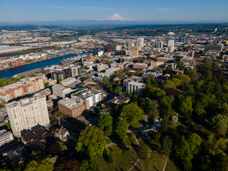
Tacoma is the county seat of Pierce County, Washington, United States. A port city, it is situated along Washington's Puget Sound, 32 miles (51 km) southwest of Seattle, 31 miles (50 km) northeast of the state capital, Olympia, and 58 miles (93 km) northwest of Mount Rainier National Park. The city's population was 219,346 at the time of the 2020 census. Tacoma is the second-largest city in the Puget Sound area and the third-largest in the state. Tacoma also serves as the center of business activity for the South Sound region, which has a population of about 1 million.
Clintonville is a suburban neighborhood in north-central Columbus, Ohio, United States with around 30,000 residents. Its borders, associated with the Clintonville Area Commission, are the Olentangy River on the west, Glen Echo Creek to the south, a set of railroad tracks to the east, and on the north by the Worthington city limits.
The Greater Richmond, Virginia area has many neighborhoods and districts.

The Rainier Valley is a district in southeast Seattle. It is located east of Beacon Hill; west of Mount Baker, Seward Park, and Leschi; south of the Central District and north of Rainier Beach. It is part of Seattle's South End.
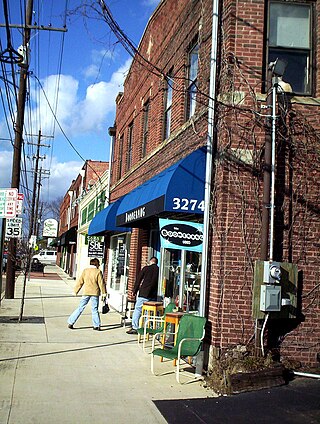
The Proctor District is a business district in the north end of Tacoma, Washington. Primarily a center for locals to shop, the District has cultivated a small town "urban village" character.

North Tacoma is a neighborhood in Tacoma, Washington, in the United States. The area is most known for waterfront parks and restaurants, Point Defiance Park, the University of Puget Sound, Stadium High School, and the Tacoma Narrows Bridge.
Old Tacoma is a neighborhood of the north end of Tacoma, Washington, more commonly known as Old Town.
Prospect Hill is a neighborhood of the north end neighborhood of Tacoma, Washington. Although Prospect Hill is considered to be the official planning name of the area, it has also gone by many other names. Locals commonly refer to it as Little Germany because of its narrow roads; it vaguely resembles a residential neighborhood that could be found somewhere in Europe. Prospect Hill is a small neighborhood with large, expensive houses. The area borders on Yakama Gulch to the west, overlooks Commencement Bay to the north, and has sweeping views of Old Tacoma to the east.
Yakima Hill is a neighborhood in the North End of Tacoma, Washington. Commonly confused with the adjacent North Slope, Yakima Hill is a distinct area. Generally, the area is defined as bordering North I Street to the south-southwest and Tacoma Avenue to the north-northeast, with another portion extending from Tacoma Avenue to the south, North Borough Road to the west, North Stadium Way to the north and northeast, and North 3rd Street to the east.
Puget Creek is a small urban creek in the U.S. state of Washington, in the north end of Tacoma, It rises in Puget Park and flows north to Commencement Bay, part of Puget Sound. Its course follows a steep ravine containing Puget Gardens Park. The creek's course is mostly contained within the 66-acre (270,000 m2) natural area of Puget Gulch. Puget Creek is the focus of restoration work by the Puget Creek Restoration Society and community volunteers. One of the restoration goals is the reestablishment of regular runs of coho and chum salmon, as well as sea-run coastal cutthroat trout.
Northeast Tacoma is a neighborhood in Tacoma, Washington. The generally accepted borders of Northeast Tacoma are the Port of Tacoma to the southwest, the unincorporated Fife Heights area to the southeast, the end of incorporated Tacoma at the Browns Point border to the northwest, and the King County border to the northeast. Its nearly 17,000 residents — roughly one in 12 Tacomans — are severed from the rest of the city by the shipyards, container cranes and grit of the Port of Tacoma.
Downtown is the central business district of Tacoma, Washington, United States, located in the inner Northeast section of the city. It is approximately bounded east-west by A Street and Tacoma Avenue, and north-south by South 7th Street and South 25th Street. The center of downtown is the intersection of 9th and Broadway.

The Hilltop Neighborhood is a historically diverse neighborhood in the Tacoma, Washington Central District.
The University District, is a 2.8-square-mile (7.3 km2) area located 2 miles (3.2 km) north of Downtown Columbus, Ohio that is home to the main campus of Ohio State University, the Battelle Institute, and Wexner Medical Center. It is generally accepted as the area bounded to the north by Clintonville at Glen Echo Ravine; to the south by the Short North at 5th Avenue; to the west by the Olentangy River and to east by the Conrail railroad tracks. Points of interest include, but are not limited to, the Ohio Stadium and Old North Columbus. The district is Columbus' most densely populated area and contains more than 650 businesses, human service agencies, churches, and schools. University District businesses include boutiques, mixed retail, several tattoo studios, the Gateway Film Center, and a diverse range of restaurants and bars.
Browns Point is a census-designated place (CDP) in Pierce County, Washington, United States, bordered by Tacoma on the east and Puget Sound on all other sides. The population was 1,198 at the 2010 census. The Tacoma neighborhood immediately adjacent to Browns Point is also referred to locally as "Browns Point".
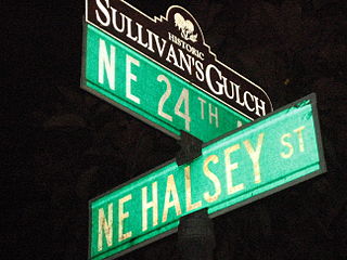
Sullivan's Gulch is a neighborhood in the Northeast section of Portland, Oregon. The name commemorates Timothy Sullivan, an early farmer in the area. Sullivan settled his donation land claim on January 27, 1851. He was born in Ireland in 1805, received citizenship in the United States in 1855, and most likely received title to the claim around 1863.
Columbus, the state capital and Ohio's largest city, has numerous neighborhoods within its city limits. Neighborhood names and boundaries are not officially defined. They may vary or change from time to time due to demographic and economic variables.

Washington Square is one of the 26 officially recognized neighborhoods of Syracuse, New York.
The McCarver Neighborhood is located in Tacoma, Washington. It is an urban neighborhood located in the Downtown and the Hilltop area of Tacoma.

Nob Hill is a neighborhood of San Francisco, California, United States that is known for its numerous luxury hotels and historic mansions. Nob Hill has historically served as a center of San Francisco's upper class. Nob Hill is among the highest-income neighborhoods in the United States, as well as one of the most desirable and expensive real estate markets in the country. Prior to Covid-19, it was the most expensive real estate market per metre squared, narrowly beating Monte Carlo, although it has since fallen heavily. It was the only place in the United States so far where market price per square metre exceeded the average yearly salary in the country.


