Stainton Beck

Last updated

Stainton Beck
St Sunday's Beck
Stainton Beck, Stainton - geograph.org.uk - 1103066.jpg
Stainton Beck framed by the Lancaster Canal aqueduct tunnel
Cumbria UK relief location map.jpg
Red pog.svg
Location of the mouth within Cumbria
Location
CountryEngland
County Cumbria
Physical characteristics
Mouth  
  location
River Bela at Milnthorpe
  coordinates
54°13′28″N2°44′27″W / 54.2245°N 2.7407°W / 54.2245; -2.7407
Length23.6 km (14.7 mi)
Stainton Beck
BSicon uexKHSTa.svg
Source of St Sunday's Beck
BSicon uexKHSTa.svg
BSicon uexSTR.svg
Source of Beehive Beck
BSicon uexRESVGa.svg
BSicon uexSTR.svg
Fisher Tarn Reservoir
BSicon uexSKRZ-Yu.svg
BSicon uexSTR.svg
bridge
BSicon uexSTR.svg
BSicon uexSKRZ-Au.svg
A684 Latterhowe Bridge
BSicon uexSKRZ-Au.svg
BSicon uexSTR.svg
A684 bridge
BSicon uexSTR.svg
BSicon uexSKRZ-Eu.svg
bridge
BSicon uexSTR.svg
BSicon uexKHSTa.svg
BSicon uexSTR.svg
Source of Strickley Beck
BSicon uexSTR.svg
BSicon uexSKRZ-Eu.svg
BSicon uexSTR.svg
bridge
BSicon uxSTRbr.svg
BSicon uexSTR.svg
BSicon uexSTR.svg
site of Gill Mill
BSicon uexSTR.svg
BSicon uexSTR.svg
BSicon uexSKRZ-Eu.svg
Millholme Bridge
BSicon uexSTR.svg
BSicon uexSTR.svg
BSicon uxSTRbr.svg
site of Millholme Mill
BSicon uexSKRZ-Eu.svg
BSicon uexSTR.svg
BSicon uexSTR.svg
bridge
BSicon uexSKRZ-Eu.svg
BSicon uexSTR.svg
BSicon uexSTR.svg
bridge
BSicon uexSKRZ-Yu.svg
BSicon uexSTR.svg
B6254 Beehive and Strickley Bridges
BSicon uexSTR.svg
BSicon uexSTR.svg
BSicon uexSKRZ-Yu.svg
B6254 St Sunday's Bridge
BSicon uexABZg+l.svg
BSicon uexSTRr.svg
BSicon uexSTR.svg
Strickley Beck
BSicon uexSTRl.svg
BSicon uexSTRq.svg
BSicon uexABZg+r.svg
Beehive Beck
BSicon uexSTRbr.svg
site of Yarn Mill, Halfpenny
BSicon uxSTRbr.svg
site of Millbridge Mill
BSicon uexSKRZ-Au.svg
A65 Mill Bridge
BSicon uexSTR+l.svg
BSicon uexSTRr.svg
Stainton Beck
BSicon uexSTRbr.svg
site of Stainton Mill
BSicon uexSKRZ-Eu.svg
Packhorse Bridge, Stainton
BSicon uexSKRZ-Eu.svg
bridge
BSicon uCONTgq.svg
BSicon uxKRZu.svg
BSicon uCONTfq.svg
Lancaster Canal Stainton Aqueduct
BSicon uexSKRZ-Eu.svg
Stainton Bridge End Bridge
BSicon uexSTR+l.svg
BSicon uexABZgr.svg
Mill race to Viver Mill
BSicon uexSTR.svg
BSicon uexABZg+l.svg
BSicon uexCONTfq.svg
Tom Beck
BSicon uexSKRZ-Au.svg
A591 bridge
BSicon uxSTRbl.svg
BSicon uexSTR.svg
Viver Mill
BSicon uexSTRl.svg
BSicon uexABZg+r.svg
Catch Water
BSicon uexSKRZ-Eu.svg
Deepthwaite Bridge
BSicon exCONTgq.svg
BSicon uexmKRZu.svg
BSicon exCONTfq.svg
former Gatebeck Tramway bridge
BSicon uexSKRZ-Yu.svg
B6385 Rowell Bridge
BSicon uexABZg+l.svg
BSicon uexCONTfq.svg
Peasey Beck
BSicon uexSTR.svg
River Bela
BSicon uexCONTf.svg
The bridge over Stainton Beck to the north of Stainton Aqueduct Stainton Beck Bridge - panoramio.jpg
The bridge over Stainton Beck to the north of Stainton Aqueduct

Stainton Beck is a watercourse in Cumbria, England. Its upper reaches are known as St. Sunday's Beck.

Contents

Course

The source of the stream is close to the 980-foot (300 m) contour on the western flank of Lambrigg Fell, near the source of Killington Beck, which is on the opposite side of the summit. It is known as St. Sunday's Beck, and flows southwards, passing through an area of woodland called Hutton Park Plantation before turning to the east. Hutton Park is on the right bank, before it turns southwards again. It is crossed by the A684 road at Latterhowe Bridge and then by a minor road. Crakehall Gill and Millrigg Gill combine before joining St Sunday's Beck on the left bank, and the stream flows to the east of the small village of New Hutton. [1]

As it approaches the hamlet of Millholme, it once powered Millholme Mill, and is crossed by Ewbank Lane at Millholme Bridge. The houses are to the south of the bridge. It turns to the west and is crossed by the B6254 road at St Sunday's Bridge, where it turns to the south-west. [1] The grade II* listed Blease Hall is located on the right bank. It dates from the early 1600s and was built for Robert Bateman. [2] Beehive Beck flows southwards from Fisher Tarn Reservoir, and joins on the left bank, as St Sunday's Beck turns to the south. It briefly turns to the west at the hamlet of Halfpenny, where there is a ford. A weir and sluices channelled water to a mill, and the A65 road crosses both the tail leat and the main channel at Mill Bridge. The road to Stainton runs along the right bank, but loops away from it at Mill Cottage and Mill House. [1]

As it approaches Stainton, its name changes to Stainton Beck. [1] A single span packhorse bridge crosses the beck. It dates from the 17th century and is built of coursed limestone rubble with rough limestone coping blocks. Between the parapets, it is 3 feet (0.9 m) wide. [3] A minor road crosses the beck just before it reaches Stainton Aqueduct, constructed by the engineer John Fletcher in 1818 for the opening of the northern section of the Lancaster Canal. The single arch is made of limestone, and has curved retaining walls. [4] The structure was badly damaged by storms in December 2015, when flood water washed away its apron, causing the canal towpath above to collapse, as well as damaging the southern portal and the wing walls. Restoration cost £2.2 million, of which £1.5 million came from the Heritage Lottery Fund. Other grants came from the Rural Payments Agency, South Lakeland District Council, Cumbria County Council and Kendal Town Council. [5] The three-year repair project was delayed by high river levels during the winters of 2018 and 2019. New concrete wing walls were built, and the stonework was repaired using as much of the original stone as possible, with some new stone where this was not possible. [6]

Just below the aqueduct, the beck is crossed by a minor road, carried by a bridge constructed in the 17th century or possibly the early 18th century. It has a single segmental arch and long sloping parapets. [7] Tom Beck joins on the left bank, the A590 road crosses, and Catch Water joins on the right bank. [1] At the hamlet of Deepthwaite, a two-arched bridge crosses the beck. Its core probably dates from the 17th century, but it was rebuilt and widened in the early 1890s. [8] The B6385 road crosses at Rowell Bridge, and on its upstream side, there was a tramway bridge, where the Gatebeck Tramway crossed on its way from Gatebeck gunpowder works on the Peasey Beck to Milnthorpe railway station. The tramway was horse-drawn, and closed in 1936. Ackenthwaite and Milnthorpe the Peasey Beck joins Stainton Beck on its left bank, with the combined flows becoming the River Bela. [1]

Beehive Beck

Beehive Beck, the main tributary of Stainton Beck, rises just below the 850-foot (260 m) contour on Hay Fell. Within a short distance, it enters Fisher Tarn Reservoir, which was built under powers contained in the Kendal Corporation Act 1894. George E Deacon was the engineer for the works, which were completed in 1896. [9] The dam is around 30 feet (9.1 m) high, and there is a central overflow section, consisting of three semi-circular sluice openings with mock medieval turrets on either side. A small machinery house is located at the foot of the overflow channel, which has a date stone showing October 1896. [10] The reservoir is still owned by United Utilities, but is no longer used for domestic water supply. [11]

Beehive Beck continues from the foot of the dam, and passes under the old Kendal to Sedbergh road. It descends quite quickly, and is then crossed by the new route between the two towns, the A684 road. [11] A minor road runs along the east bank of the stream, past Holme Park. The road crosses the beck twice before arriving at Beehive Bridge, on the B6254 road. Strickley Bridge is just a little further to the east, where Strickley Beck passes under the same road, before joining Beehive Beck on its left bank. By the time it joins Stainton Beck on its right bank, it has descended to below the 300-foot (90 m) contour. [1]

Mills

Stainton Beck has provided power to a number of mills in the past. A corn mill at Millholme was first recorded in 1310, and it was powered by a water wheel until the First World War, when a turbine was fitted to supplement the wheel. The present mill house was first occupied by the Tarn family, and carries a stone showing "J.J.T. 1734". The mill machinery was destroyed by a fire in 1927, and although the wheel and turbine were not damaged, the cost of rebuilding was beyond the means of the owner, Mr Parkin. It was converted into a house in the 1970s. [12] The mill race was on the left bank of the beck, and the corn mill was just above Millhouse Bridge. [13]

At Halfpenny, a hamlet that is part of the parish of Stainton, a weir channelled water into a race on the left bank, which fed Yarn Mill. [13] In 1849, Taylor and Company were spinning flax and tow there, as well as producing sacking. [14] A little further south, a dam across the beck created a mill pond on the right bank, from which a race fed Millbridge Mill. The tail race passed under the road, to the west of Mill Bridge, and joined the main channel further downstream. At Stainton Mill, the mill pond was part of the main channel, next to the road. The mill race continued beside the road, while the beck fell over a weir, and looped away to the west around the mill site. The tail race of the mill and the river rejoined downstream of the mill. [13] In 1849, the mill was operated by Greenwoods, who were carding wool, which was then used to produce stockings and blankets. [14] Below Stainton Bridge End Bridge, a long mill race ran across fields to the south west, to reach Viver Mill. The tail race was known as Catch Water, and rejoined the river just above Deepthwaite Bridge. [13] Viver Mill was first recorded in the 13th century as a corn mill, and remained a corn mill until 1950. [15] Although now converted to a house, the water wheel has been retained, as have some of the cruck beams and other features. [16]

Gill Mill, on Beehive Beck, was recorded in the 13th century. It was a corn mill, but was later used as a marble mill and then a sawmill. It continued in use into the 1920s. [17]

Water quality

The Environment Agency measure water quality of the river systems in England. Each is given an overall ecological status, which may be one of five levels: high, good, moderate, poor and bad. There are several components that are used to determine this, including biological status, which looks at the quantity and varieties of invertebrates, angiosperms and fish. Chemical status, which compares the concentrations of various chemicals against known safe concentrations, is rated good or fail. [18]

The water quality of the Stainton Beck system was as follows in 2019. The data covers St Sunday's Beck and Stainton Beck, as well as Beehive Beck from its source to its confluence with Stainton Beck.

SectionEcological statusChemical statusLengthCatchment
Stainton Beck Water Body [19] Moderate Fail 14.7 miles (23.7 km)11.88 square miles (30.8 km2)

Like many waterways in the UK, the chemical status changed from good to fail in 2019, due to the presence of polybrominated diphenyl ethers (PBDE) and mercury compounds, neither of which had previously been included in the assessment.

Bibliography

Related Research Articles

<span class="mw-page-title-main">Lancaster Canal</span> Canal in Northwest England

The Lancaster Canal is a canal in North West England, originally planned to run from Westhoughton in Lancashire to Kendal in south Cumbria. The section around the crossing of the River Ribble was never completed, and much of the southern end leased to the Leeds and Liverpool Canal, of which it is now generally considered part.

<span class="mw-page-title-main">Kirkby Lonsdale</span> Town and civil parish in Cumbria, England

Kirkby Lonsdale is a town and civil parish in the Westmorland and Furness district of Cumbria, England, on the River Lune. Historically in Westmorland, it lies 13 miles (21 km) south-east of Kendal on the A65. The parish recorded a population of 1,771 in the 2001 census, increasing to 1,843 at the 2011 Census.

<span class="mw-page-title-main">River Maun</span> River in Nottinghamshire, England

The River Maun is a river in Nottinghamshire, England. Its source lies in Kirkby-in-Ashfield, and from there it flows north east through Mansfield, Edwinstowe and Ollerton, these being the heart of the Sherwood Forest area. It becomes known as Whitewater near the village of Walesby and connects to the River Meden temporarily where the Robin Hood Way crosses them. They diverge, and near Markham Moor it merges again with the River Meden this time becoming the River Idle. Its main tributaries are Rainworth Water, Vicar Water and Cauldwell Water.

<span class="mw-page-title-main">River Coquet</span> River in Northumberland, England

The River Coquet runs through the county of Northumberland, England, discharging into the North Sea on the east coast at Amble. It rises in the Cheviot Hills on the border between England and Scotland, and follows a winding course across the landscape ("Coquetdale"). The upper reaches are bordered by the Otterburn Ranges military training ground, and are crossed by a number of bridges built in the 20th century. It passes a number of small villages and hamlets, and feeds one of the lakes created by extraction of gravel that form the Caistron Nature Reserve, before reaching the town of Rothbury, where it is crossed by a grade II listed bridge. Below the town is Thrum Mill, the restoration of which was featured on Channel 4 television.

<span class="mw-page-title-main">River Kent</span> River in Cumbria, England

The River Kent is a short river in the county of Cumbria in England. It originates in hills surrounding Kentmere, and flows for around 20 miles (32 km) into the north of Morecambe Bay. The upper reaches and the western bank of the estuary are located within the boundaries of the Lake District National Park. The river flows in a generally north to south direction, passing through Kentmere, Staveley, Burneside, Kendal and Sedgwick. Near Sedgwick, the river passes through a rock gorge which produces a number of low waterfalls. This section is popular with kayakers as it offers high quality whitewater for several days after rain. The village of Arnside is situated on the east bank of the Kent estuary, just above Morecambe Bay, and a tidal bore known as the Arnside Bore forms in the estuary at this point on high spring tides.

<span class="mw-page-title-main">Longsleddale</span> Valley and civil parish in Cumbria, England

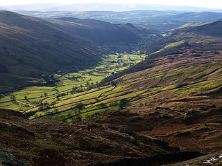
Longsleddale is a valley and civil parish in the South Lakeland district of Cumbria, England. It includes the hamlet of Sadgill. The parish has a population of 73. As the population taken at the 2011 Census was less than 100, details are maintained in the civil parish of Whitwell and Selside.

<span class="mw-page-title-main">Old Hay Brook</span> River in Sheffield, England

The Old Hay Brook is a small river in Sheffield, South Yorkshire, England. It is formed from the Redcar Brook, Blacka Dike and another stream, which rise on moors to the south of Sheffield, and is joined by Needham's Dyke near Totley Grange. At Totley Rise it joins Totley Brook, to become the River Sheaf. Water from the river was used to power mills processing lead, corn and paper from at least the 17th century, which were later used for grinding scythes as the Sheffield metal industry expanded. All the mills were defunct by 1900, although some remnants including weirs and dams are still visible.

<span class="mw-page-title-main">Peasey Beck</span> Stream in Cumbria, England

Peasey Beck is a 19.6-kilometre-long (12.2 mi) beck flowing through Cumbria, England. It rises on Lambrigg Fell where it is known as the Sparishaw Beck, flows through Killington Reservoir and converges with Stainton Beck to form the River Bela at Milnthorpe. Prior to 1913, it was known as the River Beela throughout its length.

<span class="mw-page-title-main">Little Langdale</span> Valley in the Lake District, England

Little Langdale is a valley in the Lake District, England, containing Little Langdale Tarn and a hamlet also called Little Langdale. A second tarn, Blea Tarn, is in a hanging valley between Little Langdale and the larger Great Langdale to the north. Little Langdale is flanked on the south and southwest by Wetherlam and Swirl How, and to the north and northwest by Lingmoor Fell and Pike of Blisco. The valley descends to join with Great Langdale above Elter Water.

<span class="mw-page-title-main">Eller Beck</span> River in North Yorkshire, England

The Eller Beck is a small river in North Yorkshire, England, that flows through the town of Skipton and is a tributary of the River Aire. Its channel was heavily modified to supply water to mills in the 18th and 19th centuries, and although all the mills have closed, the water now supplies power to the National Grid, generated by a turbine at High Corn Mill. The beck flows through several underground culverts in Skipton that contribute to the flood risk. To alleviate flooding in Skipton town centre, a scheme involving two flood water storage reservoirs was designed and eventually completed in 2017.

Beetham is a civil parish in the South Lakeland District of Cumbria, England. It contains 47 listed buildings that are recorded in the National Heritage List for England. Of these, four are listed at Grade I, the highest of the three grades, four are at Grade II*, the middle grade, and the others are at Grade II, the lowest grade. The parish contains the villages of Beetham, Farleton and Hazelslack, and the surrounding countryside. The Lancaster Canal passes through the parish, and the listed buildings associated with this are bridges, an aqueduct and a milestone. Most of the listed buildings in the parish are houses, some of them originally tower houses, and associated structures, farmhouses and farm buildings. The other listed buildings consist of a church, bridges, a former corn mill, milestones and a milepost, boundary stones and a boundary post, a former school, a signal box, and a war memorial.

Burton-in-Kendal is a civil parish in the South Lakeland District of Cumbria, England. It contains 32 listed buildings that are recorded in the National Heritage List for England. Of these, one is listed at Grade I, the highest of the three grades, one is at Grade II*, the middle grade, and the others are at Grade II, the lowest grade. The parish contains the village of Burton-in-Kendal and the surrounding countryside. The Lancaster Canal passes through the parish, and the listed buildings associated with this are a bridge, an aqueduct, and a milestone. The other listed buildings are located in the village, apart from two boundary stones, a milestone, and a farmhouse. In the village, the listed buildings include houses and associated structures, a church and items in the churchyard, hotels, public houses, a market cross, and a commemorative lamp post.

New Hutton is a civil parish in the South Lakeland District of Cumbria, England. It contains 12 listed buildings that are recorded in the National Heritage List for England. All the listed buildings are designated at Grade II, the lowest of the three grades, which is applied to "buildings of national importance and special interest". The parish contains the village of New Hutton, and is otherwise rural. The listed buildings include farmhouses, farm buildings, houses, one of which is used as a school, a monument, a church and associated structures, and a dam and machinery house.

Preston Patrick is a civil parish in the South Lakeland District of Cumbria, England. It contains 25 listed buildings that are recorded in the National Heritage List for England. Of these, one is listed at Grade II*, the middle of the three grades, and the others are at Grade II, the lowest grade. The parish contains the villages of Preston Patrick and Crooklands, and is otherwise mainly rural. The Lancaster Canal passes through the parish, and the listed buildings associated with it are bridges, an aqueduct, and milestones. The other listed buildings consist of houses and associated structures, farmhouses, farm buildings, boundary stones, milestones on roads, a Quaker meeting house, and a church.

Preston Richard is a civil parish in the South Lakeland District of Cumbria, England. It contains 14 listed buildings that are recorded in the National Heritage List for England. All the listed buildings are designated at Grade II, the lowest of the three grades, which is applied to "buildings of national importance and special interest". The parish contains the villages of Endmoor and Crooklands and is otherwise almost entirely rural. The Lancaster Canal runs through the parish, and the listed buildings associated with this are four bridges, an aqueduct, and a milestone. The other listed buildings consist of houses and associated structures, farmhouses, a former mill, two road milestones, and a boundary stone.

Stainton is a civil parish in the South Lakeland District of Cumbria, England. It contains eleven listed buildings that are recorded in the National Heritage List for England. All the listed buildings are designated at Grade II, the lowest of the three grades, which is applied to "buildings of national importance and special interest". The parish contains the village of Stainton, and is otherwise rural. The Lancaster Canal passes through the parish and a number of structures associated with it are listed. The other listed buildings include a farmhouse, a packhorse bridge, a church, a boundary stone, a boundary post, and a milestone.

<span class="mw-page-title-main">Oldcotes Dyke</span> River in England

Oldcotes Dyke is the name of the final section of a river system that drains parts of north Nottinghamshire and the Metropolitan Borough of Rotherham in South Yorkshire, England. Historically, it has supported milling, with seven water mills drawing their power from its water, and ran through the grounds of the Cistercian Roche Abbey. It is a tributary of the River Ryton.

<span class="mw-page-title-main">Halfpenny, Cumbria</span> Hamlet in England

Halfpenny is a hamlet in the civil parish of Stainton, in the South Lakeland district, in the county of Cumbria, England. It is located roughly two and a half miles south east of Kendal. There is notably a ford over St Sunday's Beck, a tributary to the River Bela. Until sometime in the 20th century, there was also a watermill – Halfpenny Mill – in the village, which was by the mid-19th century producing flax, and then coconut matting, paper, and sweet manufacture. Halfpenny is accessible off of the A65.

References

  1. 1 2 3 4 5 6 7 Ordnance Survey, 1:25,000 map
  2. Historic England. "Blease Hall (1312207)". National Heritage List for England .
  3. Historic England. "Pack Horse Bridge at the Post Office (1007138)". National Heritage List for England .
  4. Historic England. "Stainton Aqueduct (1086532)". National Heritage List for England . Retrieved 28 September 2021.
  5. Nicholson 2020.
  6. "Stainton Aqueduct, Lancaster Canal". Canal and River Trust. 21 October 2020. Archived from the original on 5 August 2021.
  7. Historic England. "Stainton Bridge over Stainton Beck (1086534)". National Heritage List for England .
  8. Historic England. "Deepthwaite Bridge over Stainton Beck (1086553)". National Heritage List for England .
  9. "Fisher Tarn Dam, New Hutton, Cumbria". Historic England. Archived from the original on 1 October 2022.
  10. Historic England. "Dam and machinery house at Fisher Tarn Reservoir (1087288)". National Heritage List for England .
  11. 1 2 "Fisher Tarn, Kendal". Waymarking.com. Archived from the original on 1 October 2022.
  12. "Millholme Mill" (PDF). Fine & Country. Archived (PDF) from the original on 1 October 2022.
  13. 1 2 3 4 Ordnance Survey, 6 inch map, 1888-1913
  14. 1 2 Mannex 1849, p. 280.
  15. "Viver Watermill bed and breakfast". BedandBreakfast.uk. Archived from the original on 10 October 2022.
  16. "Viver Mill" (PDF). Fine and Country. Archived (PDF) from the original on 10 October 2022.
  17. "Gill Mill, New Hutton". Old Cumbria Gazetteer. Archived from the original on 1 October 2022.
  18. "Glossary (see Biological quality element; Chemical status; and Ecological status)". Catchment Data Explorer. Environment Agency. Retrieved 17 May 2017.
  19. "Stainton Beck Water Body". Catchment Data Explorer. Environment Agency.