Stanton County is a county in the U.S. state of Nebraska. As of the 2020 United States Census, the population was 5,842. Its county seat is Stanton. The county was formed in 1856 and organized in 1867. It was first called Izard County until 1862, when it was renamed for Edwin M. Stanton, Secretary of War during the administration of President Abraham Lincoln.

Stevens County is a county located in the U.S. state of Kansas. Its county seat is Hugoton. As of the 2020 census, the county population was 5,250. The county is named for Thaddeus Stevens, a Reconstruction era Pennsylvania politician.

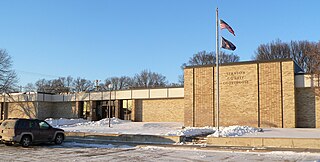
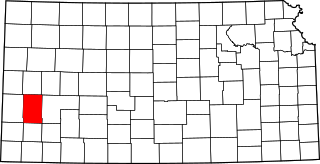
Stanton County is a county located in the U.S. state of Kansas. Its county seat is Johnson City. As of the 2020 census, the county population was 2,084. It was named for Edwin Stanton, the U.S. Secretary of War during most of the American Civil War.

Miami County is a county located in east-central Kansas and is part of the Kansas City metropolitan area. Its county seat and most populous city is Paola. As of the 2020 census, the county population was 34,191. The county was named for the Miami tribe.

Linn County is a county in the U.S. state of Kansas, located in along the eastern edge of Kansas, and is part of the Kansas City metropolitan area. Its county seat is Mound City, and its most populous city is Pleasanton. As of the 2020 census, the county population was 9,591. The county was named for Lewis Linn, a U.S. Senator from Missouri.
Kearny County is a county located in the U.S. state of Kansas. Its county seat and most populous city is Lakin. As of the 2020 census, the county population was 3,983. The county is named in honor of Philip Kearny, a general during the American Civil War that died during the Battle of Chantilly.

Johnson County is a county in the U.S. state of Kansas, along the border of the state of Missouri. Its county seat is Olathe. As of the 2020 census, the population was 609,863, the most populous county in Kansas. The county was named after Thomas Johnson, a Methodist missionary who was one of the state's first settlers. Largely suburban, the county contains a number of suburbs of Kansas City, Missouri, including Overland Park, a principal city of and second most populous city in the Kansas City Metropolitan Area.

Grant County is a county located in the U.S. state of Kansas. Its county seat and only city is Ulysses. As of the 2020 census, the county population was 7,352. Both the county and its seat are named after Ulysses Grant, the 18th President of the United States.

Paola is a city in and the county seat of Miami County, Kansas, United States. As of the 2020 census, the population of the city was 5,768.

Johnson City is a city in and the county seat of Stanton County, Kansas, United States. As of the 2020 census, the population of the city was 1,464.
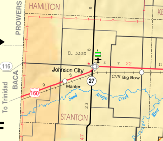
Big Bow is an unincorporated community in Stanton County, Kansas, United States. As of the 2020 census, the population of the community and nearby areas was 32.

Fred Schuyler Jackson was a U.S. Representative from Kansas.

K-27 is an approximately 226-mile-long (364 km) north–south state highway that parallels Kansas' western border with Colorado. It is the westernmost north–south state highway in the state. It begins at U.S. Route 56 (US-56) in Elkhart near the Oklahoma state line and travels through the seven counties that border Colorado until reaching its northern terminus north of St. Francis, where it ends at the Nebraska state line. Along the way, it intersects several major highways, including US-160 in Johnson City, US-50 and US-400 in Syracuse, US-40 in Sharon Springs, Interstate 70 (I-70) and US-24 in Goodland, and US-36 in Wheeler. The section from US-40 north to Nebraska, is designated as the Land and Sky Scenic Byway. K-27 changes time zones twice, during its trek through Kansas, the only highway in the state to do so.
Stanton Township may refer to:

This is a list of the National Register of Historic Places listings in Miami County, Kansas.

Bucyrus is an unincorporated community in Miami County, Kansas, United States. As of the 2020 census, the population of the community and nearby areas was 171. It is located 6 miles (9.7 km) east-southeast of Spring Hill, and named after Bucyrus, Ohio. It is part of the Kansas City metropolitan area.
Hillsdale is an unincorporated community in Miami County, Kansas, United States. As of the 2020 census, the population of the community and nearby areas was 247. Hillsdale is located near U.S. Route 169 and K-7 6 miles (9.7 km) north-northeast of Paola. It is part of the Kansas City metropolitan area.
Jingo is an unincorporated community in Miami County, Kansas, United States. It is part of the Kansas City metropolitan area.

New Lancaster is an unincorporated community in Miami County, Kansas, United States. It is part of the Kansas City metropolitan area.
Wagstaff is an unincorporated community in Miami County, Kansas, United States. It is part of the Kansas City metropolitan area.


