
Albert Bridge is a heritage-listed railway bridge of steel truss design crossing the Brisbane River between Indooroopilly and Chelmer in the City of Brisbane, Queensland, Australia. It was designed by Henry Charles Stanley and built from 1894 to 1895 by John McCormick & Son as a replacement for an earlier bridge lost to flooding in 1893. Both bridges were named in honour of the Prince of Wales, Prince Albert. It was added to the Queensland Heritage Register on 21 October 1992.

An arch bridge is a bridge with abutments at each end shaped as a curved arch. Arch bridges work by transferring the weight of the bridge and its loads partially into a horizontal thrust restrained by the abutments at either side, and partially into a vertical load on the arch supports. A viaduct may be made from a series of arches, although other more economical structures are typically used today.

A clapper bridge is an ancient form of bridge found on the moors of the English West Country and in other upland areas of the United Kingdom including Snowdonia and Anglesey, Cumbria, Derbyshire, Yorkshire, Lancashire, and in northern Wester Ross and north-west Sutherland in Scotland. It is formed by large flat slabs of stone, often granite or schist. These can be supported on stone piers across rivers, or rest on the banks of streams.

Tarr Steps is a clapper bridge across the River Barle in the Exmoor National Park, Somerset, England. The bridge is in a national nature reserve about 2.5 miles (4 km) south east of Withypool and 4 miles (6 km) north west of Dulverton.

The Store Street Aqueduct in central Manchester, England, was built in 1798 by Benjamin Outram on the Ashton Canal. A Grade II* listed building, it is built on a skew of 40° across Store Street, and is believed to be the first major aqueduct of its kind in Great Britain and the oldest still in use today.
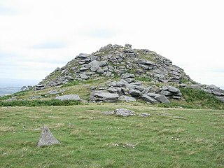
Linkinhorne is a civil parish and village in southeast Cornwall, England, United Kingdom. The village itself is situated at grid reference SX 320 736 and is approximately four miles (6.5 km) northwest of Callington and seven miles (11 km) south of Launceston. The parish population at the 2011 census including Downgate was 1,541

The Hares Hill Road Bridge is a single-span, wrought iron, bowstring-shaped lattice girder bridge. It was built in 1869 by Moseley Iron Bridge and Roof Company and is the only known surviving example of this kind. The bridge spans French Creek, a Pennsylvania Scenic River.
Chesters Bridge was a Roman bridge over the River North Tyne at Chollerford, Northumberland, England, and adjacent to the Roman fort of Cilurnum on Hadrian's Wall. The fort, mentioned in the Notitia Dignitatum, and now identified with the fort found at Chesters, was known as Cilurnum or Cilurvum.

The Peats Ferry Bridge is a steel truss bridge that carries the Pacific Highway (B83) across the Hawkesbury River, between Kangaroo Point and Mooney Mooney Point, located 40 kilometres (25 mi) north of Sydney in New South Wales, Australia. The bridge carries the Hornsby to Kariong section of highway, while the adjacent Brooklyn Bridge carries the Pacific Motorway (M1).

The River Irwell Railway Bridge was built for the Liverpool & Manchester Railway (L&MR), the world's first passenger railway which used only steam locomotives and operated as a scheduled service, near Water Street in Manchester, England. The stone railway bridge, built in 1830 by George Stephenson, was part of Liverpool Road railway station. The bridge was designated a Grade I listed building on 19 June 1988.

Rillaton is a hamlet in the parish of Linkinhorne in Cornwall, England. Nearby is the Bronze Age round barrow where the Rillaton Gold Cup was found in 1837.

The Yair Bridge or Fairnilee Bridge is a bridge across the River Tweed at Yair, near Galashiels in the Scottish Borders.

The A3071 is a minor 'A' road in the English county of Cornwall, which links St Just to Penzance and the A30. It is 6.2 miles long.

Clackline Bridge is a road bridge in Clackline, Western Australia, 77 kilometres (48 mi) east of Perth in the Shire of Northam, that carried the Great Eastern Highway until 2008. It is the only bridge in Western Australia to have spanned both a waterway and railway, the Clackline Brook and the former Eastern Railway alignment. The mainly timber bridge has a unique curved and sloped design, due to the difficult topography and the route of the former railway. The bridge was designed in 1934 to replace two dangerous rail crossings and a rudimentary water crossing. Construction began in January 1935, and was completed relatively quickly, with the opening ceremony held in August 1935. The bridge has undergone various improvement and maintenance works since then, including widening by three metres (10 ft) in 1959–60, but remained a safety hazard, with increasing severity and numbers of accidents through the 1970s and 1980s. Planning for a highway bypass of Clackline and the Clackline Bridge began in the 1990s, and it was constructed between January 2007 and February 2008. The local community had been concerned that the historic bridge would be lost, but it remains in use as part of the local road network, and has been listed on both the Northam Municipal Heritage Inventory and the Heritage Council of Western Australia's Register of Heritage Places.

Bremer River Rail Bridge is a heritage-listed railway bridge at off Bremer Street, North Ipswich, City of Ipswich, Queensland, Australia. It was built from 1865 to 1915. It was added to the Queensland Heritage Register on 11 December 2006.
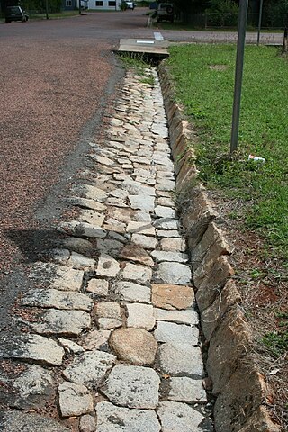
The Stone kerbing, channels and footbridges of Charters Towers is a heritage-listed group of water infrastructure at various locations in Charters Towers City, Millchester, Queenton, and Richmond Hill throughout Charters Towers, Charters Towers Region, Queensland, Australia. It was built from c. 1884 to 1930s. It was added to the Queensland Heritage Register on 7 February 2005.
Stara Woods is a privately owned woodland in East Cornwall, England, UK, of local interest after being bought by a local resident in 2004 and repurposed as a community woodland. The woods are in the Lynher Valley and south-southeast of North Hill.

St Peter's Bridge carries the A5189 road across the River Trent in Burton upon Trent, Staffordshire, England. Opened in 1985, the 800-metre (2,600 ft) long reinforced concrete bridge is the most recent road crossing of the Trent. It was closed for more than two months in 2017 for major repair works.

Monks Bridge is a road bridge across the River Dove between Stretton, Staffordshire, and Egginton, Derbyshire. A bridge has existed here since the early 13th century, though much of the current structure dates to the 15th century. It formerly carried traffic on what is now the A38 road but a replacement structure was built to the north in 1926. It was formerly used as a slip road but is now out of use to vehicular traffic.
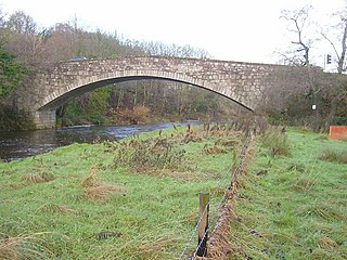
Buittle Bridge, also known as Craignair Bridge is a bridge over the Urr Water just outside Dalbeattie in Dumfries and Galloway, Scotland. Completed in 1797, it replaced and earlier two-span bridge of the same name which was destroyed in a flood a short time after its completion; the remains of this older bridge, comprising the base of its pier and some remnants of its south-west abutment, survive a short distance upstream.
