Related Research Articles

The Tamar is a river in south west England that forms most of the border between Devon and Cornwall. A large part of the valley of the Tamar is protected as the Tamar Valley National Landscape, and some is included in the Cornwall and West Devon Mining Landscape due to its historic mining activities.

The River Camel is a river in Cornwall, England. It rises on the edge of Bodmin Moor and with its tributaries its catchment area covers much of North Cornwall. The river flows into the eastern Celtic Sea between Stepper Point and Pentire Point having covered about 30 miles (50 km) making it the second longest river wholly in Cornwall. The river is tidal upstream to Egloshayle and is popular for sailing, birdwatching and fishing. The name Camel comes from the Cornish language for 'the crooked one', a reference to its winding course. Historically the river was divided into three named stretches. Heyl was the name for the estuary up to Egloshayle, the River Allen was the stretch between Egloshayle and Trecarne, whilst the Camel was reserved for the stretch of river between its source and Trecarne.

A clapper bridge is an ancient form of bridge found on the moors of the English West Country and in other upland areas of the United Kingdom including Snowdonia and Anglesey, Cumbria, Derbyshire, Yorkshire, Lancashire, and in northern Wester Ross and north-west Sutherland in Scotland. It is formed by large flat slabs of stone, often granite or schist. These can be supported on stone piers across rivers, or rest on the banks of streams.

The North Downs are a ridge of chalk hills in south east England that stretch from Farnham in Surrey to the White Cliffs of Dover in Kent. Much of the North Downs comprises two Areas of Outstanding Natural Beauty (AONBs): the Surrey Hills and the Kent Downs. The North Downs Way National Trail runs along the North Downs from Farnham to Dover.

Long Ashton is a village and civil parish in Somerset, England. It falls within the unitary authority of North Somerset and is one of a number of large villages just outside the boundary of city of Bristol urban area. The parish has a population of 6,044. The parish includes the hamlet of Yanley, and the residential area of Leigh Woods.
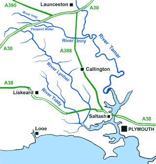
The River Lynher flows through east Cornwall, England, and enters the River Tamar at the Hamoaze, which in turn flows into Plymouth Sound.

Calstock is a civil parish and a large village in south east Cornwall, England, United Kingdom, on the border with Devon. The village is situated on the River Tamar 6 miles (9.7 km) south west of Tavistock and 10 miles (16 km) north of Plymouth.

St Mabyn is a civil parish and village in Cornwall, England, United Kingdom. The village is situated three miles (5 km) east of Wadebridge. The parish includes a hamlet called Longstone to the east and many small manor houses, including Tregarden, Tredethy, Helligan Barton and Colquite, all built in the 16th and 17th centuries. The area of the parish is 4,101 acres (16.60 km2).

North Tawton is a small town in Devon, England, situated on the river Taw. It is administered by West Devon Council. The population of the electoral ward at the census 2011 was 2,026.

Tempsford is a village and civil parish in the Central Bedfordshire district of the county of Bedfordshire, England, about 7 miles (11 km) east north-east of the county town of Bedford.
Linkinhorne is a civil parish and village in southeast Cornwall, England, United Kingdom. The village itself is situated at grid reference SX 320 736 and is approximately four miles (6.5 km) northwest of Callington and seven miles (11 km) south of Launceston. The parish population at the 2011 census including Downgate was 1,541

Thackley is a small suburb near Bradford, West Yorkshire in England. The village is loosely bordered by the village of Idle to the south, to the west by the West Royd area of Shipley and elsewhere by the Leeds and Liverpool Canal. Thackley is the northernmost part of Bradford south of the River Aire.

Gribbin Head is a promontory on the south coast of Cornwall, England, UK, owned and managed by the National Trust. It separates St Austell Bay from the estuary of the River Fowey and is marked by a large tower used to aid navigation of ships approaching the local harbours. The nearest town is Fowey. The western point of the headland is called Little Gribbin.

Dizzard is an area, in the civil parish of St Gennys, Cornwall, containing five farms. On the coast is Dizzard Point, and the unique, dwarf oak, Dizzard Wood, which is of international importance for its lichen communities.

Sharptor is a hamlet west of Henwood in the civil parish of Linkinhorne in east Cornwall, England, United Kingdom. It is named after Sharp Tor on Bodmin Moor. Sharptor is close to Minions to the south, Kingbeare in the north and Darleyford to the east. Sharptor is around 280 metres (920 ft) above sea level.

The Lebanon Valley Rail Trail (LVRT) is a National Recreation Trail. The rail trail goes from the southwestern border of Lebanon County and goes through Colebrook, Mt. Gretna, Cornwall, and the city of Lebanon. At the southern border of Lebanon County, Pennsylvania the LVRT connects with the Conewago Recreation Trail and continues for another 5.0 miles (8.0 km). The trail is partly built on the old Cornwall–Lebanon Railroad created by industrialist Robert H. Coleman in the 1880s. The trail runs 15.0 miles (24.1 km), and there are many phases in development that would extend the trail to northern Lebanon County and Jonestown. The trail features a packed stone path and paved path at many parts that traverses "Pennsylvania Dutch Country" and other scenic routes. Trail users see untouched woodlands of state gamelands, forests, and views of area fields and farms. The trail is maintained by dedicated group of volunteers, and allows for running, walking, biking, horseback riding, and cross-country skiing.
Broadclough – historically Broad Clough – is a village located to the north of Bacup, previously having been a part of the old borough of Bacup and now with Rossendale borough of Lancashire and part of the Greenclough Ward. It is part of the Rossendale and Darwen constituency, with Jake Berry having been the Member of Parliament since 2010. Like much of Bacup, Broadclough is rapidly becoming a commuter area for cities and towns such as Manchester, Burnley, Accrington, Preston, Blackburn, Rochdale.
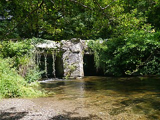
Stara Bridge is a clapper bridge across the River Lynher in east Cornwall, England, dating to the Late Middle Ages and now scheduled under the Ancient Monuments and Archaeological Areas Act 1979 as a rare surviving example of such bridge types. The surrounding area is known as Starabridge.

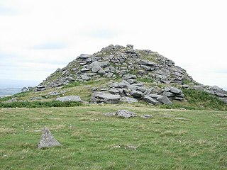
Largin Castle is a contour hillfort and scheduled monument in Cornwall, England, presumed to date from the Iron Age.
Nance Wood is a woodland Site of Special Scientific Interest (SSSI) near Portreath, west Cornwall. The site was first notified in 1951 for its almost pure dwarf, sessile oak coppiced woodland, good bryophyte flora and Irish spurge, which is found in only two localities in Britain.
References
- 1 2 Fergusson, Kirsty (2015). Cornwall (Slow Travel). Bradt Travel Guides. pp. 99–100. ISBN 9781841628646.
- 1 2 3 "New South East Cornwall bridge opens up community woodland". Western Morning News. 27 February 2013.
- ↑ "Magic Map". Defra, Ordnance Survey.
- 1 2 "Stara Community Woodland - A Cornish woodland protected for all". Friends of Stara Wood.