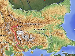
The Struma or Strymónas is a river in Bulgaria and Greece. Its ancient name was Strymṓn. Its drainage area is 17,330 km2 (6,690 sq mi), of which 10,797 km2 (4,169 sq mi) in Bulgaria, 6,295 km2 (2,431 sq mi) in Greece and the rest in the Republic of Macedonia. It takes its source from the Vitosha Mountain in Bulgaria, runs first westward, then southward, forming a number of gorges, enters Greek territory at the Kula village. In Greece it is the main waterway feeding and exiting from Lake Kerkini, a significant centre for migratory wildfowl. The river flows into the Strymonian Gulf in Aegean Sea, near Amphipolis in the Serres regional unit. The river's length is 415 kilometres.

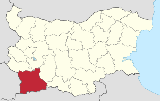
Simitli also known as Simitliya, is a town in Blagoevgrad Province in southwestern Bulgaria. It has a population of 7,454 and is located 17 km south of Blagoevgrad. It is the seat of Simitli Municipality.
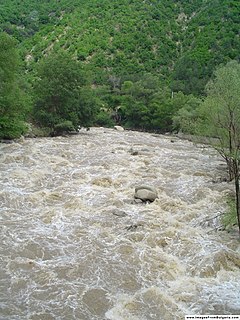
Kresna Gorge is a steep valley in south-western Bulgaria, stretching about 18 km. The gorge has been formed by the Struma River, which flows from the Vitosha mountains. Kresna gorge has a rich biodiversity, which has come under pressure from the Struma motorway construction project, a new leg of the Trans European Corridor No. 4. In the south, the gorge bisects the Tisata nature reserve.

The Kresna–Razlog Uprising was a Bulgarian uprising against the Ottoman rule, predominantly in the areas of Kresna and Razlog in late 1878 and early 1879. It broke out following the protests and spontaneous opposition to the decisions of the Congress of Berlin, which, instead of ceding the Bulgarian-populated parts of Macedonia to the newly reestablished Bulgarian suzerain state per the Treaty of San Stefano, returned them to Ottoman control. It was prepared by the "Edinstvo" Committee.

Gostun is a village (село) in southwestern Bulgaria, located in the Bansko Municipality of the Blagoevgrad Province. It is located on the eastern slopes of the Rhodope Mountains, east of Mesta river 17 kilometers southeast of Bansko, 54 kilometers southeast of Blagoevgrad and 103 kilometers southeast of Sofia.
Koprivlen is a village in Hadzhidimovo Municipality, in Blagoevgrad Province, Bulgaria.
Dolna Gradeshnitsa is a village in Kresna Municipality, in Blagoevgrad Province, Bulgaria.
Gorna Breznitsa is a village in Kresna Municipality, in Blagoevgrad Province, Bulgaria.
Oshtava is a village in Kresna Municipality, in Blagoevgrad Province, Bulgaria.
Slivnitsa (village) is a village in Kresna Municipality, in Blagoevgrad Province, Bulgaria.
Vlahi (village) is a village in Kresna Municipality, in Blagoevgrad Province, Bulgaria.

Bogoroditsa is a village in Petrich Municipality, in Blagoevgrad Province, Bulgaria.
Brezhani is a village in Simitli Municipality, in Blagoevgrad Province, in southwestern Bulgaria.
Krupnik (Крупник) is a village in Simitli Municipality, in Blagoevgrad Province, in southwestern Bulgaria in the Kresna Gorge.It is located at the western part of Maleshevskata mountain.
Poleto is a village in Simitli Municipality, in Blagoevgrad Province, in southwestern Bulgaria.
Chervena skala is a village in Ardino Municipality, Kardzhali Province, southern-central Bulgaria. It covers an area of 2.195 square kilometres and as of 2007 had a population of 87 people.
Strazhnitsa is a village in Chernoochene Municipality, in Kardzhali Province, in southern-central Bulgaria. It covers an area of 2.155 square kilometres and as of 2007 it had a population of 183 people.
Ezerets is a village in Kresna Municipality, Blagoevgrad Province, Bulgaria.