Kresna Gorge

Last updated • 3 min readFrom Wikipedia, The Free Encyclopedia
Kresna Gorge
Кресненско дефиле
Struma-at-kresna-imagesofbulgaria.jpg
Struma River in Kresna Gorge
Relief Map of Bulgaria.jpg
Red pog.svg
Kresna Gorge
Location within Bulgaria
Floor elevation222 m (728 ft)
Length18 km (11 mi)north to south
Geology
Type Gorge
Geography
Location Pirin and Maleshevo mountain ranges, Bulgaria
Coordinates 41°46′7″N23°9′18″E / 41.76861°N 23.15500°E / 41.76861; 23.15500

Kresna Gorge (Bulgarian : Кресненско дефиле) is a steep valley in south-western Bulgaria, stretching about 18 km (11 mi). The gorge has been formed by the Struma River, which flows from the Vitosha mountains. Kresna gorge has a rich biodiversity, which has come under pressure from the Struma motorway construction project, a new leg of the Trans European Corridor No. 4. [1] [2] In the south, the gorge bisects the Tisata nature reserve.

Contents

Kresna Gorge was the place of the Battle of Kresna Gorge between Bulgaria and Greece during the 1913 Second Balkan War. The Greek army was threatened by encirclement in the valley, but due to the Romanian army advancing against the undefended capital Sofia, Bulgaria had to agree to an armistice and the resulting peace treaty in Bucharest which was unfavorable to Bulgaria's territorial aspirations. [3]

Terrain and Climate

Tisata Reserve protects the Mediterranean evergeen flora of the Kresna Gorge, including Bulgaria's largest habitats of Greek juniper and green olive tree Greek juniper in Tisata Reserve, Bulgaria.jpg
Tisata Reserve protects the Mediterranean evergeen flora of the Kresna Gorge, including Bulgaria's largest habitats of Greek juniper and green olive tree

Kresna Gorge is situated near the villages of Palat, Drakata, and Krupnik while surrounded by the Pirin and Maleshevska Mountains. The gorge is a transitory Mediterranean climate, as it is located between the Central-European and Mediterranean climate zones. The Struma River cuts through the gorge and is a main geological feature. Near the riverbank are sediment soils which transition into shallow alluvial soil with maroon soil on the side. [4] The rocky terrain varies throughout the gorge, including stony slopes, large vertical cliffs, and small rocky sections.

Ecology

Kresna Gorge is home to a diverse fauna and flora, as well as a ranging terrain.[ further explanation needed ] The southern reaches of the gorge bisect the Tisata nature reserve in two. The gorge is home to many important Mediterranean plant species, habitats, landscapes, and bird wildlife. [5] There are approximately 31 species of reptiles, 75 species of mammals, and 232 species of birds in this relatively small gorge. [6] Kresna Gorge is considered a Natura 2000 conservation site, signifying its importance in the protection of endangered species. Some species of birds, such as cormorants, may not nest and breed in the gorge, but are utilizing its resources as part of longer passageways and migratory routes. The resources provided by the gorge are crucial, and serve as the main resting sites to threatened and rare species such as the Egyptian vulture. [7]

There are multiple types of forests located inside the gorge, including different types of oak trees such as Quercus pubescens , Carpinus orientalis , and Fraxinus ornus . Considering the climate, typical Mediterranean flora species such as Quercus coccifera and Phillyrea thrive here. [6] The magnitude of the vegetation and plant population in Kresna provides a foundation for the varied populations of birds and other animals who lives here.

Struma Motorway

The Struma motorway, a project that is part of The European Transport Corridor No IV, is planned to cut through the Kresna Gorge. The motorway is seen by the European Union, as well as the Bulgarian government, as a vital trade and tourism route, and receives funding from the European Investment Bank (EIB). [8] The motorway will provide a passageway from Germany and Hungary to Greece, and aims to boost the Bulgarian economy. The project, however, will also have some destructive effects for the inhabitants of the gorge and its ecosystem. With the current road in the gorge, lack of proper mitigation has already led to many road kills over the years; with the construction of the new motorway project, animal mortality rate is expected to increase, not just because of direct traffic accidents but also because of the effects of deforestation and habitat loss. [9]

The locals in the nearby villages are afraid their shops and livelihoods will be deserted when the motorway opens. They also fear that Kresna will attract fewer tourists and that young residents will migrate to other countries. [10] The motorway will force some of the villagers to lose land and property during the construction, negatively impacting their livelihoods. [10]

The European Union financed both the Bulgarian government to build the motorway and the environmental groups that defend the endangered nature through construction. There has been a long battle between the government and construction companies on the one hand and residents and environmental groups on the other. [11]

Related Research Articles

<span class="mw-page-title-main">Geography of Bulgaria</span>

Bulgaria is a country situated in Southeast Europe that occupies the eastern quarter of the Balkan peninsula, being the largest country within its geographic boundaries. It borders Romania to the north, Serbia and North Macedonia to the west, Greece and Turkey to the south, and the Black Sea to the east. The northern border with Romania follows the river Danube until the city of Silistra. The land area of Bulgaria is 110,994 square kilometres (42,855 sq mi), slightly larger than that of Cuba, Iceland or the U.S. state of Tennessee. Considering its relatively compact territorial size and shape, Bulgaria has a great variety of topographical features. Even within small parts of the country, the land may be divided into plains, plateaus, hills, mountains, basins, gorges, and deep river valleys. The geographic center of Bulgaria is located in Uzana.

<span class="mw-page-title-main">Struma (river)</span> River in Bulgaria and Greece

The Struma or Strymónas is a river in Bulgaria and Greece. Its ancient name was Strymṓn. Its drainage area is 17,330 km2 (6,690 sq mi), of which 8,670 km2 (3,350 sq mi) in Bulgaria, 6,295 km2 (2,431 sq mi) in Greece and the remaining 2,365 km2 (913 sq mi) in North Macedonia and Serbia. It takes its source from the Vitosha Mountain in Bulgaria, runs first westward, then southward, forming a number of gorges, enters Greece near the village of Promachonas in eastern Macedonia. In Greece it is the main waterway feeding and exiting from Lake Kerkini, a significant centre for migratory wildfowl. Also in Greece, the river entirely flows in the Serres regional unit into the Strymonian Gulf in Aegean Sea, near Amphipolis. The river's length is 415 kilometres (of which 290 kilometres in Bulgaria, making it the country's fifth-longest and one of the longest rivers that run solely in the interior of the Balkans.

<span class="mw-page-title-main">Blagoevgrad Province</span> Province of Bulgaria

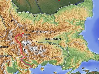
Blagoevgrad Province, also known as Pirin Macedonia or Bulgarian Macedonia, is a province (oblast) of southwestern Bulgaria. It borders four other Bulgarian provinces to the north and east, the Greek region of Macedonia to the south, and North Macedonia to the west. The province has 14 municipalities with 12 towns. Its principal city is Blagoevgrad, while other significant towns include Bansko, Gotse Delchev, Melnik, Petrich, Razlog, Sandanski, and Simitli.

<span class="mw-page-title-main">Pirin</span> Mountain range in southwestern Bulgaria

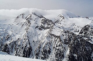
The Pirin Mountains are a mountain range in southwestern Bulgaria, with the highest peak, Vihren, at an altitude of 2,914 m (9,560 ft).

<span class="mw-page-title-main">Simitli</span> Town in Blagoevgrad, Bulgaria

Simitli also known as Simitliya, is a town in Blagoevgrad Province in southwestern Bulgaria. It has a population of 7,454 and is located 17 km south of Blagoevgrad. It is the seat of Simitli Municipality.

<span class="mw-page-title-main">Pirin National Park</span> National park in Bulgaria

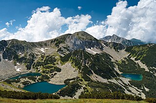
Pirin National Park, originally named Vihren National Park, encompasses the larger part of the Pirin Mountains in southwestern Bulgaria, spanning an area of 403.56 square kilometers (155.82 sq mi).

<span class="mw-page-title-main">European route E79</span> Road in trans-European E-road network

European route E 79 is a road part of the International E-road network. It begins in Miskolc, Hungary and ends in Thessaloniki, Greece, also running through Romania and Bulgaria. The road is 1,300 km (810 mi) long.

<span class="mw-page-title-main">Struma motorway</span> Road in Bulgaria

The Struma Motorway is a motorway currently under construction in Bulgaria. The motorway is located in the Yugozapaden area in South West Bulgaria, and follows the route Sofia-Pernik-Dupnitsa-Blagoevgrad-Sandanski to Kulata on the border with in Greece. It is part of the Pan-European Corridor IV and also is part of Е79, that runs from Miskolc (Hungary) to Thessaloniki (Greece), via the Romanian cities of Deva and Craiova. This project is under the European Union's Ten-T Priority Projects. The road is also part of the proposed Via Carpatia route.

<span class="mw-page-title-main">Kresna</span> Place in Blagoevgrad, Bulgaria

Kresna is a town and the seat of Kresna Municipality in Blagoevgrad Province in Bulgaria.

<span class="mw-page-title-main">Highways in Bulgaria</span>

Highways in Bulgaria are dual carriageways, grade separated with controlled-access, designed for high speeds. In 2012, legislation amendments defined two types of highways: motorways and expressways. The main differences are that motorways have emergency lanes and the maximum allowed speed limit is 140 km/h (87 mph), while expressways do not and the speed limit is 120 km/h (75 mph). As of October 2023, a total of 879,1 kilometers of motorways are in service.

<span class="mw-page-title-main">Pan-European Corridor IV</span> Road in Europe

The Corridor IV is one of the Pan-European transport corridors. It runs between Dresden/Nuremberg in Germany and Thessaloniki (Greece) / Constanța (Romania) / Istanbul (Turkey). The corridor follows the route: Dresden / Nuremberg – Prague – Vienna – Bratislava – Győr – Budapest – Arad – Bucharest – Constanța / Craiova – Sofia – Pernik - Thessaloniki or Plovdiv – Istanbul.

Kresna Gorge Tunnel was a planned twin-tube tunnel in Blagoevgrad Province, Bulgaria. The tunnel would be part of Struma motorway (A3), that runs between Sofia and the border crossing to Greece, at the village of Kulata.

<span class="mw-page-title-main">I-1 road (Bulgaria)</span> Road in Bulgaria

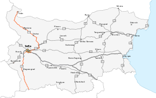
Republic road I-1 is a major road in western Bulgaria. It runs between the New Europe Bridge, at the Danube border with Romania, and the village of Kulata, at the border crossing to Greece. The total length of the road is 453.8 km (282.0 mi). Most of it provides one driving lane per direction and it is planned to be superseded or replaced in all sections by either motorways, or expressways.

<span class="mw-page-title-main">Stara Reka Reserve</span>

Stara Reka is one of the nine nature reserves in the Central Balkan National Park in central Bulgaria. Stara Reka was established on 19 March 1981 to protect the unique ecosystems of the Balkan Mountains. It spans an area of 1974.7 hectares, or 19.747km2.

CEE Bankwatch Network is a global network which operates in central and eastern Europe. There are 17 member groups, multiple non-governmental organizations based in different locations; the network is one of the largest networks of environmental NGOs in central and eastern Europe. Bankwatch's headquarters rest in Prague, Czech Republic.

<span class="mw-page-title-main">Tisata</span> Nature reserve in south-western Bulgaria

Tisata is a nature reserve in south-western Bulgaria. It is situated in Kresna Municipality, Blagoevgrad Province. The reserve is managed by the administration of Pirin National Park despite the fact it lies outside the limits of the park.

<span class="mw-page-title-main">Melnik Earth Pyramids</span> Geological formation in southwestern Bulgaria

The Melnik Earth Pyramids are rock formations, known as hoodoos, situated at the foothills of the Pirin mountain range in south-western Bulgaria. They span an area of 17 km2 near the town of Melnik, Blagoevgrad Province. Reaching a height of up to 100 m these sandstone pyramids are shaped in forms, resembling giant mushrooms, ancient towers and obelisks. They were formed primarily due to erosion from rainfall and bedrock wear. The Melnik Earth Pyramids are a geological phenomenon of global importance and were declared a natural landmark in 1960. The rock formations are home to rich flora and fauna heavily influenced by the Mediterranean climate. They are a tourist destination due to the natural environment of the area, the cultural sights of Melnik and the Rozhen Monastery.

<span class="mw-page-title-main">Crete Mediterranean forests</span>

The Crete Mediterranean forests is a terrestrial ecoregion that encompasses the Greek island of Crete.

<span class="mw-page-title-main">Sandanski–Petrich Valley</span> Valley in Bulgaria

Sandanski–Petrich Valley is situated in southwestern Bulgaria along the river Struma and its right tributary Strumeshnitsa, with a very small part of the territory extending to Greece. The valley is enclosed by several mountain ranges, three of them reaching heights of over 2,000 m, and is open to the Strumitsa Valley to the west and the Serres Valley to the south. Due to the proximity to the Aegean Sea, the climate is continental Mediterranean, making Sandanski–Petrich Valley one of the warmest regions of Bulgaria.

<span class="mw-page-title-main">Zheleznitsa Tunnel</span> Road tunnel in Bulgaria

The Zheleznitsa Tunnel is a 2-kilometre (1.2 mi) highway twin tunnel on the Struma motorway in Blagoevgrad Province, southwestern Bulgaria. It is the longest road tunnel in Bulgaria. The tunnel is named after the village of Zheleznitsa, which it bypasses between the towns of Blagoevgrad and Simitli.

References

  1. "Struma Motorway". ebrd.com. Retrieved 2017-11-08.
  2. "LIFE for Kresna Gorge". rewildingeurope.com. Archived from the original on 2017-11-09. Retrieved 2017-11-08.
  3. Balkan Wars 1912-1913 PDF; Page 12
  4. "Kresna Gorge". fwff.org. Retrieved 2017-11-08.
  5. "Five Threats to Nature" (PDF). assets.panda.org. Retrieved 2017-11-08.
  6. 1 2 "Kresna Gorge". klooiplek.eu. Archived from the original on 2017-11-08. Retrieved 2017-11-08.
  7. "Egyptian Vulture (Neophron percnopterus)". fwff.org. Archived from the original on 2017-11-08. Retrieved 2017-11-08.
  8. "EU money should not help destroy Bulgaria's Kresna Gorge". euractiv.com. 29 March 2016. Retrieved 2017-11-08.
  9. "Struma Motorway Lot 3.2" (PDF). ncsip.bg. Retrieved 2017-11-08.
  10. 1 2 "Bulgarian motorway poised to carve up wildlife haven". theguardian.com. 17 February 2016. Retrieved 2017-11-08.
  11. Onthullende video: EU financiert strijdende partijen in Bulgarije, DDS, Olaf Stuger, 25 June 2019. Consulted 5 July 2020.