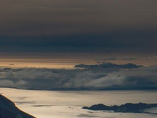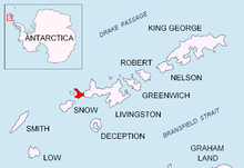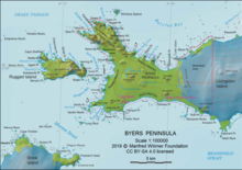
Rugged Island is an island 3 miles (4.8 km) long and 1 mile (1.6 km) wide, lying west of Livingston Island in the South Shetland Islands. Its surface area is 10.4 square kilometres (4.0 sq mi). The island's summit San Stefano Peak rises to 256 metres (840 ft) above sea level. Rugged Island is located at 62°38′S61°15′W. Rugged Island was known to both American and British sealers as early as 1820, and the name has been well established in international usage for over 100 years.

Hesperides Hill is a ridge linked by a saddle of elevation 52 m with the northern slopes of Atlantic Club Ridge on Hurd Peninsula, eastern Livingston Island in the South Shetland Islands, Antarctica. The hill surmounts the South Bay coast north of Johnsons Dock to the southwest, and Bulgarian Beach to the northeast and is bounded to the southwest by Sea Lion Glacier. The ridge extends 420 m in south-southeast to north-northwest direction and is 250 m wide and narrowing towards north-northwest. Hesperides Hill has two heights, 94 and 63 m, the latter surmounting Hespérides Point. The hill is snow-free in summer months and is named from the adjacent Hespérides Point.

Osogovo Bay, "named after the Osogovo region in western Bulgaria," is bounded by the south coast of Rugged Island, by Astor Island, and by the west coast of the Byers Peninsula south of Laager Point, Livingston Island in the South Shetland Islands, Antarctica.

Spanish Knoll has a highest point of elevation 48 m located on Bulgarian Beach on Hurd Peninsula, eastern Livingston Island in the South Shetland Islands, Antarctica.

Spanish Point is located on Bulgarian Beach on Hurd Peninsula, eastern Livingston Island in the South Shetland Islands, Antarctica formed by an offshoot of Spanish Knoll.

Cape Shirreff is a prominent cape at the north end of the rocky peninsula which separates Hero Bay and Barclay Bay on the north coast of Livingston Island, in the South Shetland Islands of Antarctica. The cape was named by Edward Bransfield in 1820 after Captain William H. Shirreff, the British commanding officer in the Pacific at that time.

Williams Point is the point forming both the north extremity of Varna Peninsula and the northeast tip of Livingston Island in the South Shetland Islands, Antarctica. Separated from Zed Islands to the north by Iglika Passage.

Hurd Peninsula lies between South Bay and False Bay on the south coast of Livingston Island in the South Shetland Islands, Antarctica. The Spanish Juan Carlos I Antarctic Base and the Bulgarian St. Kliment Ohridski Base are situated on its west coast.

New Plymouth is a bay bordered by an extensive line of beaches, lying south of Start Point and between Rugged Island and the west end of Livingston Island in the South Shetland Islands, Antarctica.

Robbery Beaches are beaches extending along the north side of Byers Peninsula, Livingston Island in the South Shetland Islands, Antarctica between Essex Point to the west and Nedelya Point to the east. They are crossed by Eridanus Stream and Bedek Stream.

Lister Cove is a 2.1 km wide cove indenting for 1.55 km the northeast coast of Varna Peninsula, Livingston Island in the South Shetland Islands, Antarctica south of Pomorie Point and north of Karavelova Point. The cove is fed by Rose Valley Glacier.

Johnsons Dock is a sheltered 500 m wide cove indenting for 900 m the northwest coast of Hurd Peninsula on Livingston Island in the South Shetland Islands, Antarctica. It is part of South Bay entered north of Ballester Point. Surmounted by Charrúa Ridge on the northeast. The cove was frequented by early 19th century sealers.

Essex Point is a point at the northwest end of Byers Peninsula, Livingston Island in the South Shetland Islands, Antarctica. It forms the west side of the entrance to Barclay Bay and the northeast side of the entrance to Svishtov Cove, and is surmounted by Drong Hill.

Ray Promontory is the 7 km long and 2.8 km wide promontory lying between Barclay Bay and the New Plymouth sound, and forming the northwest part of Byers Peninsula, Livingston Island in the South Shetland Islands, Antarctica ending up in Start Point and Essex Point. The promontory's interior is mostly occupied by Dospey Heights.

Window Island is a small ice-free island off the north coast of Ray Promontory in the northwest of Byers Peninsula, Livingston Island in the South Shetland Islands, Antarctica. The island has a surface area of 23 hectares and rises to 72 m (236 ft). It was known to the early 19th century sealers operating on Byers Peninsula.

South Beaches are the beaches extending along the south side of Byers Peninsula, Livingston Island in the South Shetland Islands, Antarctica between Devils Point to the west and Rish Point to the east. The beaches were visited by 19th century sealers.

Lair Point is a point projecting 570 m into Barclay Bay from Robbery Beaches on Byers Peninsula, Livingston Island in the South Shetland Islands, Antarctica and forming the east side of the entrance to Kukuzel Cove. Dominated by Lair Hill.

Point Smellie is a small steep-sided headland extending into Osogovo Bay from President Beaches on Byers Peninsula, Livingston Island in the South Shetland Islands, Antarctica and dominated by Smellie Hill.

Richards Cove is the 450 m wide cove indenting for 550 m the north coast of Ray Promontory, Byers Peninsula, Livingston Island in the South Shetland Islands, Antarctica, entered east of Aglen Point and west of Voyteh Point. The area was visited by early 19th century sealers.

Guangzhou Peninsula is the mostly ice-free peninsula forming the west extremity of Nelson Island in the South Shetland Islands, Antarctica and ending up in Harmony Point. It is bounded by Harmony Cove and Nelson Strait on the south and southwest, and Malak Sechko Cove and Golyam Sechko Cove in Drake Passage on the northwest, extends 3.4 km in northeast–southwest direction and 2.7 km in southeast–northwest direction, and has a surface area of 5.02 km2. The area was visited by early 19th century sealers based at Harmony Cove.


