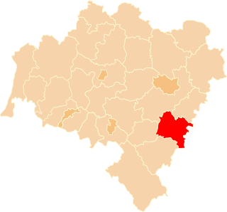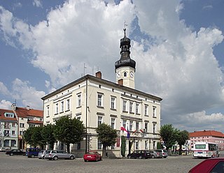
Wiązów is a town in Strzelin County, Lower Silesian Voivodeship, in south-western Poland. It is the seat of the administrative district (gmina) called Gmina Wiązów. The town lies approximately 11 kilometres (7 mi) east of Strzelin, and 37 kilometres (23 mi) south of the regional capital Wrocław.

Bryłów is a village in the administrative district of Gmina Wiązów, within Strzelin County, Lower Silesian Voivodeship, in south-western Poland.
Bryłówek is a village in the administrative district of Gmina Wiązów, within Strzelin County, Lower Silesian Voivodeship, in south-western Poland.
Częstocice is a village in the administrative district of Gmina Wiązów, within Strzelin County, Lower Silesian Voivodeship, in south-western Poland.
Janowo is a village in the administrative district of Gmina Wiązów, within Strzelin County, Lower Silesian Voivodeship, in south-western Poland. Prior to 1945 it was in Germany.
Jutrzyna is a village in the administrative district of Gmina Wiązów, within Strzelin County, Lower Silesian Voivodeship, in south-western Poland. Prior to 1945 it was in Germany.
Kalinowa is a village in the administrative district of Gmina Wiązów, within Strzelin County, Lower Silesian Voivodeship, in south-western Poland. Prior to 1945 it was in Germany.
Kowalów is a village in the administrative district of Gmina Wiązów, within Strzelin County, Lower Silesian Voivodeship, in south-western Poland. Prior to 1945 it was in Germany. It lies approximately 7 kilometres (4 mi) south of Wiązów, 12 km (7 mi) east of Strzelin, and 43 km (27 mi) south of the regional capital Wrocław.
Krajno is a village in the administrative district of Gmina Wiązów, within Strzelin County, Lower Silesian Voivodeship, in south-western Poland. Prior to 1945 it was in Germany. It lies approximately 8 kilometres (5 mi) south-east of Wiązów, 14 km (9 mi) east of Strzelin, and 45 km (28 mi) south of the regional capital Wrocław.
Łojowice is a village in the administrative district of Gmina Wiązów, within Strzelin County, Lower Silesian Voivodeship, in south-western Poland. It lies approximately 10 kilometres (6 mi) south of Wiązów, 12 km (7 mi) south-east of Strzelin, and 46 km (29 mi) south of the regional capital Wrocław.
Ośno is a village in the administrative district of Gmina Wiązów, within Strzelin County, Lower Silesian Voivodeship, in south-western Poland. Prior to 1945 it was in Germany.
Witowice is a village in the administrative district of Gmina Wiązów, within Strzelin County, Lower Silesian Voivodeship, in south-western Poland. Prior to 1945 it was in Germany. It lies approximately 3 kilometres (2 mi) north-east of Wiązów, 12 km (7 mi) north-east of Strzelin, and 35 km (22 mi) south of the regional capital Wrocław.
Wyszonowice is a village in the administrative district of Gmina Wiązów, within Strzelin County, Lower Silesian Voivodeship, in south-western Poland. Prior to 1945 it was in Germany.
Zborowice is a village in the administrative district of Gmina Wiązów, within Strzelin County, Lower Silesian Voivodeship, in south-western Poland. Prior to 1945 it was in Germany. It lies approximately 3 kilometres (2 mi) south-west of Wiązów, 9 km (6 mi) east of Strzelin, and 38 km (24 mi) south of the regional capital Wrocław.
Jaworów is a village in the administrative district of Gmina Wiązów, within Strzelin County, Lower Silesian Voivodeship, in south-western Poland. Prior to 1945 it was in Germany.
Miechowice Oławskie is a village in the administrative district of Gmina Wiązów, within Strzelin County, Lower Silesian Voivodeship, in south-western Poland. Prior to 1945 it was in Germany.
Wolaniny is a village in the administrative district of Gmina Biłgoraj, within Biłgoraj County, Lublin Voivodeship, in eastern Poland. It lies approximately 6 kilometres (4 mi) east of Biłgoraj and 82 km (51 mi) south of the regional capital Lublin.
Podlisów is a village in the administrative district of Gmina Wojciechowice, within Opatów County, Świętokrzyskie Voivodeship, in south-central Poland. It lies approximately 5 kilometres (3 mi) south of Wojciechowice, 11 km (7 mi) east of Opatów, and 68 km (42 mi) east of the regional capital Kielce.

Gotem is a small town in the Limburg province of Belgium and is part of the municipality of Borgloon.