Stateline, California

Last updated
Stateline
Stateline, California.jpg
USA California location map.svg
Red pog.svg
Stateline
Location in California
Coordinates: 38°57′30″N119°56′38″W / 38.95833°N 119.94389°W / 38.95833; -119.94389 Coordinates: 38°57′30″N119°56′38″W / 38.95833°N 119.94389°W / 38.95833; -119.94389
Country United States
State California
County El Dorado County
City South Lake Tahoe
Settled1850s
Elevation
[1]
6,279 ft (1,914 m)

Stateline (formerly Lakeside and Laphams) [2] [3] is a former unincorporated community in El Dorado County, California, now incorporated into South Lake Tahoe, California. [1] It lies at an elevation of 6,279 feet (1914 m) ASL. [1] As its name suggests, it is at the state line with Nevada, and mirrors the adjacent community of the same name.

The name Laphams commemorates William W. Lapham who opened a hotel here in the 1850s. [2] The pony express route ran through the community circa 1861 on the leg between Friday's Station and Yanks. A post office operated at Stateline from 1901. [2] It was along the Lincoln Highway Sierra Nevada Southern Route by 1916. The locale acquired the name Lakeside between 1930 [4] and 1955; [3] then was changed to Stateline thereafter. [5] The community was a subject in an interstate border dispute. [6] After a 1980 US Supreme Court ruling, the community of Stateline was nominally moved east, and the California portion dissolved into South Lake Tahoe. [7] [8] [9] The currently accepted interstate border is marked by the 1893 US CGS Federal Survey Monuments No. 1, [10] [11] [7] No. 2, [12] [7] and No.3. [13] [7] Disturbing survey monuments is illegal. [14] [15] [16] [17] as is land title fraud. [15] [18] [19]

Related Research Articles

<span class="mw-page-title-main">Stateline, Nevada</span> CDP in Nevada, United States

Stateline is a census-designated place (CDP) on the southeastern shore of Lake Tahoe in Douglas County, Nevada, United States. It lies next to the California state line and City of South Lake Tahoe. The population was 842 at the 2010 census. The population swells considerably during the busy winter and summer seasons, due to the high number of hotel rooms and rental accommodations available.

<span class="mw-page-title-main">Lake Tahoe</span> Lake in California and Nevada, United States

Lake Tahoe is a large freshwater lake in the Sierra Nevada of the United States. Lying at 6,225 ft (1,897 m), it straddles the state line between California and Nevada, west of Carson City. Lake Tahoe is the largest alpine lake in North America, and at 122,160,280 acre⋅ft (150.7 km3) it trails only the five Great Lakes as the largest by volume in the United States. Its depth is 1,645 ft (501 m), making it the second deepest in the United States after Crater Lake in Oregon.

Pyramid Peak (California)

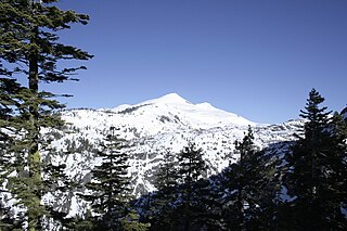
Pyramid Peak is a mountain in the California's Sierra Nevada in the Crystal Range to the west of Lake Tahoe. It is the highest point in the Desolation Wilderness. With an elevation gain of almost 4,100 feet (1,250 m), the Rocky Canyon route is the mountain's most popular approach although it is very arduous. To the east, at the base of the peak, lies Pyramid Lake.

<span class="mw-page-title-main">Survey marker</span>

Survey markers, also called survey marks, survey monuments, or geodetic marks, are objects placed to mark key survey points on the Earth's surface. They are used in geodetic and land surveying. A benchmark is a type of survey marker that indicates elevation. Horizontal position markers used for triangulation are also known as triangulation stations. Benchmarking is the hobby of "hunting" for these marks.

Meyers is a small unincorporated community in El Dorado County, California, United States, along U.S. Route 50 in the northern Sierra Nevada. It is 6 miles (10 km) south of South Lake Tahoe in the Lake Tahoe area and lies at an elevation of 6,352 feet. Established in 1851, Meyers started out as a stagecoach stop, trading post and Pony Express station. The town is now registered as California Historical Landmark #708. It serves as a popular stop on the way into and out of the Tahoe Basin for travelers on Highways 50 and 89.

<span class="mw-page-title-main">Al Tahoe, California</span> Place in California, United States

Al Tahoe is a former unincorporated community now incorporated in South Lake Tahoe in El Dorado County, California. It lies at an elevation of 6253 feet. The community was named for the Al Tahoe Hotel, which was built in 1907 by Almerin R. Sprague. In the 1800s, the community was called Rowlands.

<span class="mw-page-title-main">Bijou, California</span> Place in California, United States

Bijou is a former unincorporated community now incorporated in South Lake Tahoe in El Dorado County, California. It lies at an elevation of 6243 feet.

Camp Richardson, California Unincorporated community in California, United States

Camp Richardson is an unincorporated community at Lake Tahoe, in El Dorado County, California. It lies at an elevation of 6250 feet in the Sierra Nevada.

Lake Valley is an unincorporated community in El Dorado County, California. It extends for 8 miles (13 km) along the Upper Truckee River from Lake Tahoe to Meyers, at an elevation of 6207 feet.

Fridays Station United States historic place

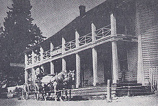
Friday's Station, on US 50 between Kingsbury Grade and Loop Road in Stateline, Nevada, is a two-story wood-frame white building built as a Pony Express station and inn in 1860. In 1986, it was known as Park Cattle Company Residence and was listed on the National Register of Historic Places. The two-story wood-frame white building is visible from U.S. Route 50 near the California-Nevada border at Stateline, Nevada.

References

  1. 1 2 3 U.S. Geological Survey Geographic Names Information System: Stateline, California
  2. 1 2 3 Durham, David L. (1998). California's Geographic Names: A Gazetteer of Historic and Modern Names of the State. Clovis, Calif.: Word Dancer Press. p. 561. ISBN   1-884995-14-4.
  3. 1 2 United States Geological Survey (1955). Markleeville Sheet (JPEG) (Topographic map). 1:125,000. Reston VA: US Geological Survey. Retrieved July 17, 2018.
  4. United States Geological Survey (1930). Markleeville Sheet (JPEG) (Topographic map). 1:125,000. Reston VA: US Geological Survey. Retrieved July 17, 2018.
  5. United States Geological Survey (1957). Bijou, Calif.-Nev (JPEG) (Topographic map). 1:24,000. 7.5 Minute Series. Reston VA: US Geological Survey. Retrieved July 17, 2018.
  6. California v. Nevada, 44U.S.125 (US Supreme Court1980).
  7. 1 2 3 4 United States Geological Survey (1982). South Lake Tahoe, Calif.—Nev (JPEG) (Topographic map). 1:24,000. 7.5 Minute Series. Reston VA: US Geological Survey. Retrieved July 17, 2018.
  8. United States Geological Survey (1992). South Lake Tahoe, Calif.—Nev (JPEG) (Topographic map). 1:24,000. 7.5 Minute Series. Reston VA: US Geological Survey. Retrieved July 17, 2018.
  9. United States Geological Survey (1891). Markleeville Sheet (JPEG) (Topographic map). 1:125,000. Reston VA: US Geological Survey. Retrieved July 17, 2018.
  10. "NGS Data Sheet - INITIAL MON 1 CA NV". Survey Marks and Datasheets. NOAA: National Geodetic Survey.
  11. "Granite Boundary Monument No. 1 - South Lake Tahoe CA". Waymarking.com. Groundspeak, Inc. Retrieved 20 June 2018.
  12. "NGS Data Sheet - BOUNDARY MON 2 CA NV". Survey Marks and Datasheets. NOAA: National Geodetic Survey.
  13. "NGS Data Sheet - BOUNDARY MON 3 TEMP POINT". Survey Marks and Datasheets. NOAA: National Geodetic Survey.
  14. "18 US Code § 1858 - Survey marks destroyed or removed". United States Code. US. Whoever willfully destroys, defaces, changes, or removes to another place any section corner, quarter-section corner, or meander post, on any Government line of survey, or willfully cuts down any witness tree or any tree blazed to mark the line of a Government survey, or willfully defaces, changes, or removes any monument or bench mark of any Government survey, shall be fined under this title or imprisoned
  15. 1 2 "18 US Code § 1001 - Statements or entries generally". United States Code. US. whoever, in any matter within the jurisdiction of ...the Government of the United States, knowingly and willfully—(1) falsifies, conceals, or covers up by any trick, scheme, or device a material fact;...shall be fined under this title, imprisoned not more than 5 years
  16. "Business and Professions Code - §8771 Setting of monuments in general; monument perpetuation" (PDF). State of California.
  17. "36 CFR Part 800 - Protection of Historic Properties". Code of Federal Regulation. US.
  18. "Calif. Evidence Code 668". State of California. An unlawful intent is presumed from the doing of an unlawful act. This presumption is inapplicable in a criminal action to establish the specific intent of the defendant where specific intent is an element of the crime charged.
  19. "California Code, Penal Code - PEN § 484". State of California. Every person …who shall knowingly and designedly, by any false or fraudulent representation or pretense, defraud any other person of … real or personal property … is guilty of theft