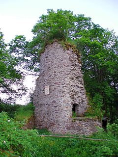
The Königsburg is a ruined medieval castle southeast of Königshütte, a village in the borough of Oberharz am Brocken, in Harz district in the German state of Saxony-Anhalt.
Rieder is a village and a former municipality in the district of Harz, in Saxony-Anhalt, Germany. Since 1 December 2013, it is part of the town Ballenstedt. Between 1 January 2011 and 19 February 2013, it was part of the town Quedlinburg.

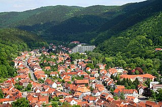
Sankt Andreasberg is a former town in the district of Goslar, in Lower Saxony, Germany. Since 1 November 2011, it is part of the town Braunlage. It is situated in the Harz, approximately 7 km west of Braunlage proper, and 20 km east of Osterode am Harz.
Bad Lauterberg is a town in the district of Göttingen, in Lower Saxony, Germany. It is situated in the southern Harz, approx. 15 km southwest of Braunlage, and 20 km southeast of Osterode am Harz.

Hasselfelde is a town in the district of Harz, in Saxony-Anhalt, Germany. It is situated in the eastern Harz, approximately 17 km south of Wernigerode. Since 1 January 2010, it is part of the town Oberharz am Brocken. As of 1 January 2010 Hasselfelde has 2,390 inhabitants.
Zorge is a village and a former municipality in the district of Göttingen, in Lower Saxony, Germany. Since 1 November 2016 it has been part of the municipality of Walkenried. The river Zorge rises in the village.

The Harzer Wandernadel is a system of hiking awards in the Harz mountains in central Germany. The hiker can earn awards at different levels of challenge by walking to the various checkpoints in the network and stamping his or her passbook to record the visit. With 222 checkpoints in three federal states and across five districts in the Harz and with membership in five figures, the system has gained a following Germany-wide.

Söse is a river of Lower Saxony, Germany. It is a right tributary of the river Rhume and 38 kilometres (24 mi) long.

The Harz Witches' Trail is a footpath, just under 100 km long, in Germany that runs from Osterode through the Harz mountains and over its highest peak, the Brocken, to Thale. It is a project by the Harz Transport Association and Harz Club and is part of the system of trails known as the Harzer Wandernadel.

The Hoher Kleef is a rock formation in Rübeland in the district of Harz within the Harz mountains of Germany. It is mainly composed of granite.

Trautenstein is a village in the borough of Oberharz am Brocken in the district of Harz in the German state of Saxony-Anhalt. Trautenstein has 493 inhabitants as of 1 January 2010. Formerly an independent municipality, it was merged into the town Hasselfelde in 2002, which was merged into Oberharz am Brocken in 2010.

The Froschfelsen, also called the Froschsteinklippe, is a natural monument near Ilsenburg in the northern Harz in central Germany. It is a formation of granite rocks that take the shape of a frog, hence the name.
The Bielstein Tunnel is a disused railway tunnel in Saxony-Anhalt in the Harz Mountains of Central Germany. The tunnel is 465.7 metres long and lies between the zig zag of Michaelstein and Braunesumpf. It belonged to the Erzstufen Railway and, from 1885, to the Harz Railway . During the construction of the Harz Railway the tunnel profile was widened and Braunesumpf station laid out. When the Rübeland Railway was electrified from 1960 to 1965 the tunnel profile had to be widened again. In addition the tunnel was found to be in poor condition so that it was abandoned and the line was relaid further east through a cutting. The tunnel is no longer accessible today.
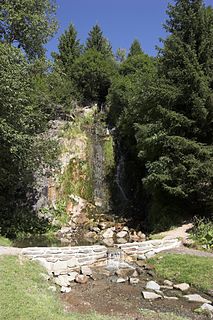
Königshütte Waterfall is a waterfall in the village of Königshütte in the borough of Oberharz am Brocken in the Harz Mountains of Central Germany.

The Bremen Hut in the Harz Mountains is a refuge hut and shelter in that part of the Harz National Park lying within the borough of Ilsenburg (Harz) in Harz district in the German state of Saxony-Anhalt.
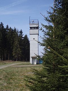
The Sorge Border Museum is an open-air museum that is open to the public and free of charge near Sorge in the Harz Mountains of central Germany. It is located immediately by the former Inner German Border, southeast of Braunlage and aims to recall the division of Germany into East and West Germany.

A Köte is the term used in the Harz Mountains of central Germany for a charcoal burner's hut (Köhlerhütte). A Köte was occupied by a charcoal burner in order to look after a nearby wood pile (Kohlenmeiler). The charcoal burner prepared the necessary charcoal for the smelting of ores.
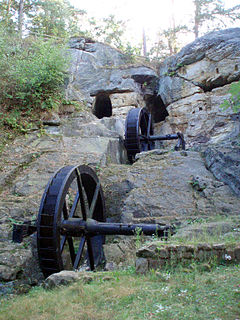
The Regenstein Mill was a water-powered corn and oil mill below Regenstein Castle north of the town of Blankenburg (Harz) in the county of Harz (Saxony-Anhalt).
The Scharfenstein is a hill spur, 462.4 m above sea level (NN), of the Eichberg-Süd (486.4 m) in the Harz Mountains of Germany, near the town of Wernigerode in the county of Harz in Saxony-Anhalt.
The Jagdkopf a hill, 603.1 m above sea level (NN) high, in the Harz Mountains of Germany. It is located between the villages of Wieda and Zorge in the unincorporated area of Harz in the district of Göttingen in the state of Lower Saxony.


