Pensacola International Airport, formerly Pensacola Gulf Coast Regional Airport and Pensacola Regional Airport, is a public use airport three nautical miles northeast of the central business district of Pensacola, in Escambia County, Florida, United States. It is owned by the City of Pensacola. Despite its name, the airport does not offer scheduled international flights, though chartered international flights are not uncommon. This airport is one of the five major airports in North Florida, and among these is the second largest by passenger count, only behind Jacksonville. The other airports in the North Florida region are: Northwest Florida Beaches International Airport, Destin-Fort Walton Beach Airport, Tallahassee International Airport, and Jacksonville International Airport.
The visual approach slope indicator (VASI) is a system of lights on the side of an airport runway threshold that provides visual descent guidance information during final approach. These lights may be visible from up to 8 kilometres (5.0 mi) during the day and up to 32 kilometres (20 mi) or more at night.

Olympia Regional Airport is a public use airport located four nautical miles (7 km) south of the central business district of Olympia, a city in Thurston County and the capital of the U.S. state of Washington. It is owned by the Port of Olympia. It is about one mile (1.6 km) east of Interstate 5, actually within the boundaries of the city of Tumwater which is south of and adjacent to Olympia. The airport was identified in the Washington State Department of Transportation Long Term Aviation Study as a field that could potentially serve to relieve Seattle-Tacoma International Airport of increasing congestion.

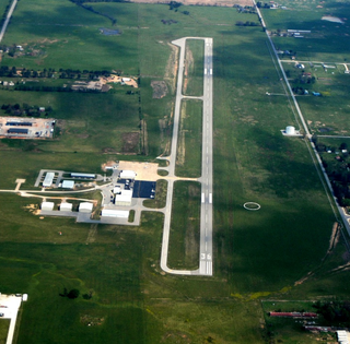
McKinney National Airport, formerly Collin County Regional Airport at McKinney, is a general aviation airport located in McKinney, Texas, United States, about 30 miles north of downtown Dallas.

Danbury Municipal Airport is a public use general aviation and commercial airport located three miles (5 km) southwest of the central business district of Danbury, in Fairfield County, Connecticut, United States. The airport opened in 1930. It is currently run by the City of Danbury under the management of Michael Safranek. It is included in the Federal Aviation Administration (FAA) National Plan of Integrated Airport Systems for 2017–2021, in which it is categorized as a regional reliever airport facility.

York Airport (York Aviation) (IATA: THV, ICAO: KTHV, FAA LID: THV) is a privately owned, public use airport that is located seven nautical miles (8 mi, 13 km) southwest of the central business district of York in the Thomasville section of Jackson Township, York County, Pennsylvania, United States.
Iowa City Municipal Airport, is two miles southwest of downtown Iowa City, in Johnson County, Iowa. It is the oldest civil airport west of the Mississippi River still in its original location.

Sandusky County Regional Airport is a county-owned public-use airport located five nautical miles (9 km) southeast of the central business district of Fremont, a city in Sandusky County, Ohio, United States.

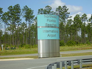
Northwest Florida Beaches International Airport is a public airport 18 miles (29 km) northwest of Panama City, Florida, United States, in Bay County. The airport is owned by the Panama City-Bay County Airport & Industrial District, and is north of Panama City Beach, near West Bay. It replaced Panama City–Bay County International Airport, which was located in Panama City.
Northeast Ohio Regional Airport, owned and operated by the Ashtabula County Airport Authority, is a public-use airport in Ashtabula County, Ohio, United States, eight nautical miles (15 km) southeast of the central business district of the city of Ashtabula. Airport is located in Denmark Township near the Village of Jefferson, which is the County Seat of Ashtabula County. Located within minutes of Lake Erie and the intersection of major Interstates 90 (East/West) and 11 (North/South), the convenient location of the Northeast Ohio Regional Airport (HZY) makes it the perfect choice for both corporate and private travelers. The airport is located in the village of Jefferson, about 10 miles (16 km) south of Lake Erie. According to the FAA's National Plan of Integrated Airport Systems for 2009–2013, it is classified as a general aviation airport.

Smith Field is a city-owned, public-use airport located three nautical miles northeast of the central business district of Siloam Springs, a city in Benton County, Arkansas, United States. According to the FAA's National Plan of Integrated Airport Systems for 2009–2013, it is categorized as a general aviation airport.

Goheen Airport is a privately owned, public use airport located three nautical miles (6 km) northwest of the central business district of Battle Ground, a city in Clark County, Washington, United States.

Mid-Way Regional Airport is city-owned public airport that serves Midlothian and Waxahachie in Ellis County, Texas, United States. The airport is 5 nautical miles (9.3 km) southeast of the central business district of Midlothian.
Crawfordsville Regional Airport is a public use airport located 4 miles (6.4 km) south of the central business district of Crawfordsville, a city in Montgomery County, Indiana, United States. The airport was founded in June 1945 and is owned by the city. It is included in the Federal Aviation Administration (FAA) National Plan of Integrated Airport Systems for 2021–2025, in which it is categorized as a local general aviation facility.
Ontonagon County Airport, also known as Schuster Field, is a county-owned public-use airport located 3 miles (5 km) west of the central business district of Ontonagon, Michigan, a village in Ontonagon County, Michigan, United States. It is included in the Federal Aviation Administration (FAA) National Plan of Integrated Airport Systems for 2021–2025, in which it is categorized as a basic general aviation facility.

Schoolcraft County Airport is a county-owned public-use airport located 3 miles (5 km) northeast of the central business district of Manistique, Michigan, a city in Schoolcraft County, Michigan, United States. It is included in the Federal Aviation Administration (FAA) National Plan of Integrated Airport Systems for 2017–2021, in which it is categorized as a basic general aviation facility.
Grinnell Regional Airport, known locally as Billy Robinson Field, is a city-owned public-use airport located one mile (1.6 km) south of the central business district of Grinnell, a city in Poweshiek County, Iowa, United States. It is included in the National Plan of Integrated Airport Systems for 2017–2021, which categorized it as a local general aviation facility.

Aztec Municipal Airport is a public-use airport located two nautical miles northwest of the central business district of Aztec, in San Juan County, New Mexico, United States. It is a general aviation airport with no tower, fixed base operator (FBO), or commercial services, but which is popular among smaller light sport and general aviation aircraft doing cross country flights, where the airport serves as a GA-friendly waypoint, refueling stop, and overnight layover stop.

City of Slaton/Larry T. Neal Memorial Airport is a General Aviation airport located 3.4 mi (5.5 km) north of Slaton, Texas.


