Related Research Articles
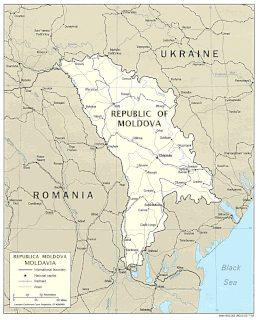
Located in Eastern Europe, Moldova is bordered on the west and southwest by Romania and on the north, south, and east by Ukraine. Most of its territory lies between the area's two main rivers, the Nistru and the Prut. The Nistru forms a small part of Moldova's border with Ukraine in the northeast and southeast, but it mainly flows through the eastern part of the country, separating Bessarabia and Transnistria. The Prut River forms Moldova's entire western boundary with Romania. The Danube touches the Moldovan border at its southernmost tip, and forms the border for 200 m (656 ft).

In physical geography, a steppe is an ecoregion characterized by grassland plains without trees apart from those near rivers and lakes. Steppe biomes may include:

Temperate grasslands, savannas, and shrublands is a terrestrial habitat type defined by the World Wide Fund for Nature. The predominant vegetation in this biome consists of grass and/or shrubs. The climate is temperate and ranges from semi-arid to semi-humid. The habitat type differs from tropical grasslands in the annual temperature regime as well as the types of species found here.

The Palearctic or Palaearctic is one of the eight biogeographic realms of the Earth. It was first used in the 19th century, and is still in use as the basis for zoogeographic classification. The Palearctic is the largest of the eight realms. It stretches across all of Eurasia north of the foothills of the Himalayas, and North Africa.
![Afrotropical realm One of the Earths eight [[biogeographic realm]]s](https://upload.wikimedia.org/wikipedia/commons/thumb/8/8d/Ecozone_Afrotropic.svg/320px-Ecozone_Afrotropic.svg.png)
The Afrotropical realm is one of the Earth's eight biogeographic realms. It includes Africa south of the Sahara Desert, the majority of the Arabian Peninsula, the island of Madagascar, southern Iran and extreme southwestern Pakistan, and the islands of the western Indian Ocean. It was formerly known as the Ethiopian Zone or Ethiopian Region.

The Ordos Desert, also known as the Muu-us or Bad Water Desert, is a desert and steppe region lying on a plateau in the south of the Inner Mongolian Autonomous Region of the People's Republic of China. The soil of the Ordos is a mixture of clay and sand and, as a result, is poorly suited for agriculture. It extends over an area of approximately 90,650 km2 (35,000 sq mi). It comprises two large deserts: the 7th largest desert in China, the Kubuqi Desert in the north, and the 8th largest desert in China, the Muu-us Desert, in the south.

The ecology of California can be understood by dividing the state into a number of ecoregions, which contain distinct ecological communities of plants and animals in a contiguous region. The ecoregions of California can be grouped into four major groups: desert ecoregions, Mediterranean ecoregions, forested mountains, and coastal forests.
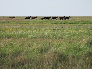
The Pontic–Caspian steppe, Pontic steppe, or Ukrainian steppe is the vast steppeland stretching from the northern shores of the Black Sea as far east as the Caspian Sea, from Dobruja in the northeastern corner of Bulgaria and southeastern Romania, through Moldova and eastern Ukraine across Russian Northern Caucasus, Southern and lower Volga regions to western Kazakhstan, forming part of the larger Eurasian steppe, adjacent to the Kazakh steppe to the east. It is a part of the Palearctic temperate grasslands, savannas, and shrublands ecoregion of the temperate grasslands, savannas, and shrublands biome.

The Kazakh Steppe, also called the Great Dala, ecoregion, of the Palearctic temperate grasslands, savannas, and shrublands biome, is a vast region of open grassland in northern Kazakhstan and adjacent portions of Russia, extending to the east of the Pontic steppe and to the west of the Emin Valley steppe, with which it forms part of the Eurasian steppe. Before the mid-nineteenth century it was called the Kirghiz steppe, 'Kirghiz' being an old name for the Kazakhs.

The Central Anatolia Region is a geographical region of Turkey.
The Eurasian Steppe, also called the Great Steppe or the steppes, is the vast steppe ecoregion of Eurasia in the temperate grasslands, savannas, and shrublands biome. It stretches from Bulgaria, Romania and Moldova through Ukraine, Russia, Kazakhstan, Xinjiang, and Mongolia to Manchuria, with one major exclave, the Pannonian steppe or Puszta, located mostly in Hungary.

A forest steppe is a temperate-climate ecotone and habitat type composed of grassland interspersed with areas of woodland or forest.

The Mongolian-Manchurian grassland ecoregion, also known as the Mongolian-Manchurian steppe, in the temperate grassland biome, is found in Mongolia, the Chinese Autonomous region of Inner Mongolia and northeastern China.

Western Australia occupies nearly one third of the Australian continent. Due to the size and the isolation of the state, considerable emphasis has been made of these features; it is the second largest administrative territory in the world, after Yakutia in Russia, despite the fact that Australia is only the sixth largest country in the world by area, and no other regional administrative jurisdiction in the world occupies such a high percentage of a continental land mass. It is also the only first level administrative subdivision to occupy the entire continental coastline in one cardinal direction.

The Great Plan for the Transformation of Nature, also known as Stalin's plan for the transformation of nature, was proposed by Joseph Stalin in the Soviet Union in the second half of the 1940s, for land development, agricultural practices and water projects to improve agriculture in the nation. Its propaganda motto and catchphrase was “the great transformation of nature”.
Mordovski Nature Reserve is a Russian 'zapovednik' in the north of the Republic of Mordovia, on the forested right bank of the Moksha River. It is in the transition zone of coniferous-deciduous forests and steppe. The reserve covers one-sixth of the Temnikovsky District of Mordovia. It was formally established in 1935, and covers a total area of 32,148 ha (124.12 sq mi). Its official name honors Pyotr Smidovich, a Soviet revolutionary and government official who was instrumental in establishing the Mordovsky Reserve.
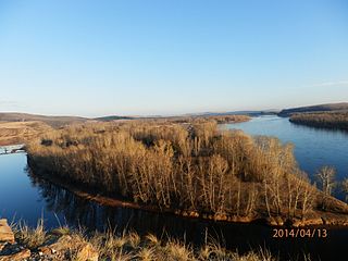
The South Siberian forest steppe ecoregion is a patchwork of grasslands and forests in the low-lying areas of south central Siberia. The region is one of high biodiversity as a transition zone between the West Siberian taiga to the north, and the Altai mountains to the south. There are also small patches to the east in Irkutsk Oblast. The ecoregion is in the Temperate grasslands, savannas, and shrublands biome, and the Palearctic ecozone, with a Humid Continental climate. It covers 161,874 km2 (62,500 sq mi).

The Zambezian region is a large biogeographical region in Africa. The Zambezian region includes woodlands, savannas, grasslands, and thickets, extending from east to west in a broad belt across the continent. The Zambezian region lies south of the rainforests of the Guineo-Congolian region. The Zambezian region is bounded by deserts and xeric shrublands on the southwest, the Highveld grasslands of South Africa to the south, and the subtropical Maputaland forests on the southeast.
The Indian Ocean coastal belt is one of the nine recognised biomes of South Africa. They are described in terms of their vegetation and climatic variations.
References
- 1 2 "Impact of the Environment on Human Migration in Eurasia: Proceedings of the NATO Advanced Research Workshop, Held in St. Petersburg, 15–18 November 2003", ISBN 1-4020-2654-4, pp. xi-xii
| This article relating to topography is a stub. You can help Wikipedia by expanding it. |