Stereoplotter

Last updated
Alpha 2000 analytical stereoplotter. Alpha2000.jpg
Alpha 2000 analytical stereoplotter.
Kelsh projection stereoplotter. Kelsh.jpg
Kelsh projection stereoplotter.

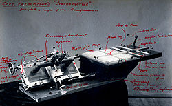
A stereoplotter uses stereo photographs to determine elevations. It has been the primary method to plot contour lines on topographic maps since the 1930s. Although the specific devices have advanced technologically, they are all based on the apparent change in position of a feature in the two stereo photographs.

Contents

Stereoplotters have changed as technology has improved. The first stereoplotters where projection stereoplotters they used only the light rays and optics to adjust the image. The Kelsh Plotter is an example of the projection stereoplotters. The analog stereoplotters came next and were more sophisticated in that they used more sophisticated optics to view the image. The analytical stereoplotter is used today. It incorporates a computer which does the work of mathematically aligning the images so that they line up properly. The analytic stereoplotter also allows for storing the data and redrawing at any desired scale.

Analogical

The stereoplotter requires two photographs that have considerable overlap (60%) and are corrected for distortion due to angle of photo. The photos are put onto transparent media and projected with a light source. Each image will be projected with overlap on the other. The operator, using a special set of optics, would then see the image as three-dimensional due to the differing perspective of each photo.

The optics of the stereoplotter is what allows the operator to plot the contours and features. The light source used to project the photo is what begins the process. One photo is projected using cyan/blue filter and the other photo is projected with a red filter. The operator wears a special set of glasses that have the same color filter for lenses. Seeing the left photo in blue light while the left eye has the blue filter and the right photo projected with red light and the right eye seeing through the red filter, the overlapping image becomes three-dimensional. The images will have control points that detail how the overlap of the photos should occur. The resultant overlapping image is called an anaglyph and is a three-dimensional model of the terrain. Once the two photos are projected and the desired control points aligned the operator will then start to record the desired elevations on the terrain by "flying" a light spot along the contours. If the light spot appears to hover above the terrain or appears to dive into the terrain, the operator knows that he has moved it too far away from a slope or too far toward a slope, respectively.

Originally, stereoplotters recorded the path of the flying light spot by directly scribing the path on a sheet of acetate or polyester coated with an opaque lacquer, which could be photographed to make the topographic map printing plates. If mistakes were made during contour tracing, the operator would daub some lacquer on the incorrect trace, allow it to dry and then try flying the light spot again. Current systems that use digital capture techniques allow simple erasure of part of the faulty data vector in computer memory, whereupon digitizing can resume. The digital database is then combined in a graphics program with annotations and symbols, ultimately being used to produce the map printing plates with a photoplotter.

The stereoplotter serves an important need of allowing aerial photos to become the base for contours and elevation maps. In the United States the largest use of topographic maps is the United States Geological Survey (USGS). The USGS has cataloged all of the territory of the United States and has produced topographic sheets for all of it. The sheets are most often used as 7.5' maps. This means there is 7.5' (0.125 degree) latitude by 7.5' (0.125 degree) longitude.

Capt FV Thompsons Stereoplotter.jpg

Analytical

With the introduction of computers, the analytical stereoplotter became a popular machine of choice for photogrammetry in the late 1960s to 1970s. A stereoplotter is an instrument that uses stereo photographs to determine elevations for the purpose of creating contours on topographic maps. Computers brought the capability to execute more precise calculations that ensure additional accurate output instead of approximations. This innovation also allowed a shift to a digital format rather than paper. Analytical stereoplotters edged out their analog predecessors and became the primary method of acquiring elevation data from stereo photographs.

Analytical stereoplotters use a mathematical projection based on the co-linearity (two vectors pointing in the same direction) equation model. The mechanical element of the instrument is a very accurate, computer-controlled device that compares two photographs simultaneously. The measurement system can be made to create a precise measurement for images because the photo stages only move via the x and y coordinates that are programmed into the system. The Kelsh stereoplotter by comparison, was built with a fixed focal distance and focal length of lens for projection. The ratio for scale was also fixed. In contrast, the analytical stereoplotter has no substantial limitations on focal length or scale.

The analytical stereoplotters viewing system has an optical train system, which usually includes the ability to change the focal length of a camera by adjusting the lens. Style, size and color of the measuring mark can be adjusted in viewing system as well. There is also an illumination adjustment to each eye.

The analytical stereoplotter measuring system is made up of an input device for the operator to move the elevation point in three dimensions. The input device is programmed, and the digital measure of the elevation point deviation is sent to the computer. With this information, the program then is able to set and locate points for both the interior and exterior of the elevation and record measurements. The transfer of information is immediate and thus the person operating the machine is able to make any necessary adjustments to the coordinates.

Elevations are measured in three steps, that include first measuring the interior orientation, then the relative orientation, and finally the absolute orientation. Interior orientation photographs are placed in relation to the center of the stereoplotter by aligning the fixed standard of reference points for measurement to corresponding points on the photograph. The focal length of the camera is also set. With relative orientation the angle of orientation of the camera relative to the place where the photos were, the stereo-photo is taken programmed in the stereoplotter. This allows the effects of parallax (distortion of the final stereo-photo) to be reduced. In absolute orientation, the ground coordinates of a position are used to scale the model. You can use this to get the x, y, or z coordinates of any position on the stereo photographs. This information can be used for the construction of contour lines for topographic maps.

Examples of Analytical Stereoplotters

Future outlook

The stereoplotter has been replaced by more modern photogrammetric methods, digital and automated, as in the case of structure from motion. Lidar (light radar) has also complemented photogrammetry for gathering elevation data. Lidar uses a laser pulse directed at features and detects the amount of time between when the pulse is emitted and when it is detected to determine the difference in elevations.

See also

Related Research Articles

Topographic map Medium to large scale map that shows a precise map of the terrain

Topography concerns the shape and character of the Earth's surface, and maps were among the first artifacts to record these observations. In modern mapping, a topographic map or topographic sheet is a type of map characterized by large-scale detail and quantitative representation of relief, usually using contour lines, but historically using a variety of methods. Traditional definitions require a topographic map to show both natural and artificial features. A topographic survey is typically based upon systematic observation and published as a map series, made up of two or more map sheets that combine to form the whole map. A topographic map series uses a common specification that includes the range of cartographic symbols employed, as well as a standard geodetic framework that defines the map projection, coordinate system, ellipsoid and geodetic datum. Official topographic maps also adopt a national grid referencing system.

Digital elevation model

A digital elevation model (DEM) is a 3D computer graphics representation of elevation data to represent terrain, commonly of a planet, moon, or asteroid. A "global DEM" refers to a discrete global grid. DEMs are used often in geographic information systems, and are the most common basis for digitally produced relief maps.

Topography study of the forms of land surfaces

Topography is the study of the forms and features of land surfaces. The topography of an area could refer to the surface forms and features themselves, or a description.

Astrophotography Specialized type of photography for recording images of astronomical objects and large areas of the night sky

Astrophotography, also known as astronomical imaging, is photography of astronomical objects, celestial events, and areas of the night sky. The first photograph of an astronomical object was taken in 1840, but it was not until the late 19th century that advances in technology allowed for detailed stellar photography. Besides being able to record the details of extended objects such as the Moon, Sun, and planets, astrophotography has the ability to image objects invisible to the human eye such as dim stars, nebulae, and galaxies. This is done by long time exposure since both film and digital cameras can accumulate and sum light photons over these long periods of time.

Stereoscopy Technique for creating or enhancing the illusion of depth in an image

Stereoscopy is a technique for creating or enhancing the illusion of depth in an image by means of stereopsis for binocular vision. The word stereoscopy derives from Greek στερεός (stereos) 'firm, solid', and σκοπέω (skopeō) 'to look, to see'. Any stereoscopic image is called a stereogram. Originally, stereogram referred to a pair of stereo images which could be viewed using a stereoscope.

Remote sensing Acquisition of information at a significant distance from the subject

Remote sensing is the acquisition of information about an object or phenomenon without making physical contact with the object and thus is in contrast to on-site observation. The term is applied especially to acquiring information about the Earth. Remote sensing is used in numerous fields, including geography, land surveying and most Earth science disciplines ; it also has military, intelligence, commercial, economic, planning, and humanitarian applications, among others.

Aerial photography Taking images of the ground from the air

Aerial photography is the taking of photographs from an aircraft or other flying object. Platforms for aerial photography include fixed-wing aircraft, helicopters, unmanned aerial vehicles, balloons, blimps and dirigibles, rockets, pigeons, kites, parachutes, stand-alone telescoping and vehicle-mounted poles. Mounted cameras may be triggered remotely or automatically; hand-held photographs may be taken by a photographer.

Photogrammetry Taking measurements using photography

Photogrammetry is the science and technology of obtaining reliable information about physical objects and the environment through the process of recording, measuring and interpreting photographic images and patterns of electromagnetic radiant imagery and other phenomena.

Orthophoto

An orthophoto, orthophotograph or orthoimage is an aerial photograph or satellite imagery geometrically corrected ("orthorectified") such that the scale is uniform: the photo or image follows a given map projection. Unlike an uncorrected aerial photograph, an orthophoto can be used to measure true distances, because it is an accurate representation of the Earth's surface, having been adjusted for topographic relief, lens distortion, and camera tilt.

Vignetting Reduction of an images brightness or saturation toward the periphery compared to the image center

In photography and optics, vignetting (; French: vignette) is a reduction of an image's brightness or saturation toward the periphery compared to the image center. The word vignette, from the same root as vine, originally referred to a decorative border in a book. Later, the word came to be used for a photographic portrait that is clear at the center and fades off toward the edges. A similar effect is visible in photographs of projected images or videos off a projection screen, resulting in a so-called "hotspot" effect.

3D scanning

3D scanning is the process of analyzing a real-world object or environment to collect data on its shape and possibly its appearance. The collected data can then be used to construct digital 3D models.

Perspective control

Perspective control is a procedure for composing or editing photographs to better conform with the commonly accepted distortions in constructed perspective. The control would:

Structure from motion (SfM) is a photogrammetric range imaging technique for estimating three-dimensional structures from two-dimensional image sequences that may be coupled with local motion signals. It is studied in the fields of computer vision and visual perception. In biological vision, SfM refers to the phenomenon by which humans can recover 3D structure from the projected 2D (retinal) motion field of a moving object or scene.

SOCET SET is a software application that performs functions related to photogrammetry. It is developed and published by BAE Systems. SOCET SET was among the first commercial digital photogrammetry software programs. Prior to the development of digital solutions, photogrammetry programs were primarily analog or custom systems built for government agencies.

Terrain cartography

Terrain cartography or relief mapping is the depiction of the shape of the surface of the Earth on a map, using one or more of several techniques that have been developed. Terrain or relief is an essential aspect of physical geography, and as such its portrayal presents a central problem in cartographic design, and more recently geographic information systems and geovisualization.

3D reconstruction

In computer vision and computer graphics, 3D reconstruction is the process of capturing the shape and appearance of real objects. This process can be accomplished either by active or passive methods. If the model is allowed to change its shape in time, this is referred to as non-rigid or spatio-temporal reconstruction.

Ethiopia – United States Mapping Mission

The Ethiopia-United States Mapping Mission, also known as the Ethi-U.S. Mapping Mission, was an operation undertaken by the United States Army during the 1960s to provide up-to-date topographic map coverage of the entire country of Ethiopia. The soldiers who conducted the mapping operations on the ground during that time used the latest surveying and mapping techniques and were exposed to many hardships and dangers, but they completed their mission near the end of the decade. The maps that were created still serve as the base maps for the country of Ethiopia and are presently being updated and maintained by the Ethiopian Mapping Authority.

A3 Digital Mapping System consists of a digital airborne camera and an automatic ground processing system produced by VisionMap. The A3 camera captures imagery using a sweep mechanism, which collects high resolution vertical and oblique imagery simultaneously. The captured data is post-processed by the A3 LightSpeed ground processing system in order to create the final output products. The A3 System is used by numerous national and regional mapping agencies, as well as commercial mapping firms.

Digital outcrop model

A digital outcrop model (DOM), also called a virtual outcrop model, is a digital 3D representation of the outcrop surface, mostly in a form of textured polygon mesh.

DAT/EM Systems International is an Alaska-based company that develops digital photogrammetric mapping applications to extract and edit 3D vector terrain and object features from stereo imagery and point clouds. DAT/EM Systems International develops solutions for the photogrammetry, engineering & GIS industries.

References