Fair Haven is a village located on the southern shore of Lake Ontario in Cayuga County, New York, United States. The population was 724 at the 2020 census. Fair Haven is within the town of Sterling and is northwest of Syracuse. The village is on Little Sodus Bay, an arm of Lake Ontario.
Tuxedo is a town located in Orange County, New York, United States, along the Ramapo River. As of the 2010 census, the town had a total population of 3,624. The town is in the southeastern part of the county in the Ramapo Mountains. New York State Route 17 and the New York State Thruway pass through the town. The name is derived from a Lenape word tucseto, which has several known meanings.

Warwick is a town in the southwestern part of Orange County, New York, United States. Its population was 32,027 at the 2020 census. The town contains three villages and eight hamlets.

Canisteo is a village in Steuben County, New York, United States. The population was 2,270 at the 2010 census.

Greenwood Lake is an interstate lake approximately seven miles (11 km) long, straddling the border of New York and New Jersey. It is located in the Town of Warwick and the Village of Greenwood Lake, New York and West Milford, New Jersey. It is the source of the Wanaque River.

Upper Montclair is a New Jersey Transit station in Upper Montclair, New Jersey, a census-designated place of Montclair, New Jersey. The station is part of the Montclair-Boonton Line. The station is located between two grade level crossings on Bellevue Avenue and Lorraine Avenue, and between North Mountain Avenue and Upper Montclair Plaza parallel to the railroad, and is within steps of the Upper Montclair Business District. The station is at mile point 13.7 on the Boonton Line. Closing the grade crossing of Lorraine Avenue is being considered for safety reasons.

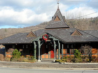
Little Falls is the second of two stations maintained by NJ Transit in Little Falls, New Jersey. The station, on the Montclair-Boonton Line is the first to receive limited revenue service due to the end of electrification at the site of the former Great Notch station. Little Falls station, located at Union Avenue in downtown has one side platform with the 1915 station depot, built of brick on the side. The station contains one track for revenue service, and a passing siding for trains. The station is the eighth fare zone, costing $8 for a one-way ticket to Hoboken Terminal and $1.25 more to transfer at Newark Broad Street to New York Pennsylvania Station. The station has 194 parking spaces, 134 on Railroad Avenue at Montclair Avenue and 60 more along Montclair Avenue. A ticket machine is available. The station is not accessible for handicapped persons. Anyone wishing to receive train service for handicapped must go to Montclair State University station or Wayne Route 23 Transit Center across the Passaic River in Wayne.

Mountain View, signed on the platform as Mountain View–Wayne, is a station on the Montclair-Boonton Line of NJ Transit in Wayne, New Jersey. Prior to the Montclair Connection in 2002, the station was served by the Boonton Line. The station is located on Erie Avenue, just off of US 202 and Route 23 in Downtown Wayne. Since January 2008, Mountain View station is the second of two stations in Wayne, the other being the Wayne Route 23 Transit Center, a station off the Westbelt interchange.

Allendale is a NJ Transit rail station served by its Main and Bergen County lines as well as Port Jervis Line trains. The station is located at the railroad next to Allendale, Park and Myrtle avenues in Downtown Allendale. The station consists of two low-level platforms serving trains heading between Hoboken Terminal and Suffern. Some westbound trains headed for Port Jervis also stop at Allendale. The station has two ticket vending machines along the inbound platform with three parking lots for commuters. The railroad depot, constructed in 1870, is a combined passenger and freight depot, with a waiting area for passengers at the south end of the building while the northern end is unused.

Mahwah is a NJ Transit rail station Mahwah, New Jersey served by the Main Line, Bergen County Line, and Port Jervis Line.
Sterlington, was a tiny community located in the Town of Ramapo, Rockland County, New York, United States located between Suffern and Sloatsburg.

The New York and Greenwood Lake Railway owned a line between Croxton, Jersey City, New Jersey and Greenwood Lake, New York. Service on the line was provided by the Erie Railroad.

Pompton Plains is a former railroad station in Pequannock Township, Morris County, New Jersey. United States. Located at 33 Evans Place in the Pompton Plains section of Pequannock, the station is a former stop on the Erie Railroad's Greenwood Lake Division. The station was a single side-platform station with service from Wanaque–Midvale station in Wanaque to Pavonia Terminal in Jersey City, where connections were made to ferries to New York City. The next station north was Pompton–Riverdale after 1951. The next station south was Pequannock station.
Bellvale is a wooded hamlet in the town of Warwick in Orange County, New York, United States. Situated in the morning shadow of Bellvale Mountain along New York State Route 17A, Bellvale was the site of an iron forge destroyed by British Army soldiers in 1750; many of its homes and other structures date from before American independence. While close to New York City, its location in the Warwick Valley has prevented suburban development.
The recorded history of Rockland County, New York begins on February 23, 1798, when the county was split off from Orange County, New York and formed as its own administrative division of the state of New York. It is located 6 miles (9.7 km) north-northwest of New York City, and is part of the New York Metropolitan Area. The county seat is the hamlet of New City. The name comes from rocky land, an early description of the area given by settlers. Rockland is New York's southernmost county west of the Hudson River. It is suburban in nature, with a considerable amount of scenic designated parkland. Rockland County does not border any of the New York City boroughs, but is only 9.5 miles (15.3 km) north of Manhattan at the counties' two respective closest points
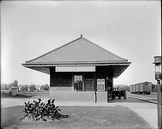
Wanaque–Midvale was a former commuter railroad station of the Erie Railroad's New York and Greenwood Lake Railway branch in Wanaque, New Jersey, United States. When built in 1873, the station served trains running from Pavonia Terminal in Jersey City to Sterling Forest on the New York–New Jersey border alongside Greenwood Lake and trains going to Ringwood on the Ringwood Branch. At the time there were two stations, one at Wanaque and one at Midvale. The next station northbound towards Sterling Forest was Boardville; heading towards Ringwood it was Erskine. The next station south was Haskell.

Essex Fells was the terminus of the Erie Railroad's Caldwell Branch in the Essex County community of Essex Fells, New Jersey. Located at the junction of Oak Lane and Chestnut Lane in Essex Fells, the station was also a connection to the Morristown and Erie Railroad, which continued west through Roseland towards Morristown. The next station north from the Essex Fells station was Caldwell heading northward to Great Notch in Little Falls, where the line connected to the New York and Greenwood Lake Railroad.

Caldwell station was the fourth of six stations on the Erie Railroad Caldwell Branch, located in Caldwell, New Jersey. The station was located on Bloomfield Avenue just north-east of Caldwell College. The station opened in 1891 as the terminus of the Caldwell Railroad, a branch of the New York and Greenwood Lake Railroad that forked off at Great Notch station in Little Falls, Passaic County.

Pompton–Riverdale is a former railroad station in the borough of Riverdale. Morris County, New Jersey, United States. Located at 13 Pompton–Hamburg Turnpike, the station was a stop on the Greenwood Lake Division of the Erie Railroad. A single side platform station with two tracks, the current station was built in 1919. The next station to the north was Pompton Junction, where connections were available to the New York, Susquehanna and Western Railroad, another Erie Railroad subsidiary. The next station south was Pompton Plains.

Pompton Junction is a former railroad station and active railroad junction in the borough of Pompton Lakes, New Jersey, United States. The station is located on the New York and Greenwood Lake Railway and the New York, Susquehanna and Western Railway, both subsidiaries of the Erie Railroad. Pompton Junction contained two side platforms at a diamond crossing, with a station depot on the Susquehanna Railroad side and a station canopy on the Greenwood Lake side. A railroad tower with the telegraph call letters "PJ" was present on the Greenwood Lake side of the station.
