Related Research Articles

Blackmoor Copse is a woodland in southeast Wiltshire, England, managed as a nature reserve by the Wiltshire Wildlife Trust. The copse lies within Pitton and Farley parish, about 5+1⁄2 miles (9 km) east of Salisbury.
Old Town Railway Cutting is a 1.78 hectare geological Site of Special Scientific Interest in Swindon, Wiltshire, notified in 1975. It is near the site of the former Swindon Town railway station.
Seend Cleeve Quarry is a 7.5 acres (3.0 ha) Geological Site of Special Scientific Interest at Seend Cleeve, Wiltshire, England, notified in 1987. It is important for its strata from the Oxfordian stage of the Jurassic period, containing fossil ammonites and bivalves which aid stratigraphy.
Baverstock Juniper Bank is a 2.6 hectare Biological Site of Special Scientific Interest to the north of the village of Baverstock in Wiltshire, England. Baverstock Juniper Bank is within the Cranborne Chase and West Wiltshire Downs Area of Outstanding Natural Beauty. The ungrazed chalk grassland is home to over 500 bushes of the lowland juniper, Juniperus communis, subspecies communis. Their seeds attract flocks of finches and yellowhammers to the location as a feeding site in winter. Uncommon species such a horseshoe vetch and pyramidal orchid are to be found at the SSSI. Butterflies such as the brimstone, speckled wood and small heath have been seen visiting the site.
Bencroft Hill Meadows is a 5.1 hectare biological Site of Special Scientific Interest some 3 miles (5 km) to the east of the town of Chippenham in Wiltshire, England, notified in 1988. The site is a flora-rich example of unimproved pasture on the Oxford Clay Vale of North Wiltshire which attracts butterflies such as the small copper, small heath and common blue.
Scratchbury & Cotley Hills SSSI is a 53.5 hectare biological Site of Special Scientific Interest at Norton Bavant in Wiltshire, England, notified in 1951. The Iron Age hillfort of Scratchbury Camp occupies the summit of the hill.

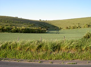
Upton Cow Down is a 16.4 hectare biological Site of Special Scientific Interest in Wiltshire. The down is an area of chalk grassland on the western edge of Salisbury Plain. It lies one mile south of the town of Westbury, above the village of Upton Scudamore.

Stratford Toney Down is a 23.1 hectare biological Site of Special Scientific Interest in Wiltshire, England, which was notified in 1987. The site lies in a shallow dry valled in the south of Stratford Tony parish, about 5 miles (7.5 km) south-west of Salisbury. It is important for the botanically rich chalk grassland – mainly sheep's fescue and meadow oat-grass – which supports several nationally rare plant and butterfly species.

Tytherington Down is a 5.9 hectares biological Site of Special Scientific Interest in Wiltshire, England, notified in 1975. The site spans a dry valley some 1+1⁄2 miles (2.4 km) south of the village of Tytherington and 5 miles (8 km) southeast of Warminster.
Burcombe Down is an area of chalk grassland situated on a north-facing scarp slope to the south of Burcombe in Wiltshire, England. Because of its species-rich plant communities, an area of 47.1 hectares of the Down has been notified as a biological Site of Special Scientific Interest, notification originally taking place in 1971.
Bradley Woods is an area of woodland in Wiltshire, south of Longleat Woods and north of Gare Hill.
Upper Waterhay Meadow is a 2.8 hectare biological Site of Special Scientific Interest in north Wiltshire, England, notified in 1971. It lies on the Thames floodplain in Ashton Keynes parish, downstream (east) of Ashton Keynes village and west of the town of Cricklade.
East Harnham Meadows is a 17.29 hectare biological Site of Special Scientific Interest in Wiltshire, England, in the Harnham suburb to the south-east of the city of Salisbury. The water-meadows are in the flood-plain of the River Avon.
Stoke Common Meadows is a biological Site of Special Scientific Interest in north Wiltshire, England. The 10.2 hectare site is in Purton parish, 1.6 miles (2.6 km) west of Purton Common hamlet and 3 miles (5 km) south-west of the town of Cricklade.

Ravensroost Wood is a 43.7 hectare biological Site of Special Scientific Interest in north Wiltshire, England. The site lies about 1.5 miles (2.4 km) south of Minety village and straddles the boundary between Minety and Braydon parishes.

Pike Corner is a 15.2 hectare biological Site of Special Scientific Interest in north Wiltshire, England, notified in 1986. The site lies southwest of Ashton Keynes village and covers two low-lying meadows in the floodplain of the Swill Brook.
Harries Ground, Rodbourne is a 6.87 hectare biological Site of Special Scientific Interest in Wiltshire, England, notified in 2003. It lies to the south of Rodbourne in north Wiltshire, about 3 miles (5 km) south of Malmesbury.
Lower Coombe and Ferne Brook Meadows is an 11.34 hectare biological Site of Special Scientific Interest in Wiltshire, England which sits on the Upper Greensand and Gault Clay. The site is home to rare fen meadow and neutral grassland communities in an unimproved grassland. Species such as Triglochin palustris, Caltha palustris and Oenanthe pimpinelloides can be found at the location. Three streams, which form headwaters of the River Nadder flow through the site. It was notified in 2002.

The River Nadder is a tributary of the River Avon, flowing in south Wiltshire, England.
Restrop Farm and Brockhurst Wood is a 56.5 hectare biological Site of Special Scientific Interest in Wiltshire, England, about one mile (1.6 km) south-west of Purton village.
References
- ↑ "Map of Stert Brook Exposure SSSI". MAGIC. Natural England. Retrieved 27 February 2023.
- ↑ "Citation for Stert Brook Exposure SSSI" (PDF). Natural England. Retrieved 27 February 2023.
51°19′26″N1°58′37″W / 51.324°N 1.977°W
| | This article about a Site of Special Scientific Interest in England is a stub. You can help Wikipedia by expanding it. |
| | This article about a location in Wiltshire is a stub. You can help Wikipedia by expanding it. |