Lawton–Fort Sill Regional Airport is two miles south of Lawton, in Comanche County, Oklahoma. It is used for military aviation from nearby Fort Sill and Sheppard Air Force Base and is served by American Eagle. Allegiant Air runs occasional charters.

University of Oklahoma Westheimer Airport is a public use airport in Norman, in Cleveland County, Oklahoma. It is owned by the University of Oklahoma. The National Plan of Integrated Airport Systems for 2021–2025 categorized it as a reliever airport.

South Alabama Regional Airport at Bill Benton Field, formerly known as Andalusia-Opp Airport, is a public use airport in Covington County, Alabama, United States. It is located four nautical miles east of the central business district of Andalusia and about 9 miles (14 km) west of Opp. The airport is governed by the South Alabama Regional Airport Authority, with members appointed by the Andalusia City Council, the Opp Council, and the Covington County Commission.

West Woodward Airport is in Woodward County, Oklahoma, United States, seven miles west of Woodward, which owns it. The National Plan of Integrated Airport Systems for 2011–2015 called it a general aviation airport.

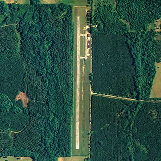
Centre Municipal Airport is a city-owned, public-use airport located three nautical miles east of the central business district of Centre, a city in Cherokee County, Alabama, United States. It is owned by the City of Centre.

Clayton Municipal Airport is a city-owned, public-use airport located two nautical miles west of the central business district of Clayton, a city in Barbour County, Alabama, United States.
Carl Folsom Airport is a public-use airport located two nautical miles west of the central business district of Elba, a city in Coffee County, Alabama, United States. It is owned by the Elba Airport Authority.
Greensboro Municipal Airport is a city-owned public-use airport located three nautical miles southwest of the central business district of Greensboro, a city in Hale County, Alabama, United States.

Posey Field is a city-owned public-use airport located three nautical miles northeast of the central business district of Haleyville, a city in Winston County, Alabama, United States.

Hartselle–Morgan County Regional Airport is a public-use airport located two nautical miles south of the central business district of Hartselle, a city in Morgan County, Alabama, United States. The airport was formerly known as Rountree Field, named in the 1960s for Asa Rountree Sr., a former head of the Alabama Department of Aeronautics.
Stan Stamper Municipal Airport is a city-owned, public-use airport located two nautical miles (3.7 km) northwest of the central business district of Hugo, a city in Choctaw County, Oklahoma, United States. According to the FAA's National Plan of Integrated Airport Systems for 2009–2013, it is classified as a general aviation airport.
Kokhanok Airport is a state-owned public-use airport located two nautical miles (3.7 km) southwest of the central business district of Kokhanok, in the Lake and Peninsula Borough of the U.S. state of Alaska.
Clarks Point Airport is a state-owned public-use airport located in Clarks Point, a city in the Dillingham Census Area of the U.S. state of Alaska.
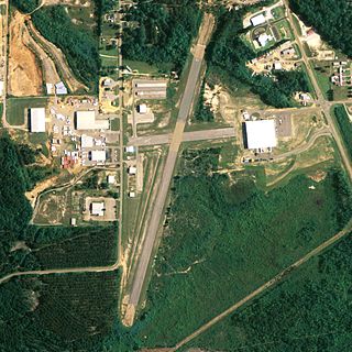
Centre–Piedmont–Cherokee County Regional Airport is a public-use airport in Cherokee County, Alabama, United States. The airport is located five nautical miles south of Centre, Alabama and 10 nautical miles north of Piedmont, Alabama. It is owned by the CPCCR Airport Authority and was dedicated on October 14, 2010.
Ophir Airport is a state-owned public-use airport located in Ophir, in the Yukon-Koyukuk Census Area of the U.S. state of Alaska.
Portage Creek Airport is a state-owned public-use airport in Portage Creek, located in the Dillingham Census Area of the U.S. state of Alaska. This airport is included in the FAA's National Plan of Integrated Airport Systems for 2011–2015, which categorized it as a general aviation airport.
Grand Lake Regional Airport is a privately owned, public use airport in Delaware County, Oklahoma, United States. It is located on Monkey Island, a peninsula on the northern shore of Grand Lake o' the Cherokees. The airport is nine nautical miles southeast of Afton, a city in Ottawa County, Oklahoma.
Nowata Municipal Airport is a city-owned, public-use airport located two nautical miles (4 km) northeast of the central business district of Nowata, a city in Nowata County, Oklahoma, United States. It was included in the National Plan of Integrated Airport Systems for 2007–2011, which categorized it as a general aviation facility.
Medford Municipal Airport is a city-owned, public-use airport located one nautical mile (2 km) southwest of the central business district of Medford, a city in Grant County, Oklahoma, United States. It is included in the National Plan of Integrated Airport Systems for 2011–2015, which categorized it as a general aviation facility.
Tahlequah Municipal Airport is a city-owned, public-use airport located two nautical miles (4 km) northwest of the central business district of Tahlequah, a city in Cherokee County, Oklahoma, United States. It is included in the National Plan of Integrated Airport Systems for 2011–2015, which categorized it as a general aviation facility.
