Stinica

Last updated
Stinica
Stinica
Interactive map of Stinica
Croatia location map.svg
Red pog.svg
Stinica
Location of Stinica in Croatia
Coordinates: 44°44′24″N14°53′56″E / 44.7401°N 14.8988°E / 44.7401; 14.8988
Country Flag of Croatia.svg  Croatia
County Flag of Lika-Senj County.svg Lika-Senj
City Senj
Area
[1]
  Total
89.9 km2 (34.7 sq mi)
Population
 (2021) [2]
  Total
61
  Density0.68/km2 (1.8/sq mi)
Time zone UTC+1 (CET)
  Summer (DST) UTC+2 (CEST)
Postal code [3]
53270 Senj
Area code +385 (0)53
Stinica - ferry port & Velebit mountain Stinica - ferry port ^ Velebit montain - panoramio.jpg
Stinica - ferry port & Velebit mountain

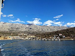
Stinica is a settlement in the City of Senj in Croatia. [4] In 2021, its population was 61. [2]

Demographics

Stinica: Population trends 1857–2021
v

References

  1. Register of spatial units of the State Geodetic Administration of the Republic of Croatia. Wikidata   Q119585703.
  2. 1 2 "Population by Age and Sex, by Settlements" (xlsx). Census of Population, Households and Dwellings in 2021. Zagreb: Croatian Bureau of Statistics. 2022.
  3. List of Croatian settlements and delivery post offices. Wikidata   Q125763583.
  4. "Zakon o područjima županija, gradova i općina u Republici Hrvatskoj". Narodne novine (in Croatian). Archived from the original on 2023-06-07.