
Tameside is a metropolitan borough of Greater Manchester, England, named after the River Tame, which flows through it, and includes the towns of Ashton-under-Lyne, Audenshaw, Denton, Droylsden, Dukinfield, Hyde, Mossley and Stalybridge. Tameside is bordered by the metropolitan boroughs of Stockport to the south, Oldham to the north and northeast, Manchester to the west, and to the east by the Borough of High Peak in Derbyshire. As of 2022, the population of Tameside was 232,753, making it the 8th-most populous borough of Greater Manchester.

Trafford is a metropolitan borough of Greater Manchester, England, with an estimated population of 236,301 in 2022. It covers 106 square kilometres (41 sq mi) and includes the area of Old Trafford and the towns of Altrincham, Stretford, Urmston, Partington and Sale. The borough was formed in 1974 as a merger of six former districts and part of a seventh. The River Mersey flows through the borough, separating North Trafford from South Trafford, and the historic counties of Lancashire and Cheshire. Trafford is the seventh-most populous district in Greater Manchester.

Stockport is a town in Greater Manchester, England, 8 miles (13 km) south-east of Manchester, 9 miles (14 km) south-west of Ashton-under-Lyne and 12 miles (19 km) north of Macclesfield. The Rivers Goyt and Tame merge to create the River Mersey here. It is the main settlement of the wider Metropolitan Borough of Stockport. In 2011 it had a population of 137,130.

Warburton is a village and civil parish in the Metropolitan Borough of Trafford, Greater Manchester, England. Historically in Cheshire, it lies on the south bank of the River Mersey. The village remains predominantly rural. Altrincham is the nearest town. At the 2001 census, the parish had a population of 286.
Park Bridge is an area of Ashton-under-Lyne, in the Metropolitan Borough of Tameside, in Greater Manchester, England. It is situated in the Medlock Valley, by Ashton-under-Lyne's border with Oldham. Park Bridge anciently lay within the medieval manor of Ashton; however, there is no record of Park Bridge until the 17th century. The name is probably a reference to the medieval Lyme Park, in the north west of the manor of Ashton. For nearly two hundred years from the 18th to the 20th centuries it was the site of the Park Bridge Ironworks.
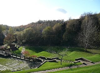
Buckton Castle was a medieval enclosure castle near Carrbrook in Stalybridge, Greater Manchester, England. It was surrounded by a 2.8-metre-wide (9 ft) stone curtain wall and a ditch 10 metres (33 ft) wide by 6 metres (20 ft) deep. Buckton is one of the earliest stone castles in North West England and only survives as buried remains overgrown with heather and peat. It was most likely built and demolished in the 12th century. The earliest surviving record of the site dates from 1360, by which time it was lying derelict. The few finds retrieved during archaeological investigations indicate that Buckton Castle may not have been completed.

The Hat Works is a museum in Stockport, Greater Manchester, England, which opened in 2000. Before that, smaller displays of hatting equipment were exhibited in Stockport Museum and in the former Battersby hat factory.

Castleshaw Roman fort was a castellum in the Roman province of Britannia. Although there is no evidence to substantiate the claim, it has been suggested that Castleshaw Roman fort is the site of Rigodunum, a Brigantian settlement. The remains of the fort are located on Castle Hill on the eastern side of Castleshaw Valley at the foot of Standedge but overlooking the valley. The hill is on the edge of Castleshaw in Greater Manchester. The fort was constructed in c. AD 79, but fell out of use at some time during the 90s. It was replaced by a smaller fortlet, built in c. 105, around which a civilian settlement grew. It may have served as a logistical and administrative centre, although it was abandoned in the 120s.
The medieval Knepp Castle is to the west of the village of West Grinstead, West Sussex, England near the River Adur and the A24. The castle was probably founded by the Braose family in the 12th century. King John confiscated the castle along with the Braose lands in 1208. Knepp was used as a hunting lodge, and John visited the castle several times. He ordered its destruction in both 1215 and 1216 during the First Barons' War.
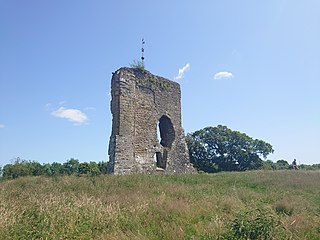
Watch Hill Castle is a medieval motte-and-bailey on the boundary of Bowdon and Dunham Massey, Greater Manchester, England. It is a scheduled monument. The castle is located north of the River Bollin and south of a deep ravine.
Dunham Castle is an early medieval castle in Dunham Massey, Greater Manchester, England.
Ullerwood Castle is an early medieval castle, possibly a shell keep, in Ringway, Manchester, England. The castle is first referred to in 1173, in a document stating Hamon de Masci held the castles of Ullerwood and Dunham. There is no other contemporary documented reference to the castle. Ullerwood Castle has been confused with Watch Hill Castle in nearby Bowdon, but the two are separate castles, though both probably owned by de Masci. The site is underneath a house and surrounded by trees. ° It is possible that the site of the castle is at the top of Castle Hill at 53°20'57"N, 2°17'32"W. Examination of aerial views of the location on Google Earth indicates a circular structure with less well defined adjacent structures to the South East. The site is very close to a runway at Manchester Airport and lies within a restricted area.
There is evidence of activity around Reddish – a settlement in Greater Manchester, England – before the Norman conquest in the presence of Nico Ditch and some Saxon coins. The recorded history of Reddish begins at the turn of the 13th century when it was documented as "Redich". Reddish remained a predominantly rural settlement throughout the medieval period, but expanded to become a mixed industrial and residential area during the 19th century. It developed rapidly during the Industrial Revolution, and still retains landmarks from that period, such as Houldsworth Mill.

There are 37 scheduled monuments in Greater Manchester, a metropolitan county in North West England. In the United Kingdom, a scheduled monument is a "nationally important" archaeological site or historic building that has been given protection against unauthorised change by being placed on a list by the Secretary of State for Digital Culture, Media and Sport; Historic England recommends sites for scheduling to the Secretary of State. Scheduled monuments are defined in the Ancient Monuments and Archaeological Areas Act 1979 and the National Heritage Act 1983. There are nearly 20,000 entries on the schedule, which is maintained by Historic England as part of the National Heritage List for England; more than one site can be included in a single entry. While a scheduled monument can also be recognised as a listed building, Historic England's aim is to set the most appropriate form of protection in place for the building or site. Applications to deschedule a site are administered Historic England, who will carry out an assessment and make a recommendation to the Secretary of State.

Manchester Castle was a medieval fortified manor house, probably located on a bluff where the rivers Irk and Irwell meet, near to Manchester Cathedral, where Chetham's School of Music now is, putting it near the edge of the medieval township of Manchester.
Mellor hill fort is a prehistoric site in North West England dating from the British Iron Age – about 800 BC to 100 AD. Situated on a hill in Mellor, Greater Manchester, on the western edge of the Peak District, the hill fort overlooks the Cheshire Plain. Although the settlement was founded during the Iron Age, evidence exists of activity on the site as far back as 8,000 BC; during the Bronze Age the hill may have been an area where funerary practices were performed. Artefacts such as a Bronze Age amber necklace indicate the site was high status and that its residents took part in long-distance trade. The settlement was occupied into the Roman period. After the site was abandoned, probably in the 4th century, it was forgotten until its rediscovery in the 1990s.

Mellor Mill, also known as Bottom's Mill, was a six-story cotton mill in Marple, Greater Manchester built by Samuel Oldknow in 1793. This was a six-storey, 42-foot (13 m) wide and 210-foot (64 m) long mill with additional three-storey wings making it 400 feet (120 m) in all. The mill was built for Samuel Oldknow and used to spin coarse counts. It was originally driven by the Wellington water wheel. The River Goyt, and with it the then county boundary between Derbyshire and Cheshire was diverted and a weir built, the leat fed a millpond that in later times was named the Roman Lakes. This in turn fed a second mill pond along with water from reservoir in Linnet Clough. Supplementary power was provided by a second exterior wheel known as the Waterloo wheel. The Mill reached its peak production in 1804, when 10,080 spindles were operating and around 550 people were employed. It was destroyed by fire in 1892.
